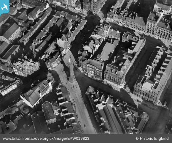
EPW019823 ENGLAND (1927). Grey's Monument and environs, Newcastle upon Tyne, 1927
© Copyright OpenStreetMap contributors and licensed by the OpenStreetMap Foundation. 2025. Cartography is licensed as CC BY-SA.
Nearby Images (15)
Details
| Title | [EPW019823] Grey's Monument and environs, Newcastle upon Tyne, 1927 |
| Reference | EPW019823 |
| Date | October-1927 |
| Link | |
| Place name | NEWCASTLE UPON TYNE |
| Parish | |
| District | |
| Country | ENGLAND |
| Easting / Northing | 424886, 564426 |
| Longitude / Latitude | -1.6111801268643, 54.973750414307 |
| National Grid Reference | NZ249644 |


![[EPW019823] Grey's Monument and environs, Newcastle upon Tyne, 1927](http://britainfromabove.org.uk/sites/all/libraries/aerofilms-images/public/100x100/EPW/019/EPW019823.jpg)
![[EPW019822] Grey's Monument and environs, Newcastle upon Tyne, 1927](http://britainfromabove.org.uk/sites/all/libraries/aerofilms-images/public/100x100/EPW/019/EPW019822.jpg)
![[EPW010412] Blackett Street and environs, Newcastle upon Tyne, 1924](http://britainfromabove.org.uk/sites/all/libraries/aerofilms-images/public/100x100/EPW/010/EPW010412.jpg)
![[EAW017458] Eldon Square, Grey Street and Pilgrim Street, Newcastle upon Tyne, 1948. This image has been produced from a print.](http://britainfromabove.org.uk/sites/all/libraries/aerofilms-images/public/100x100/EAW/017/EAW017458.jpg)
![[EPW010385] The Earl Grey Monument, Newcastle upon Tyne, 1924](http://britainfromabove.org.uk/sites/all/libraries/aerofilms-images/public/100x100/EPW/010/EPW010385.jpg)
![[EPW010390] The junction of Northumberland Street and New Bridge Street, Newcastle upon Tyne, 1924. This image has been produced from a print.](http://britainfromabove.org.uk/sites/all/libraries/aerofilms-images/public/100x100/EPW/010/EPW010390.jpg)
![[EAW017457] Gallowgate, Eldon Square and the city centre, Newcastle upon Tyne, 1948. This image has been produced from a print.](http://britainfromabove.org.uk/sites/all/libraries/aerofilms-images/public/100x100/EAW/017/EAW017457.jpg)
![[EPW059907] A cityscape from Tyne Bridge to the Town Moor, Newcastle Upon Tyne, 1938](http://britainfromabove.org.uk/sites/all/libraries/aerofilms-images/public/100x100/EPW/059/EPW059907.jpg)
![[EPW019819] Eldon Square, Newcastle upon Tyne, 1927](http://britainfromabove.org.uk/sites/all/libraries/aerofilms-images/public/100x100/EPW/019/EPW019819.jpg)
![[EPW059905] A cityscape from Tyne Bridge to the Town Moor, Newcastle Upon Tyne, 1938](http://britainfromabove.org.uk/sites/all/libraries/aerofilms-images/public/100x100/EPW/059/EPW059905.jpg)
![[EPW059906] A cityscape from Pilgrim Street to Northumberland Street, Newcastle Upon Tyne, 1938](http://britainfromabove.org.uk/sites/all/libraries/aerofilms-images/public/100x100/EPW/059/EPW059906.jpg)
![[EPW059908] A cityscape from Pilgrim Street to the Town Moor, Newcastle Upon Tyne, 1938](http://britainfromabove.org.uk/sites/all/libraries/aerofilms-images/public/100x100/EPW/059/EPW059908.jpg)
![[EPW059910] A cityscape from Pilgrim Street to the Town Moor, Newcastle Upon Tyne, 1938](http://britainfromabove.org.uk/sites/all/libraries/aerofilms-images/public/100x100/EPW/059/EPW059910.jpg)
![[EPW059911] A cityscape from Pilgrim Street to the Town Moor, Newcastle Upon Tyne, 1938. This image has been produced from a damaged negative.](http://britainfromabove.org.uk/sites/all/libraries/aerofilms-images/public/100x100/EPW/059/EPW059911.jpg)
![[EPW060865] The city, Newcastle upon Tyne, from the west, 1939](http://britainfromabove.org.uk/sites/all/libraries/aerofilms-images/public/100x100/EPW/060/EPW060865.jpg)
