
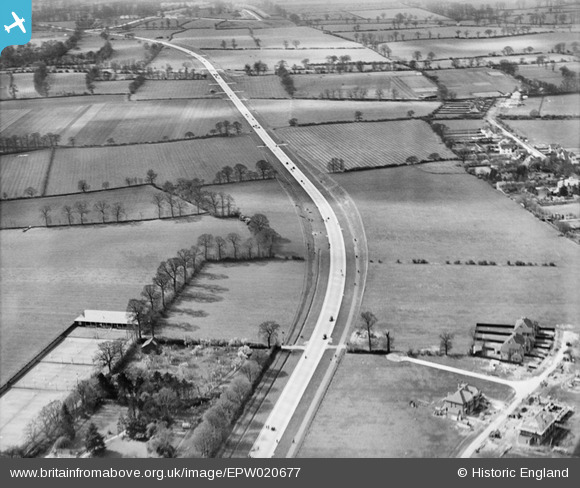
EPW020677 ENGLAND (1928). The Kingston Bypass, Old Malden, 1928
© Copyright OpenStreetMap contributors and licensed by the OpenStreetMap Foundation. 2025. Cartography is licensed as CC BY-SA.
Nearby Images (3)
EPW020677

EPW017146

EPW017336

Details
| Title | [EPW020677] The Kingston Bypass, Old Malden, 1928 |
| Reference | EPW020677 |
| Date | March-1928 |
| Link | |
| Place name | OLD MALDEN |
| Parish | |
| District | |
| Country | ENGLAND |
| Easting / Northing | 521238, 167446 |
| Longitude / Latitude | -0.2572419684707, 51.392587465258 |
| National Grid Reference | TQ212674 |
Pins
 mike |
Saturday 28th of June 2014 05:34:19 PM | |
Hello, This hedge line is not South Lane it is actually the next one away from the camera. If that line is followed to the right, the intersection with Thetford Road can be seen. |
Matt |
Wednesday 25th of May 2016 03:20:24 PM |
mike |
Saturday 1st of February 2014 06:35:09 PM | |
 Maurice |
Wednesday 23rd of January 2013 08:46:54 AM | |
Maurice |
Wednesday 23rd of January 2013 08:46:27 AM |
User Comment Contributions
The Ribbon Development Act of 1935 attempted to stop linear development along main roads but it came too late for many of the fairly tightly packed housing built up to and beyond bypasses. |
Maurice |
Wednesday 25th of May 2016 03:27:44 PM |
The building in this area was rigorously controlled by The Maldens and Coombe District Council. Their Town Planning Scheme designated areas for specific types of development and as a result the transition of the ancient parish of Malden to a dormitory left us with a great deal of green space and limited housing densities. While it was built upon, we owe a debt of thanks to the forward thinking of the council which avoided it becoming like Wimbledon or Merton. |
Matt |
Wednesday 25th of May 2016 03:27:44 PM |