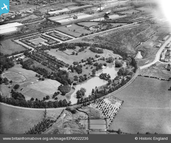
EPW022236 ENGLAND (1928). Queen's Park and the Crewe Works, Crewe, 1928
© Copyright OpenStreetMap contributors and licensed by the OpenStreetMap Foundation. 2025. Cartography is licensed as CC BY-SA.
Nearby Images (13)
Details
| Title | [EPW022236] Queen's Park and the Crewe Works, Crewe, 1928 |
| Reference | EPW022236 |
| Date | 31-July-1928 |
| Link | |
| Place name | CREWE |
| Parish | |
| District | |
| Country | ENGLAND |
| Easting / Northing | 368776, 355593 |
| Longitude / Latitude | -2.4663482617609, 53.096329823716 |
| National Grid Reference | SJ688556 |
Pins
 Crewedaddy |
Wednesday 13th of September 2017 12:25:42 AM | |
 Creweboy |
Sunday 17th of January 2016 01:33:58 PM |


![[EPW022236] Queen's Park and the Crewe Works, Crewe, 1928](http://britainfromabove.org.uk/sites/all/libraries/aerofilms-images/public/100x100/EPW/022/EPW022236.jpg)
![[EPW023572] Queen's Park, Crewe, 1928](http://britainfromabove.org.uk/sites/all/libraries/aerofilms-images/public/100x100/EPW/023/EPW023572.jpg)
![[EPW022233] Queen's Park and the Crewe Works, Crewe, 1928](http://britainfromabove.org.uk/sites/all/libraries/aerofilms-images/public/100x100/EPW/022/EPW022233.jpg)
![[EPW022231] Queen's Park, Crewe, 1928](http://britainfromabove.org.uk/sites/all/libraries/aerofilms-images/public/100x100/EPW/022/EPW022231.jpg)
![[EPW022232] Queen's Park and the Crewe Works, Crewe, 1928](http://britainfromabove.org.uk/sites/all/libraries/aerofilms-images/public/100x100/EPW/022/EPW022232.jpg)
![[EPW023574] Queen's Park, Crewe, 1928](http://britainfromabove.org.uk/sites/all/libraries/aerofilms-images/public/100x100/EPW/023/EPW023574.jpg)
![[EPW023573] Queen's Park, Crewe, 1928](http://britainfromabove.org.uk/sites/all/libraries/aerofilms-images/public/100x100/EPW/023/EPW023573.jpg)
![[EPW023576] Queen's Park, Crewe, 1928](http://britainfromabove.org.uk/sites/all/libraries/aerofilms-images/public/100x100/EPW/023/EPW023576.jpg)
![[EPW022234] Queen's Park and environs, Crewe, 1928](http://britainfromabove.org.uk/sites/all/libraries/aerofilms-images/public/100x100/EPW/022/EPW022234.jpg)
![[EPW023575] Queen's Park, Crewe, 1928](http://britainfromabove.org.uk/sites/all/libraries/aerofilms-images/public/100x100/EPW/023/EPW023575.jpg)
![[EPW022235] Queen's Park and the Crewe Works, Crewe, 1928](http://britainfromabove.org.uk/sites/all/libraries/aerofilms-images/public/100x100/EPW/022/EPW022235.jpg)
![[EPW022238] Queen's Park, Crewe, 1928](http://britainfromabove.org.uk/sites/all/libraries/aerofilms-images/public/100x100/EPW/022/EPW022238.jpg)
![[EPW022237] Queen's Park, Crewe, 1928](http://britainfromabove.org.uk/sites/all/libraries/aerofilms-images/public/100x100/EPW/022/EPW022237.jpg)