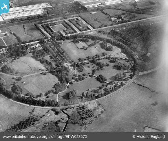
EPW023572 ENGLAND (1928). Queen's Park, Crewe, 1928
© Copyright OpenStreetMap contributors and licensed by the OpenStreetMap Foundation. 2025. Cartography is licensed as CC BY-SA.
Nearby Images (13)
Details
| Title | [EPW023572] Queen's Park, Crewe, 1928 |
| Reference | EPW023572 |
| Date | September-1928 |
| Link | |
| Place name | CREWE |
| Parish | |
| District | |
| Country | ENGLAND |
| Easting / Northing | 368776, 355598 |
| Longitude / Latitude | -2.4663487478008, 53.096374772583 |
| National Grid Reference | SJ688556 |
Pins
 Martin |
Sunday 19th of January 2014 10:21:14 PM |


![[EPW023572] Queen's Park, Crewe, 1928](http://britainfromabove.org.uk/sites/all/libraries/aerofilms-images/public/100x100/EPW/023/EPW023572.jpg)
![[EPW022236] Queen's Park and the Crewe Works, Crewe, 1928](http://britainfromabove.org.uk/sites/all/libraries/aerofilms-images/public/100x100/EPW/022/EPW022236.jpg)
![[EPW022233] Queen's Park and the Crewe Works, Crewe, 1928](http://britainfromabove.org.uk/sites/all/libraries/aerofilms-images/public/100x100/EPW/022/EPW022233.jpg)
![[EPW022231] Queen's Park, Crewe, 1928](http://britainfromabove.org.uk/sites/all/libraries/aerofilms-images/public/100x100/EPW/022/EPW022231.jpg)
![[EPW022232] Queen's Park and the Crewe Works, Crewe, 1928](http://britainfromabove.org.uk/sites/all/libraries/aerofilms-images/public/100x100/EPW/022/EPW022232.jpg)
![[EPW023574] Queen's Park, Crewe, 1928](http://britainfromabove.org.uk/sites/all/libraries/aerofilms-images/public/100x100/EPW/023/EPW023574.jpg)
![[EPW023573] Queen's Park, Crewe, 1928](http://britainfromabove.org.uk/sites/all/libraries/aerofilms-images/public/100x100/EPW/023/EPW023573.jpg)
![[EPW023576] Queen's Park, Crewe, 1928](http://britainfromabove.org.uk/sites/all/libraries/aerofilms-images/public/100x100/EPW/023/EPW023576.jpg)
![[EPW022235] Queen's Park and the Crewe Works, Crewe, 1928](http://britainfromabove.org.uk/sites/all/libraries/aerofilms-images/public/100x100/EPW/022/EPW022235.jpg)
![[EPW022234] Queen's Park and environs, Crewe, 1928](http://britainfromabove.org.uk/sites/all/libraries/aerofilms-images/public/100x100/EPW/022/EPW022234.jpg)
![[EPW023575] Queen's Park, Crewe, 1928](http://britainfromabove.org.uk/sites/all/libraries/aerofilms-images/public/100x100/EPW/023/EPW023575.jpg)
![[EPW022238] Queen's Park, Crewe, 1928](http://britainfromabove.org.uk/sites/all/libraries/aerofilms-images/public/100x100/EPW/022/EPW022238.jpg)
![[EPW022237] Queen's Park, Crewe, 1928](http://britainfromabove.org.uk/sites/all/libraries/aerofilms-images/public/100x100/EPW/022/EPW022237.jpg)