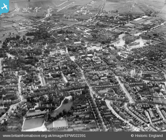
EPW022391 ENGLAND (1928). The town centre, Bedford, 1928.
© Copyright OpenStreetMap contributors and licensed by the OpenStreetMap Foundation. 2025. Cartography is licensed as CC BY-SA.
Nearby Images (31)
Details
| Title | [EPW022391] The town centre, Bedford, 1928. |
| Reference | EPW022391 |
| Date | 9-August-1928 |
| Link | |
| Place name | BEDFORD |
| Parish | |
| District | |
| Country | ENGLAND |
| Easting / Northing | 505018, 249821 |
| Longitude / Latitude | -0.46539592703178, 52.136284797518 |
| National Grid Reference | TL050498 |
Pins
 misterjohn |
Wednesday 21st of December 2022 05:36:54 PM | |
 misterjohn |
Wednesday 21st of December 2022 05:35:52 PM | |
 misterjohn |
Wednesday 21st of December 2022 05:34:33 PM | |
 Class31 |
Sunday 22nd of March 2015 08:10:43 PM | |
 Class31 |
Sunday 22nd of March 2015 08:09:42 PM | |
 Class31 |
Sunday 22nd of March 2015 08:08:57 PM | |
 melgibbs |
Friday 6th of February 2015 07:53:12 PM | |
 melgibbs |
Friday 22nd of November 2013 08:51:22 PM | |
 melgibbs |
Friday 22nd of November 2013 08:50:27 PM | |
 melgibbs |
Friday 22nd of November 2013 08:49:32 PM | |
 melgibbs |
Friday 22nd of November 2013 08:48:49 PM | |
 melgibbs |
Friday 22nd of November 2013 08:47:21 PM | |
 melgibbs |
Saturday 15th of June 2013 06:43:19 PM | |
 melgibbs |
Saturday 15th of June 2013 06:42:20 PM |
User Comment Contributions
From the north |
 G Shortell |
Friday 6th of July 2012 04:40:05 PM |


![[EPW022391] The town centre, Bedford, 1928.](http://britainfromabove.org.uk/sites/all/libraries/aerofilms-images/public/100x100/EPW/022/EPW022391.jpg)
![[EPW045603] St Paul's Church, the High Street and environs, Bedford, 1934. This image has been produced from a copy-negative.](http://britainfromabove.org.uk/sites/all/libraries/aerofilms-images/public/100x100/EPW/045/EPW045603.jpg)
![[EAW049226] The town centre, Bedford, 1953](http://britainfromabove.org.uk/sites/all/libraries/aerofilms-images/public/100x100/EAW/049/EAW049226.jpg)
![[EAW037749] Howard Street and environs, Bedford, 1951. This image was marked by Aerofilms Ltd for photo editing.](http://britainfromabove.org.uk/sites/all/libraries/aerofilms-images/public/100x100/EAW/037/EAW037749.jpg)
![[EAW037746] Howard Street and environs, Bedford, 1951. This image was marked by Aerofilms Ltd for photo editing.](http://britainfromabove.org.uk/sites/all/libraries/aerofilms-images/public/100x100/EAW/037/EAW037746.jpg)
![[EAW037748] Howard Street and environs, Bedford, 1951. This image was marked by Aerofilms Ltd for photo editing.](http://britainfromabove.org.uk/sites/all/libraries/aerofilms-images/public/100x100/EAW/037/EAW037748.jpg)
![[EPW026472] St Paul's Church and the town centre, Bedford, 1929](http://britainfromabove.org.uk/sites/all/libraries/aerofilms-images/public/100x100/EPW/026/EPW026472.jpg)
![[EPW046439] The town centre, Bedford, 1934](http://britainfromabove.org.uk/sites/all/libraries/aerofilms-images/public/100x100/EPW/046/EPW046439.jpg)
![[EAW049227] The town centre, Bedford, 1953](http://britainfromabove.org.uk/sites/all/libraries/aerofilms-images/public/100x100/EAW/049/EAW049227.jpg)
![[EPW026465] St Paul's Church, Bedford, 1929](http://britainfromabove.org.uk/sites/all/libraries/aerofilms-images/public/100x100/EPW/026/EPW026465.jpg)
![[EPW022388] St Paul's Church and the town centre, Bedford, from the north-west, 1928. This image has been affected by flare.](http://britainfromabove.org.uk/sites/all/libraries/aerofilms-images/public/100x100/EPW/022/EPW022388.jpg)
![[EAW037745] Howard Street and environs, Bedford, 1951. This image was marked by Aerofilms Ltd for photo editing.](http://britainfromabove.org.uk/sites/all/libraries/aerofilms-images/public/100x100/EAW/037/EAW037745.jpg)
![[EAW037744] Howard Street and environs, Bedford, 1951. This image was marked by Aerofilms Ltd for photo editing.](http://britainfromabove.org.uk/sites/all/libraries/aerofilms-images/public/100x100/EAW/037/EAW037744.jpg)
![[EAW037747] Howard Street and environs, Bedford, 1951. This image was marked by Aerofilms Ltd for photo editing.](http://britainfromabove.org.uk/sites/all/libraries/aerofilms-images/public/100x100/EAW/037/EAW037747.jpg)
![[EAW003718] The River Great Ouse in flood around Bedford Bridge, Bedford, from the north-west, 1947](http://britainfromabove.org.uk/sites/all/libraries/aerofilms-images/public/100x100/EAW/003/EAW003718.jpg)
![[EPW046435] The town centre, Bedford, 1934](http://britainfromabove.org.uk/sites/all/libraries/aerofilms-images/public/100x100/EPW/046/EPW046435.jpg)
![[EPW030066] The R101 airship on its first test flight, Bedford, from the south-east, 1929](http://britainfromabove.org.uk/sites/all/libraries/aerofilms-images/public/100x100/EPW/030/EPW030066.jpg)
![[EPW026461] St Paul's Church and the town centre, Bedford, 1929](http://britainfromabove.org.uk/sites/all/libraries/aerofilms-images/public/100x100/EPW/026/EPW026461.jpg)
![[EAW037763] Gadsby Street and environs, Bedford, 1951. This image was marked by Aerofilms Ltd for photo editing.](http://britainfromabove.org.uk/sites/all/libraries/aerofilms-images/public/100x100/EAW/037/EAW037763.jpg)
![[EAW037738] Bunyan Meeting and environs, Bedford, 1951. This image was marked by Aerofilms Ltd for photo editing.](http://britainfromabove.org.uk/sites/all/libraries/aerofilms-images/public/100x100/EAW/037/EAW037738.jpg)
![[EAW037740] Bunyan Meeting and environs, Bedford, 1951. This image was marked by Aerofilms Ltd for photo editing.](http://britainfromabove.org.uk/sites/all/libraries/aerofilms-images/public/100x100/EAW/037/EAW037740.jpg)
![[EPW022386] St Paul's Church and the town centre, Bedford, 1928.](http://britainfromabove.org.uk/sites/all/libraries/aerofilms-images/public/100x100/EPW/022/EPW022386.jpg)
![[EAW037739] Bunyan Meeting and environs, Bedford, 1951. This image was marked by Aerofilms Ltd for photo editing.](http://britainfromabove.org.uk/sites/all/libraries/aerofilms-images/public/100x100/EAW/037/EAW037739.jpg)
![[EPW022383] St Paul's Church and the Bedford Bridge, Bedford, 1928.](http://britainfromabove.org.uk/sites/all/libraries/aerofilms-images/public/100x100/EPW/022/EPW022383.jpg)
![[EAW037743] Bunyan Meeting and environs, Bedford, 1951. This image was marked by Aerofilms Ltd for photo editing.](http://britainfromabove.org.uk/sites/all/libraries/aerofilms-images/public/100x100/EAW/037/EAW037743.jpg)
![[EAW037742] Bunyan Meeting and environs, Bedford, 1951. This image was marked by Aerofilms Ltd for photo editing.](http://britainfromabove.org.uk/sites/all/libraries/aerofilms-images/public/100x100/EAW/037/EAW037742.jpg)
![[EAW037741] Bunyan Meeting and environs, Bedford, 1951. This image was marked by Aerofilms Ltd for photo editing.](http://britainfromabove.org.uk/sites/all/libraries/aerofilms-images/public/100x100/EAW/037/EAW037741.jpg)
![[EAW037760] Bunyan Meeting and environs, Bedford, 1951. This image was marked by Aerofilms Ltd for photo editing.](http://britainfromabove.org.uk/sites/all/libraries/aerofilms-images/public/100x100/EAW/037/EAW037760.jpg)
![[EPW022387] St Paul's Church and the town centre, Bedford, 1928.](http://britainfromabove.org.uk/sites/all/libraries/aerofilms-images/public/100x100/EPW/022/EPW022387.jpg)
![[EAW037761] Bunyan Meeting and environs, Bedford, 1951. This image was marked by Aerofilms Ltd for photo editing.](http://britainfromabove.org.uk/sites/all/libraries/aerofilms-images/public/100x100/EAW/037/EAW037761.jpg)
![[EPW022379] The town centre, Bedford, 1928](http://britainfromabove.org.uk/sites/all/libraries/aerofilms-images/public/100x100/EPW/022/EPW022379.jpg)