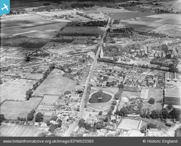
EPW023383 ENGLAND (1928). The High Street and town centre, Feltham, 1928
© Copyright OpenStreetMap contributors and licensed by the OpenStreetMap Foundation. 2025. Cartography is licensed as CC BY-SA.
Nearby Images (5)
Details
| Title | [EPW023383] The High Street and town centre, Feltham, 1928 |
| Reference | EPW023383 |
| Date | September-1928 |
| Link | |
| Place name | FELTHAM |
| Parish | |
| District | |
| Country | ENGLAND |
| Easting / Northing | 510608, 173151 |
| Longitude / Latitude | -0.40819773644301, 51.446042907268 |
| National Grid Reference | TQ106732 |
Pins
 CJC |
Tuesday 27th of April 2021 08:54:40 PM | |
 waylou |
Wednesday 21st of April 2021 06:12:26 PM | |
 Captain MC |
Saturday 7th of December 2013 12:17:27 AM | |
 eribann |
Friday 3rd of May 2013 09:52:14 PM | |
 eribann |
Friday 3rd of May 2013 09:50:03 PM | |
 John |
Friday 13th of July 2012 11:47:31 PM | |
 John |
Friday 13th of July 2012 11:45:39 PM | |
Now Cardinal Infants School |
 librarian |
Tuesday 11th of December 2012 04:10:00 PM |
 John |
Friday 13th of July 2012 11:44:07 PM | |
 Jon |
Wednesday 27th of June 2012 09:51:48 PM | |
 AdrianB |
Wednesday 27th of June 2012 02:18:43 PM | |
 AdrianB |
Wednesday 27th of June 2012 02:08:03 PM | |
 Roy Cousins |
Wednesday 27th of June 2012 11:17:29 AM | |
Yes, see map at http://en.wikipedia.org/wiki/London_Air_Park |
 Peter Heston |
Sunday 1st of July 2012 02:48:41 PM |


![[EPW023383] The High Street and town centre, Feltham, 1928](http://britainfromabove.org.uk/sites/all/libraries/aerofilms-images/public/100x100/EPW/023/EPW023383.jpg)
![[EPW023382] Feltham Railway Station and environs, Feltham, 1928](http://britainfromabove.org.uk/sites/all/libraries/aerofilms-images/public/100x100/EPW/023/EPW023382.jpg)
![[EPW053968] High Street and environs, Feltham, 1937. This image has been produced from a copy-negative.](http://britainfromabove.org.uk/sites/all/libraries/aerofilms-images/public/100x100/EPW/053/EPW053968.jpg)
![[EAW042317] Hounslow Road and the High Street, Feltham, 1952. This image has been produced from a damaged negative.](http://britainfromabove.org.uk/sites/all/libraries/aerofilms-images/public/100x100/EAW/042/EAW042317.jpg)
![[EAW042321] J.A. Parker Ltd Saw Mills and environs, Feltham, 1952. This image has been produced from a print marked by Aerofilms Ltd for photo editing.](http://britainfromabove.org.uk/sites/all/libraries/aerofilms-images/public/100x100/EAW/042/EAW042321.jpg)