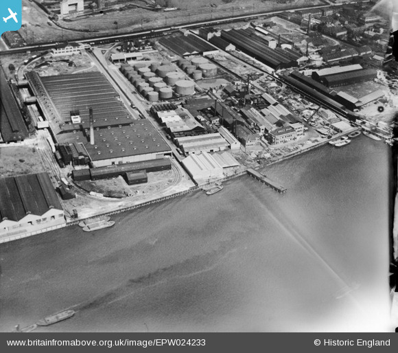
EPW024233 ENGLAND (1928). Minoco Wharf and environs, Silvertown, 1928
© Copyright OpenStreetMap contributors and licensed by the OpenStreetMap Foundation. 2025. Cartography is licensed as CC BY-SA.
Nearby Images (27)
Details
| Title | [EPW024233] Minoco Wharf and environs, Silvertown, 1928 |
| Reference | EPW024233 |
| Date | September-1928 |
| Link | |
| Place name | SILVERTOWN |
| Parish | |
| District | |
| Country | ENGLAND |
| Easting / Northing | 540926, 179743 |
| Longitude / Latitude | 0.030487066243933, 51.498551294938 |
| National Grid Reference | TQ409797 |
Pins
 Class31 |
Thursday 19th of February 2015 10:22:55 AM |


![[EPW024233] Minoco Wharf and environs, Silvertown, 1928](http://britainfromabove.org.uk/sites/all/libraries/aerofilms-images/public/100x100/EPW/024/EPW024233.jpg)
![[EPW024230] Minoco Wharf and environs, Silvertown, 1928](http://britainfromabove.org.uk/sites/all/libraries/aerofilms-images/public/100x100/EPW/024/EPW024230.jpg)
![[EPW024239] Minoco Wharf and environs, Silvertown, 1928](http://britainfromabove.org.uk/sites/all/libraries/aerofilms-images/public/100x100/EPW/024/EPW024239.jpg)
![[EPW024232] Minoco Wharf and environs, Silvertown, 1928](http://britainfromabove.org.uk/sites/all/libraries/aerofilms-images/public/100x100/EPW/024/EPW024232.jpg)
![[EPW024236] Minoco Wharf and environs with the Royal Victoria Dock in the background, Silvertown, 1928](http://britainfromabove.org.uk/sites/all/libraries/aerofilms-images/public/100x100/EPW/024/EPW024236.jpg)
![[EPW024231] Minoco Wharf and environs, Silvertown, 1928](http://britainfromabove.org.uk/sites/all/libraries/aerofilms-images/public/100x100/EPW/024/EPW024231.jpg)
![[EPW024237] Minoco Wharf and environs with the Royal Victoria Dock in the background, Silvertown, 1928](http://britainfromabove.org.uk/sites/all/libraries/aerofilms-images/public/100x100/EPW/024/EPW024237.jpg)
![[EPW024241] Minoco Wharf and environs, Silvertown, 1928](http://britainfromabove.org.uk/sites/all/libraries/aerofilms-images/public/100x100/EPW/024/EPW024241.jpg)
![[EPW024238] Minoco Wharf and environs, Silvertown, 1928](http://britainfromabove.org.uk/sites/all/libraries/aerofilms-images/public/100x100/EPW/024/EPW024238.jpg)
![[EPW009698] Minoco Wharf, Silvertown, 1923](http://britainfromabove.org.uk/sites/all/libraries/aerofilms-images/public/100x100/EPW/009/EPW009698.jpg)
![[EPW024234] Minoco Wharf and environs, Silvertown, 1928](http://britainfromabove.org.uk/sites/all/libraries/aerofilms-images/public/100x100/EPW/024/EPW024234.jpg)
![[EPW009696] Minoco Wharf, Silvertown, 1923](http://britainfromabove.org.uk/sites/all/libraries/aerofilms-images/public/100x100/EPW/009/EPW009696.jpg)
![[EPW009693] Minoco Wharf, Silvertown, 1923](http://britainfromabove.org.uk/sites/all/libraries/aerofilms-images/public/100x100/EPW/009/EPW009693.jpg)
![[EPW009695] Minoco Wharf, Silvertown, 1923](http://britainfromabove.org.uk/sites/all/libraries/aerofilms-images/public/100x100/EPW/009/EPW009695.jpg)
![[EPW009694] Minoco Wharf, Silvertown, 1923](http://britainfromabove.org.uk/sites/all/libraries/aerofilms-images/public/100x100/EPW/009/EPW009694.jpg)
![[EAW034526] The Venesta and Crescent Wharves, Silvertown, 1951. This image was marked by Aerofilms Ltd for photo editing.](http://britainfromabove.org.uk/sites/all/libraries/aerofilms-images/public/100x100/EAW/034/EAW034526.jpg)
![[EAW034519] Venesta Ltd Box, Barrel and Case Works at Venesta Wharf and environs, Silvertown, 1951. This image was marked by Aerofilms Ltd for photo editing.](http://britainfromabove.org.uk/sites/all/libraries/aerofilms-images/public/100x100/EAW/034/EAW034519.jpg)
![[EPW024235] Minoco Wharf and environs, Silvertown, 1928](http://britainfromabove.org.uk/sites/all/libraries/aerofilms-images/public/100x100/EPW/024/EPW024235.jpg)
![[EAW021112] A cityscape over the River Thames and the Royal Victoria Dock, Silvertown, 1949. This image has been produced from a print.](http://britainfromabove.org.uk/sites/all/libraries/aerofilms-images/public/100x100/EAW/021/EAW021112.jpg)
![[EPW006144] Industrial buildings and wharfage, Silvertown, 1921](http://britainfromabove.org.uk/sites/all/libraries/aerofilms-images/public/100x100/EPW/006/EPW006144.jpg)
![[EAW034528] The Venesta and Crescent Wharves, Silvertown, 1951. This image has been produced from a damaged negative.](http://britainfromabove.org.uk/sites/all/libraries/aerofilms-images/public/100x100/EAW/034/EAW034528.jpg)
![[EAW034521] Lyle Park, and the Venesta and Crescent Wharves, Silvertown, 1951. This image was marked by Aerofilms Ltd for photo editing.](http://britainfromabove.org.uk/sites/all/libraries/aerofilms-images/public/100x100/EAW/034/EAW034521.jpg)
![[EAW034518] The Venesta and Crescent Wharves, Silvertown, 1951. This image was marked by Aerofilms Ltd for photo editing.](http://britainfromabove.org.uk/sites/all/libraries/aerofilms-images/public/100x100/EAW/034/EAW034518.jpg)
![[EAW034520] Venesta Ltd Box, Barrel and Case Works at Venesta Wharf and environs, Silvertown, 1951. This image was marked by Aerofilms Ltd for photo editing.](http://britainfromabove.org.uk/sites/all/libraries/aerofilms-images/public/100x100/EAW/034/EAW034520.jpg)
![[EAW034523] Venesta Ltd Box, Barrel and Case Works at Venesta Wharf and environs, Silvertown, 1951. This image was marked by Aerofilms Ltd for photo editing.](http://britainfromabove.org.uk/sites/all/libraries/aerofilms-images/public/100x100/EAW/034/EAW034523.jpg)
![[EAW034525] The Venesta and Crescent Wharves, Silvertown, 1951. This image was marked by Aerofilms Ltd for photo editing.](http://britainfromabove.org.uk/sites/all/libraries/aerofilms-images/public/100x100/EAW/034/EAW034525.jpg)
![[EAW034522] Venesta Ltd Box, Barrel and Case Works at Venesta Wharf, Silvertown, 1951](http://britainfromabove.org.uk/sites/all/libraries/aerofilms-images/public/100x100/EAW/034/EAW034522.jpg)