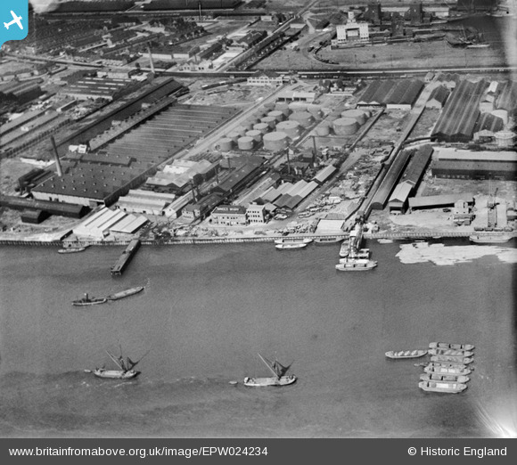
EPW024234 ENGLAND (1928). Minoco Wharf and environs, Silvertown, 1928
© Copyright OpenStreetMap contributors and licensed by the OpenStreetMap Foundation. 2025. Cartography is licensed as CC BY-SA.
Nearby Images (19)
Details
| Title | [EPW024234] Minoco Wharf and environs, Silvertown, 1928 |
| Reference | EPW024234 |
| Date | September-1928 |
| Link | |
| Place name | SILVERTOWN |
| Parish | |
| District | |
| Country | ENGLAND |
| Easting / Northing | 541018, 179733 |
| Longitude / Latitude | 0.031807725044538, 51.498438479072 |
| National Grid Reference | TQ410797 |


![[EPW024234] Minoco Wharf and environs, Silvertown, 1928](http://britainfromabove.org.uk/sites/all/libraries/aerofilms-images/public/100x100/EPW/024/EPW024234.jpg)
![[EPW024241] Minoco Wharf and environs, Silvertown, 1928](http://britainfromabove.org.uk/sites/all/libraries/aerofilms-images/public/100x100/EPW/024/EPW024241.jpg)
![[EPW024231] Minoco Wharf and environs, Silvertown, 1928](http://britainfromabove.org.uk/sites/all/libraries/aerofilms-images/public/100x100/EPW/024/EPW024231.jpg)
![[EPW024236] Minoco Wharf and environs with the Royal Victoria Dock in the background, Silvertown, 1928](http://britainfromabove.org.uk/sites/all/libraries/aerofilms-images/public/100x100/EPW/024/EPW024236.jpg)
![[EPW024232] Minoco Wharf and environs, Silvertown, 1928](http://britainfromabove.org.uk/sites/all/libraries/aerofilms-images/public/100x100/EPW/024/EPW024232.jpg)
![[EPW024238] Minoco Wharf and environs, Silvertown, 1928](http://britainfromabove.org.uk/sites/all/libraries/aerofilms-images/public/100x100/EPW/024/EPW024238.jpg)
![[EPW024237] Minoco Wharf and environs with the Royal Victoria Dock in the background, Silvertown, 1928](http://britainfromabove.org.uk/sites/all/libraries/aerofilms-images/public/100x100/EPW/024/EPW024237.jpg)
![[EPW024239] Minoco Wharf and environs, Silvertown, 1928](http://britainfromabove.org.uk/sites/all/libraries/aerofilms-images/public/100x100/EPW/024/EPW024239.jpg)
![[EPW009696] Minoco Wharf, Silvertown, 1923](http://britainfromabove.org.uk/sites/all/libraries/aerofilms-images/public/100x100/EPW/009/EPW009696.jpg)
![[EPW024233] Minoco Wharf and environs, Silvertown, 1928](http://britainfromabove.org.uk/sites/all/libraries/aerofilms-images/public/100x100/EPW/024/EPW024233.jpg)
![[EPW024230] Minoco Wharf and environs, Silvertown, 1928](http://britainfromabove.org.uk/sites/all/libraries/aerofilms-images/public/100x100/EPW/024/EPW024230.jpg)
![[EPW009693] Minoco Wharf, Silvertown, 1923](http://britainfromabove.org.uk/sites/all/libraries/aerofilms-images/public/100x100/EPW/009/EPW009693.jpg)
![[EPW009698] Minoco Wharf, Silvertown, 1923](http://britainfromabove.org.uk/sites/all/libraries/aerofilms-images/public/100x100/EPW/009/EPW009698.jpg)
![[EPW024235] Minoco Wharf and environs, Silvertown, 1928](http://britainfromabove.org.uk/sites/all/libraries/aerofilms-images/public/100x100/EPW/024/EPW024235.jpg)
![[EPW009694] Minoco Wharf, Silvertown, 1923](http://britainfromabove.org.uk/sites/all/libraries/aerofilms-images/public/100x100/EPW/009/EPW009694.jpg)
![[EPW009695] Minoco Wharf, Silvertown, 1923](http://britainfromabove.org.uk/sites/all/libraries/aerofilms-images/public/100x100/EPW/009/EPW009695.jpg)
![[EPW024240] Minoco Wharf and environs with the Royal Victoria Dock in the background, Silvertown, 1928](http://britainfromabove.org.uk/sites/all/libraries/aerofilms-images/public/100x100/EPW/024/EPW024240.jpg)
![[EAW021112] A cityscape over the River Thames and the Royal Victoria Dock, Silvertown, 1949. This image has been produced from a print.](http://britainfromabove.org.uk/sites/all/libraries/aerofilms-images/public/100x100/EAW/021/EAW021112.jpg)
![[EPW006144] Industrial buildings and wharfage, Silvertown, 1921](http://britainfromabove.org.uk/sites/all/libraries/aerofilms-images/public/100x100/EPW/006/EPW006144.jpg)
