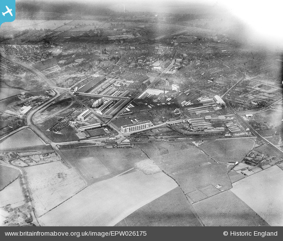
EPW026175 ENGLAND (1929). The British Insulated Cable Works and the town, Prescot, from the south-east, 1929
© Copyright OpenStreetMap contributors and licensed by the OpenStreetMap Foundation. 2025. Cartography is licensed as CC BY-SA.
Nearby Images (26)
Details
| Title | [EPW026175] The British Insulated Cable Works and the town, Prescot, from the south-east, 1929 |
| Reference | EPW026175 |
| Date | April-1929 |
| Link | |
| Place name | PRESCOT |
| Parish | PRESCOT |
| District | |
| Country | ENGLAND |
| Easting / Northing | 347131, 392142 |
| Longitude / Latitude | -2.7956763252001, 53.423162095666 |
| National Grid Reference | SJ471921 |
Pins
Be the first to add a comment to this image!


![[EPW026175] The British Insulated Cable Works and the town, Prescot, from the south-east, 1929](http://britainfromabove.org.uk/sites/all/libraries/aerofilms-images/public/100x100/EPW/026/EPW026175.jpg)
![[EAW021950] British Insulated Callender's Cable Works and the town, Prescot, 1949](http://britainfromabove.org.uk/sites/all/libraries/aerofilms-images/public/100x100/EAW/021/EAW021950.jpg)
![[EPW026174] The British Insulated Cable Works and the town, Prescot, from the south-east, 1929](http://britainfromabove.org.uk/sites/all/libraries/aerofilms-images/public/100x100/EPW/026/EPW026174.jpg)
![[EPW026177] The British Insulated Cable Works and the town, Prescot, from the south-east, 1929](http://britainfromabove.org.uk/sites/all/libraries/aerofilms-images/public/100x100/EPW/026/EPW026177.jpg)
![[EAW021951] British Insulated Callender's Cable Works and the town, Prescot, 1949](http://britainfromabove.org.uk/sites/all/libraries/aerofilms-images/public/100x100/EAW/021/EAW021951.jpg)
![[EPW027866] The British Insulated Cable Works and the town, Prescot, 1929. This image has been produced from a damaged negative.](http://britainfromabove.org.uk/sites/all/libraries/aerofilms-images/public/100x100/EPW/027/EPW027866.jpg)
![[EAW017344] The British Insulated Callender's Cable Works, Prescot, from the east, 1948. This image has been produced from a print.](http://britainfromabove.org.uk/sites/all/libraries/aerofilms-images/public/100x100/EAW/017/EAW017344.jpg)
![[EPW027865] The British Insulated Cable Works and the town, Prescot, 1929. This image has been produced from a damaged negative.](http://britainfromabove.org.uk/sites/all/libraries/aerofilms-images/public/100x100/EPW/027/EPW027865.jpg)
![[EPW026181] The British Insulated Cable Works and the town, Prescot, 1929](http://britainfromabove.org.uk/sites/all/libraries/aerofilms-images/public/100x100/EPW/026/EPW026181.jpg)
![[EPW027864] The British Insulated Cable Works and the town, Prescot, 1929. This image has been affected by flare.](http://britainfromabove.org.uk/sites/all/libraries/aerofilms-images/public/100x100/EPW/027/EPW027864.jpg)
![[EPW054342] The British Insulated Cable Works, Prescot, 1937](http://britainfromabove.org.uk/sites/all/libraries/aerofilms-images/public/100x100/EPW/054/EPW054342.jpg)
![[EAW021947] British Insulated Callender's Cable Works, Prescot, 1949](http://britainfromabove.org.uk/sites/all/libraries/aerofilms-images/public/100x100/EAW/021/EAW021947.jpg)
![[EPW026180] The British Insulated Cable Works, Prescot, 1929](http://britainfromabove.org.uk/sites/all/libraries/aerofilms-images/public/100x100/EPW/026/EPW026180.jpg)
![[EAW017346] The British Insulated Callender's Cable Works, Prescot, from the east, 1948. This image has been produced from a print.](http://britainfromabove.org.uk/sites/all/libraries/aerofilms-images/public/100x100/EAW/017/EAW017346.jpg)
![[EPW025208] British Insulated Cable Works and environs, Prescot, 1928](http://britainfromabove.org.uk/sites/all/libraries/aerofilms-images/public/100x100/EPW/025/EPW025208.jpg)
![[EAW021939] British Insulated Callender's Cables Ltd Works and the town, Prescot, 1949](http://britainfromabove.org.uk/sites/all/libraries/aerofilms-images/public/100x100/EAW/021/EAW021939.jpg)
![[EPW025351] British Insulated Cable Works, Prescot, 1928](http://britainfromabove.org.uk/sites/all/libraries/aerofilms-images/public/100x100/EPW/025/EPW025351.jpg)
![[EPW014159] The British Insulated Cable Works and Prescot Railway Station, Prescot, 1925. This image has been produced from a copy-negative.](http://britainfromabove.org.uk/sites/all/libraries/aerofilms-images/public/100x100/EPW/014/EPW014159.jpg)
![[EPW025352] British Insulated Cable Works, Prescot, 1928](http://britainfromabove.org.uk/sites/all/libraries/aerofilms-images/public/100x100/EPW/025/EPW025352.jpg)
![[EPW026178] The British Insulated Cable Works and the town, Prescot, 1929](http://britainfromabove.org.uk/sites/all/libraries/aerofilms-images/public/100x100/EPW/026/EPW026178.jpg)
![[EAW021942] British Insulated Callender's Cable Works, Prescot, 1949](http://britainfromabove.org.uk/sites/all/libraries/aerofilms-images/public/100x100/EAW/021/EAW021942.jpg)
![[EPW026182] The British Insulated Cable Works and the town, Prescot, 1929](http://britainfromabove.org.uk/sites/all/libraries/aerofilms-images/public/100x100/EPW/026/EPW026182.jpg)
![[EPW053284] The British Insulated Cable Works, Prescot, 1937](http://britainfromabove.org.uk/sites/all/libraries/aerofilms-images/public/100x100/EPW/053/EPW053284.jpg)
![[EPR000627] The British Insulated Cables Ltd Works and environs, Prescot, 1935](http://britainfromabove.org.uk/sites/all/libraries/aerofilms-images/public/100x100/EPR/000/EPR000627.jpg)
![[EAW021948] British Insulated Callender's Cable Works, Prescot, 1949](http://britainfromabove.org.uk/sites/all/libraries/aerofilms-images/public/100x100/EAW/021/EAW021948.jpg)
![[EPW053286] The British Insulated Cable Works, Prescot, 1937](http://britainfromabove.org.uk/sites/all/libraries/aerofilms-images/public/100x100/EPW/053/EPW053286.jpg)