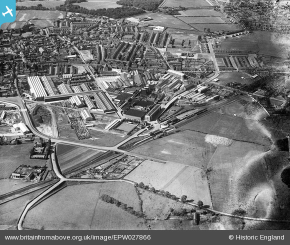
EPW027866 ENGLAND (1929). The British Insulated Cable Works and the town, Prescot, 1929. This image has been produced from a damaged negative.
© Copyright OpenStreetMap contributors and licensed by the OpenStreetMap Foundation. 2025. Cartography is licensed as CC BY-SA.
Nearby Images (48)
Details
| Title | [EPW027866] The British Insulated Cable Works and the town, Prescot, 1929. This image has been produced from a damaged negative. |
| Reference | EPW027866 |
| Date | June-1929 |
| Link | |
| Place name | PRESCOT |
| Parish | PRESCOT |
| District | |
| Country | ENGLAND |
| Easting / Northing | 346974, 392251 |
| Longitude / Latitude | -2.7980572664815, 53.424126101726 |
| National Grid Reference | SJ470923 |
Pins
Be the first to add a comment to this image!


![[EPW027866] The British Insulated Cable Works and the town, Prescot, 1929. This image has been produced from a damaged negative.](http://britainfromabove.org.uk/sites/all/libraries/aerofilms-images/public/100x100/EPW/027/EPW027866.jpg)
![[EPW027865] The British Insulated Cable Works and the town, Prescot, 1929. This image has been produced from a damaged negative.](http://britainfromabove.org.uk/sites/all/libraries/aerofilms-images/public/100x100/EPW/027/EPW027865.jpg)
![[EPW027864] The British Insulated Cable Works and the town, Prescot, 1929. This image has been affected by flare.](http://britainfromabove.org.uk/sites/all/libraries/aerofilms-images/public/100x100/EPW/027/EPW027864.jpg)
![[EPW054342] The British Insulated Cable Works, Prescot, 1937](http://britainfromabove.org.uk/sites/all/libraries/aerofilms-images/public/100x100/EPW/054/EPW054342.jpg)
![[EAW021947] British Insulated Callender's Cable Works, Prescot, 1949](http://britainfromabove.org.uk/sites/all/libraries/aerofilms-images/public/100x100/EAW/021/EAW021947.jpg)
![[EPW026180] The British Insulated Cable Works, Prescot, 1929](http://britainfromabove.org.uk/sites/all/libraries/aerofilms-images/public/100x100/EPW/026/EPW026180.jpg)
![[EPW026181] The British Insulated Cable Works and the town, Prescot, 1929](http://britainfromabove.org.uk/sites/all/libraries/aerofilms-images/public/100x100/EPW/026/EPW026181.jpg)
![[EPW025351] British Insulated Cable Works, Prescot, 1928](http://britainfromabove.org.uk/sites/all/libraries/aerofilms-images/public/100x100/EPW/025/EPW025351.jpg)
![[EAW017346] The British Insulated Callender's Cable Works, Prescot, from the east, 1948. This image has been produced from a print.](http://britainfromabove.org.uk/sites/all/libraries/aerofilms-images/public/100x100/EAW/017/EAW017346.jpg)
![[EPW014159] The British Insulated Cable Works and Prescot Railway Station, Prescot, 1925. This image has been produced from a copy-negative.](http://britainfromabove.org.uk/sites/all/libraries/aerofilms-images/public/100x100/EPW/014/EPW014159.jpg)
![[EPW025352] British Insulated Cable Works, Prescot, 1928](http://britainfromabove.org.uk/sites/all/libraries/aerofilms-images/public/100x100/EPW/025/EPW025352.jpg)
![[EPW026182] The British Insulated Cable Works and the town, Prescot, 1929](http://britainfromabove.org.uk/sites/all/libraries/aerofilms-images/public/100x100/EPW/026/EPW026182.jpg)
![[EAW021942] British Insulated Callender's Cable Works, Prescot, 1949](http://britainfromabove.org.uk/sites/all/libraries/aerofilms-images/public/100x100/EAW/021/EAW021942.jpg)
![[EPW025208] British Insulated Cable Works and environs, Prescot, 1928](http://britainfromabove.org.uk/sites/all/libraries/aerofilms-images/public/100x100/EPW/025/EPW025208.jpg)
![[EPW053284] The British Insulated Cable Works, Prescot, 1937](http://britainfromabove.org.uk/sites/all/libraries/aerofilms-images/public/100x100/EPW/053/EPW053284.jpg)
![[EPW054343] The British Insulated Cable Works, Prescot, 1937](http://britainfromabove.org.uk/sites/all/libraries/aerofilms-images/public/100x100/EPW/054/EPW054343.jpg)
![[EPW026178] The British Insulated Cable Works and the town, Prescot, 1929](http://britainfromabove.org.uk/sites/all/libraries/aerofilms-images/public/100x100/EPW/026/EPW026178.jpg)
![[EPW026179] The British Insulated Cable Works and the town, Prescot, 1929](http://britainfromabove.org.uk/sites/all/libraries/aerofilms-images/public/100x100/EPW/026/EPW026179.jpg)
![[EAW021948] British Insulated Callender's Cable Works, Prescot, 1949](http://britainfromabove.org.uk/sites/all/libraries/aerofilms-images/public/100x100/EAW/021/EAW021948.jpg)
![[EAW017344] The British Insulated Callender's Cable Works, Prescot, from the east, 1948. This image has been produced from a print.](http://britainfromabove.org.uk/sites/all/libraries/aerofilms-images/public/100x100/EAW/017/EAW017344.jpg)
![[EPW053286] The British Insulated Cable Works, Prescot, 1937](http://britainfromabove.org.uk/sites/all/libraries/aerofilms-images/public/100x100/EPW/053/EPW053286.jpg)
![[EPR000625] The British Insulated Cables Ltd Works, Prescot, 1935](http://britainfromabove.org.uk/sites/all/libraries/aerofilms-images/public/100x100/EPR/000/EPR000625.jpg)
![[EPR000627] The British Insulated Cables Ltd Works and environs, Prescot, 1935](http://britainfromabove.org.uk/sites/all/libraries/aerofilms-images/public/100x100/EPR/000/EPR000627.jpg)
![[EAW021943] British Insulated Callender's Cable Works, Prescot, 1949. This image was marked by Aerofilms Ltd for photo editing.](http://britainfromabove.org.uk/sites/all/libraries/aerofilms-images/public/100x100/EAW/021/EAW021943.jpg)
![[EPW053287] The British Insulated Cable Works, Prescot, 1937](http://britainfromabove.org.uk/sites/all/libraries/aerofilms-images/public/100x100/EPW/053/EPW053287.jpg)
![[EPW053288] The British Insulated Cable Works, Prescot, 1937](http://britainfromabove.org.uk/sites/all/libraries/aerofilms-images/public/100x100/EPW/053/EPW053288.jpg)
![[EPW054344] The British Insulated Cable Works, Prescot, 1937](http://britainfromabove.org.uk/sites/all/libraries/aerofilms-images/public/100x100/EPW/054/EPW054344.jpg)
![[EPW025209] British Insulated Cable Works and environs, Prescot, 1928](http://britainfromabove.org.uk/sites/all/libraries/aerofilms-images/public/100x100/EPW/025/EPW025209.jpg)
![[EPR000626] The British Insulated Cables Ltd Works and environs, Prescot, 1935](http://britainfromabove.org.uk/sites/all/libraries/aerofilms-images/public/100x100/EPR/000/EPR000626.jpg)
![[EAW017345] The British Insulated Callender's Cable Works, Prescot, 1948. This image has been produced from a print.](http://britainfromabove.org.uk/sites/all/libraries/aerofilms-images/public/100x100/EAW/017/EAW017345.jpg)
![[EPW025350] British Insulated Cable Works, Prescot, 1928](http://britainfromabove.org.uk/sites/all/libraries/aerofilms-images/public/100x100/EPW/025/EPW025350.jpg)
![[EPW018933] British Insulated Cable Works, Prescot, 1927](http://britainfromabove.org.uk/sites/all/libraries/aerofilms-images/public/100x100/EPW/018/EPW018933.jpg)
![[EPW053289] The British Insulated Cable Works, Prescot, 1937](http://britainfromabove.org.uk/sites/all/libraries/aerofilms-images/public/100x100/EPW/053/EPW053289.jpg)
![[EAW021950] British Insulated Callender's Cable Works and the town, Prescot, 1949](http://britainfromabove.org.uk/sites/all/libraries/aerofilms-images/public/100x100/EAW/021/EAW021950.jpg)
![[EPW026175] The British Insulated Cable Works and the town, Prescot, from the south-east, 1929](http://britainfromabove.org.uk/sites/all/libraries/aerofilms-images/public/100x100/EPW/026/EPW026175.jpg)
![[EPW054341] The British Insulated Cable Works, Prescot, 1937](http://britainfromabove.org.uk/sites/all/libraries/aerofilms-images/public/100x100/EPW/054/EPW054341.jpg)
![[EPW025207] British Insulated Cable Works and environs, Prescot, 1928](http://britainfromabove.org.uk/sites/all/libraries/aerofilms-images/public/100x100/EPW/025/EPW025207.jpg)
![[EPW053285] The British Insulated Cable Works, Prescot, 1937](http://britainfromabove.org.uk/sites/all/libraries/aerofilms-images/public/100x100/EPW/053/EPW053285.jpg)
![[EPW025213] British Insulated Cable Works and environs, Prescot, 1928](http://britainfromabove.org.uk/sites/all/libraries/aerofilms-images/public/100x100/EPW/025/EPW025213.jpg)
![[EAW021951] British Insulated Callender's Cable Works and the town, Prescot, 1949](http://britainfromabove.org.uk/sites/all/libraries/aerofilms-images/public/100x100/EAW/021/EAW021951.jpg)
![[EPW054345] The British Insulated Cable Works and the town, Prescot, 1937. This image has been affected by flare.](http://britainfromabove.org.uk/sites/all/libraries/aerofilms-images/public/100x100/EPW/054/EPW054345.jpg)
![[EPW025206] British Insulated Cable Works and environs, Prescot, 1928](http://britainfromabove.org.uk/sites/all/libraries/aerofilms-images/public/100x100/EPW/025/EPW025206.jpg)
![[EPW054340] The British Insulated Cable Works and the town, Prescot, 1937](http://britainfromabove.org.uk/sites/all/libraries/aerofilms-images/public/100x100/EPW/054/EPW054340.jpg)
![[EPW025210] British Insulated Cable Works and environs, Prescot, 1928](http://britainfromabove.org.uk/sites/all/libraries/aerofilms-images/public/100x100/EPW/025/EPW025210.jpg)
![[EPW026174] The British Insulated Cable Works and the town, Prescot, from the south-east, 1929](http://britainfromabove.org.uk/sites/all/libraries/aerofilms-images/public/100x100/EPW/026/EPW026174.jpg)
![[EPW025205] British Insulated Cable Works and environs, Prescot, 1928](http://britainfromabove.org.uk/sites/all/libraries/aerofilms-images/public/100x100/EPW/025/EPW025205.jpg)
![[EPW026177] The British Insulated Cable Works and the town, Prescot, from the south-east, 1929](http://britainfromabove.org.uk/sites/all/libraries/aerofilms-images/public/100x100/EPW/026/EPW026177.jpg)
![[EAW021941] The town, Prescot, 1949. This image was marked by Aerofilms Ltd for photo editing.](http://britainfromabove.org.uk/sites/all/libraries/aerofilms-images/public/100x100/EAW/021/EAW021941.jpg)