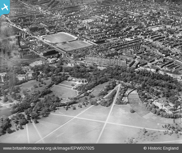
EPW027025 ENGLAND (1929). North Gate, Lord's Cricket Ground and Regent's Park, St John's Wood, 1929
© Copyright OpenStreetMap contributors and licensed by the OpenStreetMap Foundation. 2025. Cartography is licensed as CC BY-SA.
Nearby Images (10)
Details
| Title | [EPW027025] North Gate, Lord's Cricket Ground and Regent's Park, St John's Wood, 1929 |
| Reference | EPW027025 |
| Date | May-1929 |
| Link | |
| Place name | ST JOHN'S WOOD |
| Parish | |
| District | |
| Country | ENGLAND |
| Easting / Northing | 527331, 182964 |
| Longitude / Latitude | -0.16411448781805, 51.530727798245 |
| National Grid Reference | TQ273830 |


![[EPW027025] North Gate, Lord's Cricket Ground and Regent's Park, St John's Wood, 1929](http://britainfromabove.org.uk/sites/all/libraries/aerofilms-images/public/100x100/EPW/027/EPW027025.jpg)
![[EPW027026] North Gate, Lord's Cricket Ground and Regent's Park, St John's Wood, 1929](http://britainfromabove.org.uk/sites/all/libraries/aerofilms-images/public/100x100/EPW/027/EPW027026.jpg)
![[EPW027021] North Gate, Lord's Cricket Ground and Regent's Park, St John's Wood, 1929](http://britainfromabove.org.uk/sites/all/libraries/aerofilms-images/public/100x100/EPW/027/EPW027021.jpg)
![[EPW027023] North Gate, Lord's Cricket Ground and Regent's Park, St John's Wood, 1929](http://britainfromabove.org.uk/sites/all/libraries/aerofilms-images/public/100x100/EPW/027/EPW027023.jpg)
![[EPW027018] North Gate, Lord's Cricket Ground and Regent's Park, St John's Wood, 1929](http://britainfromabove.org.uk/sites/all/libraries/aerofilms-images/public/100x100/EPW/027/EPW027018.jpg)
![[EPW027024] North Gate, Regent's Park and environs, St John's Wood, 1929](http://britainfromabove.org.uk/sites/all/libraries/aerofilms-images/public/100x100/EPW/027/EPW027024.jpg)
![[EPW027022] North Gate, Lord's Cricket Ground and Regent's Park, St John's Wood, 1929](http://britainfromabove.org.uk/sites/all/libraries/aerofilms-images/public/100x100/EPW/027/EPW027022.jpg)
![[EPW027020] North Gate, St John the Baptist's Church and environs, St John's Wood, 1929](http://britainfromabove.org.uk/sites/all/libraries/aerofilms-images/public/100x100/EPW/027/EPW027020.jpg)
![[EPW027019] North Gate, St John the Baptist's Church and environs, St John's Wood, 1929](http://britainfromabove.org.uk/sites/all/libraries/aerofilms-images/public/100x100/EPW/027/EPW027019.jpg)
![[EAW044242] Lord's Cricket Ground, Regent's Park Boating Lake and the surrounding area, St John's Wood, 1952](http://britainfromabove.org.uk/sites/all/libraries/aerofilms-images/public/100x100/EAW/044/EAW044242.jpg)
