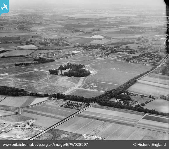
EPW028597 ENGLAND (1929). Hanworth Park Aerodrome (London Air Park) and environs, Hanworth Park, from the east, 1929
© Copyright OpenStreetMap contributors and licensed by the OpenStreetMap Foundation. 2025. Cartography is licensed as CC BY-SA.
Nearby Images (18)
Details
| Title | [EPW028597] Hanworth Park Aerodrome (London Air Park) and environs, Hanworth Park, from the east, 1929 |
| Reference | EPW028597 |
| Date | August-1929 |
| Link | |
| Place name | HANWORTH PARK |
| Parish | |
| District | |
| Country | ENGLAND |
| Easting / Northing | 512004, 172507 |
| Longitude / Latitude | -0.38831968872738, 51.439979541366 |
| National Grid Reference | TQ120725 |
Pins
 GerryOB |
Monday 27th of July 2015 06:59:16 PM | |
 Brian |
Wednesday 11th of February 2015 04:18:16 PM | |
 Brian |
Wednesday 11th of February 2015 04:16:38 PM | |
 Brian |
Tuesday 10th of February 2015 04:52:42 PM | |
 Brian |
Tuesday 10th of February 2015 04:46:14 PM | |
 Brian |
Tuesday 10th of February 2015 04:41:29 PM | |
 Brian |
Monday 9th of February 2015 03:46:24 PM | |
 Brian |
Monday 9th of February 2015 03:44:43 PM | |
 Brian |
Monday 9th of February 2015 03:42:28 PM |


![[EPW028597] Hanworth Park Aerodrome (London Air Park) and environs, Hanworth Park, from the east, 1929](http://britainfromabove.org.uk/sites/all/libraries/aerofilms-images/public/100x100/EPW/028/EPW028597.jpg)
![[EAW023688] The Trianco Boiler Works and the Rex Cinema, Hanworth, 1949](http://britainfromabove.org.uk/sites/all/libraries/aerofilms-images/public/100x100/EAW/023/EAW023688.jpg)
![[EPW044340] Market Parade, Hounslow Road and environs, Hanworth, 1934](http://britainfromabove.org.uk/sites/all/libraries/aerofilms-images/public/100x100/EPW/044/EPW044340.jpg)
![[EPW044343] Uxbridge Road, Hounslow Road and environs, Hanworth Park, 1934](http://britainfromabove.org.uk/sites/all/libraries/aerofilms-images/public/100x100/EPW/044/EPW044343.jpg)
![[EAW023692] The Trianco Boiler Works and Smith's Fireproof Floors Works, Hanworth, 1949. This image was marked by Aerofilms Ltd for photo editing.](http://britainfromabove.org.uk/sites/all/libraries/aerofilms-images/public/100x100/EAW/023/EAW023692.jpg)
![[EAW023685] The Trianco Boiler Works, Hanworth, 1949. This image was marked by Aerofilms Ltd for photo editing.](http://britainfromabove.org.uk/sites/all/libraries/aerofilms-images/public/100x100/EAW/023/EAW023685.jpg)
![[EAW023691] The Trianco Boiler Works and Smith's Fireproof Floors Works, Hanworth, 1949. This image was marked by Aerofilms Ltd for photo editing.](http://britainfromabove.org.uk/sites/all/libraries/aerofilms-images/public/100x100/EAW/023/EAW023691.jpg)
![[EAW023686] The Trianco Boiler Works and Smith's Fireproof Floors Works, Hanworth, 1949. This image was marked by Aerofilms Ltd for photo editing.](http://britainfromabove.org.uk/sites/all/libraries/aerofilms-images/public/100x100/EAW/023/EAW023686.jpg)
![[EPW044345] Woodlawn Drive and environs, Hanworth Park, 1934](http://britainfromabove.org.uk/sites/all/libraries/aerofilms-images/public/100x100/EPW/044/EPW044345.jpg)
![[EAW023690] The Trianco Boiler Works and Smith's Fireproof Floors Works, Hanworth, 1949. This image was marked by Aerofilms Ltd for photo editing.](http://britainfromabove.org.uk/sites/all/libraries/aerofilms-images/public/100x100/EAW/023/EAW023690.jpg)
![[EPW044347] Uxbridge Road, Woodlawn Drive and environs, Hanworth Park, 1934](http://britainfromabove.org.uk/sites/all/libraries/aerofilms-images/public/100x100/EPW/044/EPW044347.jpg)
![[EAW023687] The Trianco Boiler Works and Smith's Fireproof Floors Works, Hanworth, 1949. This image was marked by Aerofilms Ltd for photo editing.](http://britainfromabove.org.uk/sites/all/libraries/aerofilms-images/public/100x100/EAW/023/EAW023687.jpg)
![[EPW044342] Uxbridge Road, Woodlawn Drive and environs, Hanworth Park, 1934](http://britainfromabove.org.uk/sites/all/libraries/aerofilms-images/public/100x100/EPW/044/EPW044342.jpg)
![[EPW044339] Sunningdale Avenue and environs, Hanworth, 1934](http://britainfromabove.org.uk/sites/all/libraries/aerofilms-images/public/100x100/EPW/044/EPW044339.jpg)
![[EPW044338] Sunningdale Avenue and environs, Hanworth, 1934](http://britainfromabove.org.uk/sites/all/libraries/aerofilms-images/public/100x100/EPW/044/EPW044338.jpg)
![[EPW044341] Hounslow Road, Sunningdale Avenue and environs, Hanworth, 1934](http://britainfromabove.org.uk/sites/all/libraries/aerofilms-images/public/100x100/EPW/044/EPW044341.jpg)
![[EPW038818] Hanworth, The Graf Zeppelin (D-LZ127) moored at Hanworth Aerodrome (London Air Park), from the south-east, 1932. This image has been produced from a damaged negative.](http://britainfromabove.org.uk/sites/all/libraries/aerofilms-images/public/100x100/EPW/038/EPW038818.jpg)
![[EAW023689] The Trianco Boiler Works and the surrounding area, Hanworth, 1949. This image was marked by Aerofilms Ltd for photo editing.](http://britainfromabove.org.uk/sites/all/libraries/aerofilms-images/public/100x100/EAW/023/EAW023689.jpg)