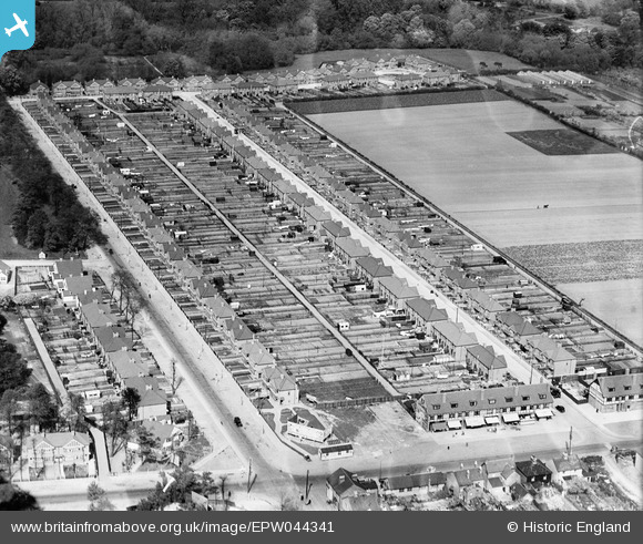
EPW044341 ENGLAND (1934). Hounslow Road, Sunningdale Avenue and environs, Hanworth, 1934
© Copyright OpenStreetMap contributors and licensed by the OpenStreetMap Foundation. 2025. Cartography is licensed as CC BY-SA.
Nearby Images (6)
Details
| Title | [EPW044341] Hounslow Road, Sunningdale Avenue and environs, Hanworth, 1934 |
| Reference | EPW044341 |
| Date | May-1934 |
| Link | |
| Place name | HANWORTH |
| Parish | |
| District | |
| Country | ENGLAND |
| Easting / Northing | 512225, 172647 |
| Longitude / Latitude | -0.38509657527345, 51.44119425375 |
| National Grid Reference | TQ122726 |
Pins
 waylou |
Monday 20th of July 2015 12:25:12 AM |


![[EPW044341] Hounslow Road, Sunningdale Avenue and environs, Hanworth, 1934](http://britainfromabove.org.uk/sites/all/libraries/aerofilms-images/public/100x100/EPW/044/EPW044341.jpg)
![[EPW044338] Sunningdale Avenue and environs, Hanworth, 1934](http://britainfromabove.org.uk/sites/all/libraries/aerofilms-images/public/100x100/EPW/044/EPW044338.jpg)
![[EPW044339] Sunningdale Avenue and environs, Hanworth, 1934](http://britainfromabove.org.uk/sites/all/libraries/aerofilms-images/public/100x100/EPW/044/EPW044339.jpg)
![[EPW044340] Market Parade, Hounslow Road and environs, Hanworth, 1934](http://britainfromabove.org.uk/sites/all/libraries/aerofilms-images/public/100x100/EPW/044/EPW044340.jpg)
![[EAW023688] The Trianco Boiler Works and the Rex Cinema, Hanworth, 1949](http://britainfromabove.org.uk/sites/all/libraries/aerofilms-images/public/100x100/EAW/023/EAW023688.jpg)
![[EPW028597] Hanworth Park Aerodrome (London Air Park) and environs, Hanworth Park, from the east, 1929](http://britainfromabove.org.uk/sites/all/libraries/aerofilms-images/public/100x100/EPW/028/EPW028597.jpg)