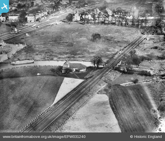
EPW031240 ENGLAND (1930). The Grand Union Canal, the Southern Railway Loop Line and the Great West Road, Brentford, 1930
© Copyright OpenStreetMap contributors and licensed by the OpenStreetMap Foundation. 2025. Cartography is licensed as CC BY-SA.
Nearby Images (31)
Details
| Title | [EPW031240] The Grand Union Canal, the Southern Railway Loop Line and the Great West Road, Brentford, 1930 |
| Reference | EPW031240 |
| Date | 6-February-1930 |
| Link | |
| Place name | BRENTFORD |
| Parish | |
| District | |
| Country | ENGLAND |
| Easting / Northing | 517098, 177695 |
| Longitude / Latitude | -0.31333432813011, 51.485582415303 |
| National Grid Reference | TQ171777 |
Pins
 Mozzy |
Sunday 28th of December 2014 10:41:32 PM | |
 D Figueiredo |
Thursday 20th of December 2012 12:07:59 PM | |
 D Figueiredo |
Thursday 20th of December 2012 12:07:34 PM |


![[EPW031240] The Grand Union Canal, the Southern Railway Loop Line and the Great West Road, Brentford, 1930](http://britainfromabove.org.uk/sites/all/libraries/aerofilms-images/public/100x100/EPW/031/EPW031240.jpg)
![[EPW031244] The Grand Union Canal, the Southern Railway Loop Line and the Great West Road, Brentford, 1930](http://britainfromabove.org.uk/sites/all/libraries/aerofilms-images/public/100x100/EPW/031/EPW031244.jpg)
![[EPW031241] The Grand Union Canal, the Southern Railway Loop Line and the Great West Road, Brentford, 1930](http://britainfromabove.org.uk/sites/all/libraries/aerofilms-images/public/100x100/EPW/031/EPW031241.jpg)
![[EPW031243] The Grand Union Canal, the Southern Railway Loop Line and the Great West Road, Brentford, 1930](http://britainfromabove.org.uk/sites/all/libraries/aerofilms-images/public/100x100/EPW/031/EPW031243.jpg)
![[EPW052234] The site of the Brentford Business Centre on Commerce Road, Brentford, 1936](http://britainfromabove.org.uk/sites/all/libraries/aerofilms-images/public/100x100/EPW/052/EPW052234.jpg)
![[EPW057074] The Sperry Gyroscope Company Ltd and environs, Brentford, 1938](http://britainfromabove.org.uk/sites/all/libraries/aerofilms-images/public/100x100/EPW/057/EPW057074.jpg)
![[EPW057077] The Sperry Gyroscope Company Ltd on the Great West Road, Brentford, 1938](http://britainfromabove.org.uk/sites/all/libraries/aerofilms-images/public/100x100/EPW/057/EPW057077.jpg)
![[EPW052233] The site of the Brentford Business Centre on Commerce Road, Brentford, 1936](http://britainfromabove.org.uk/sites/all/libraries/aerofilms-images/public/100x100/EPW/052/EPW052233.jpg)
![[EPW034930] The Sperry Gyroscope Manufactory, Jantzen Knitting Mills, the Great West Road and environs, Brentford, 1931](http://britainfromabove.org.uk/sites/all/libraries/aerofilms-images/public/100x100/EPW/034/EPW034930.jpg)
![[EPW057078] The Sperry Gyroscope Company Ltd and adjacent factories on the Great West Road, Brentford, 1938](http://britainfromabove.org.uk/sites/all/libraries/aerofilms-images/public/100x100/EPW/057/EPW057078.jpg)
![[EPW034931] The Sperry Gyroscope Manufactory and the Jantzen Knitting Mills on the Great West Road, Brentford, 1931](http://britainfromabove.org.uk/sites/all/libraries/aerofilms-images/public/100x100/EPW/034/EPW034931.jpg)
![[EPW057076] The Sperry Gyroscope Company Ltd and adjacent factories on the Great West Road, Brentford, 1938](http://britainfromabove.org.uk/sites/all/libraries/aerofilms-images/public/100x100/EPW/057/EPW057076.jpg)
![[EPW052239] The site of the Brentford Business Centre on Commerce Road, Brentford, 1936. This image was produced from a damaged negative.](http://britainfromabove.org.uk/sites/all/libraries/aerofilms-images/public/100x100/EPW/052/EPW052239.jpg)
![[EPW057075] The Sperry Gyroscope Company Ltd and adjacent factories on the Great West Road, Brentford, 1938](http://britainfromabove.org.uk/sites/all/libraries/aerofilms-images/public/100x100/EPW/057/EPW057075.jpg)
![[EPW052236] The site of the Brentford Business Centre on Commerce Road, Brentford, 1936. This image has been produced from a damaged negative.](http://britainfromabove.org.uk/sites/all/libraries/aerofilms-images/public/100x100/EPW/052/EPW052236.jpg)
![[EPW057073] The Sperry Gyroscope Company Ltd and adjacent factories on the Great West Road, Brentford, 1938](http://britainfromabove.org.uk/sites/all/libraries/aerofilms-images/public/100x100/EPW/057/EPW057073.jpg)
![[EPW052240] The site of the Brentford Business Centre on Commerce Road, Brentford, 1936. This image has been produced from a print.](http://britainfromabove.org.uk/sites/all/libraries/aerofilms-images/public/100x100/EPW/052/EPW052240.jpg)
![[EPW052235] The site of the Brentford Business Centre on Commerce Road, Brentford, 1936. This image has been produced from a damaged negative.](http://britainfromabove.org.uk/sites/all/libraries/aerofilms-images/public/100x100/EPW/052/EPW052235.jpg)
![[EPW052238] The site of the Brentford Business Centre on Commerce Road, Brentford, 1936](http://britainfromabove.org.uk/sites/all/libraries/aerofilms-images/public/100x100/EPW/052/EPW052238.jpg)
![[EPW035096] The Grand Union Canal and environs, Brentford End, 1931](http://britainfromabove.org.uk/sites/all/libraries/aerofilms-images/public/100x100/EPW/035/EPW035096.jpg)
![[EPW052237] The site of the Brentford Business Centre on Commerce Road, Brentford, 1936. This image has been produced from a damaged negative.](http://britainfromabove.org.uk/sites/all/libraries/aerofilms-images/public/100x100/EPW/052/EPW052237.jpg)
![[EPW031242] The Southern Railway Loop Line, the Great West Road and housing surrounding Somerset Road, Brentford, 1930](http://britainfromabove.org.uk/sites/all/libraries/aerofilms-images/public/100x100/EPW/031/EPW031242.jpg)
![[EPW049467] The Thompson and Norris Corrugated Cases Manufactory, Brentford, 1935](http://britainfromabove.org.uk/sites/all/libraries/aerofilms-images/public/100x100/EPW/049/EPW049467.jpg)
![[EPW049473] The Thompson and Norris Corrugated Cases Manufactory, Brentford, 1935](http://britainfromabove.org.uk/sites/all/libraries/aerofilms-images/public/100x100/EPW/049/EPW049473.jpg)
![[EPW049470] The Thompson and Norris Corrugated Cases Manufactory, Brentford, 1935](http://britainfromabove.org.uk/sites/all/libraries/aerofilms-images/public/100x100/EPW/049/EPW049470.jpg)
![[EPW049471] The Thompson and Norris Corrugated Cases Manufactory, Brentford, 1935](http://britainfromabove.org.uk/sites/all/libraries/aerofilms-images/public/100x100/EPW/049/EPW049471.jpg)
![[EPW049472] The Thompson and Norris Corrugated Cases Manufactory, Brentford, 1935](http://britainfromabove.org.uk/sites/all/libraries/aerofilms-images/public/100x100/EPW/049/EPW049472.jpg)
![[EPW031245] The junction between the Great West Road and Manor Road, Brentford, 1930](http://britainfromabove.org.uk/sites/all/libraries/aerofilms-images/public/100x100/EPW/031/EPW031245.jpg)
![[EPW049468] The Thompson and Norris Corrugated Cases Manufactory, Brentford, 1935](http://britainfromabove.org.uk/sites/all/libraries/aerofilms-images/public/100x100/EPW/049/EPW049468.jpg)
![[EPW049469] The Thompson and Norris Corrugated Cases Manufactory, Brentford, 1935](http://britainfromabove.org.uk/sites/all/libraries/aerofilms-images/public/100x100/EPW/049/EPW049469.jpg)
![[EPW025230] The Firestone Rubber Tyre Manufactory and the Great West Road, Brentford, from the north-east, 1928](http://britainfromabove.org.uk/sites/all/libraries/aerofilms-images/public/100x100/EPW/025/EPW025230.jpg)