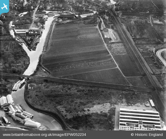
EPW052234 ENGLAND (1936). The site of the Brentford Business Centre on Commerce Road, Brentford, 1936
© Copyright OpenStreetMap contributors and licensed by the OpenStreetMap Foundation. 2025. Cartography is licensed as CC BY-SA.
Nearby Images (14)
Details
| Title | [EPW052234] The site of the Brentford Business Centre on Commerce Road, Brentford, 1936 |
| Reference | EPW052234 |
| Date | November-1936 |
| Link | |
| Place name | BRENTFORD |
| Parish | |
| District | |
| Country | ENGLAND |
| Easting / Northing | 517073, 177572 |
| Longitude / Latitude | -0.31373504851757, 51.484481990581 |
| National Grid Reference | TQ171776 |


![[EPW052234] The site of the Brentford Business Centre on Commerce Road, Brentford, 1936](http://britainfromabove.org.uk/sites/all/libraries/aerofilms-images/public/100x100/EPW/052/EPW052234.jpg)
![[EPW052240] The site of the Brentford Business Centre on Commerce Road, Brentford, 1936. This image has been produced from a print.](http://britainfromabove.org.uk/sites/all/libraries/aerofilms-images/public/100x100/EPW/052/EPW052240.jpg)
![[EPW031244] The Grand Union Canal, the Southern Railway Loop Line and the Great West Road, Brentford, 1930](http://britainfromabove.org.uk/sites/all/libraries/aerofilms-images/public/100x100/EPW/031/EPW031244.jpg)
![[EPW052236] The site of the Brentford Business Centre on Commerce Road, Brentford, 1936. This image has been produced from a damaged negative.](http://britainfromabove.org.uk/sites/all/libraries/aerofilms-images/public/100x100/EPW/052/EPW052236.jpg)
![[EPW052239] The site of the Brentford Business Centre on Commerce Road, Brentford, 1936. This image was produced from a damaged negative.](http://britainfromabove.org.uk/sites/all/libraries/aerofilms-images/public/100x100/EPW/052/EPW052239.jpg)
![[EPW031243] The Grand Union Canal, the Southern Railway Loop Line and the Great West Road, Brentford, 1930](http://britainfromabove.org.uk/sites/all/libraries/aerofilms-images/public/100x100/EPW/031/EPW031243.jpg)
![[EPW052235] The site of the Brentford Business Centre on Commerce Road, Brentford, 1936. This image has been produced from a damaged negative.](http://britainfromabove.org.uk/sites/all/libraries/aerofilms-images/public/100x100/EPW/052/EPW052235.jpg)
![[EPW035096] The Grand Union Canal and environs, Brentford End, 1931](http://britainfromabove.org.uk/sites/all/libraries/aerofilms-images/public/100x100/EPW/035/EPW035096.jpg)
![[EPW052237] The site of the Brentford Business Centre on Commerce Road, Brentford, 1936. This image has been produced from a damaged negative.](http://britainfromabove.org.uk/sites/all/libraries/aerofilms-images/public/100x100/EPW/052/EPW052237.jpg)
![[EPW052238] The site of the Brentford Business Centre on Commerce Road, Brentford, 1936](http://britainfromabove.org.uk/sites/all/libraries/aerofilms-images/public/100x100/EPW/052/EPW052238.jpg)
![[EPW052233] The site of the Brentford Business Centre on Commerce Road, Brentford, 1936](http://britainfromabove.org.uk/sites/all/libraries/aerofilms-images/public/100x100/EPW/052/EPW052233.jpg)
![[EPW031240] The Grand Union Canal, the Southern Railway Loop Line and the Great West Road, Brentford, 1930](http://britainfromabove.org.uk/sites/all/libraries/aerofilms-images/public/100x100/EPW/031/EPW031240.jpg)
![[EPW031241] The Grand Union Canal, the Southern Railway Loop Line and the Great West Road, Brentford, 1930](http://britainfromabove.org.uk/sites/all/libraries/aerofilms-images/public/100x100/EPW/031/EPW031241.jpg)
![[EPW025230] The Firestone Rubber Tyre Manufactory and the Great West Road, Brentford, from the north-east, 1928](http://britainfromabove.org.uk/sites/all/libraries/aerofilms-images/public/100x100/EPW/025/EPW025230.jpg)

