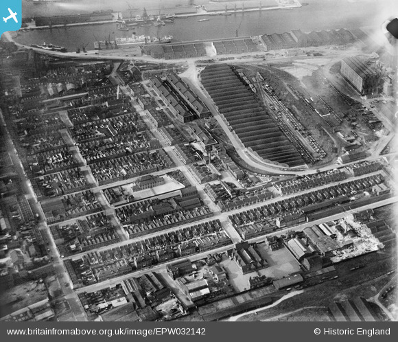
EPW032142 ENGLAND (1930). The Western Granaries and Grain Depot, Millwall, 1930
© Copyright OpenStreetMap contributors and licensed by the OpenStreetMap Foundation. 2025. Cartography is licensed as CC BY-SA.
Nearby Images (16)
Details
| Title | [EPW032142] The Western Granaries and Grain Depot, Millwall, 1930 |
| Reference | EPW032142 |
| Date | May-1930 |
| Link | |
| Place name | MILLWALL |
| Parish | |
| District | |
| Country | ENGLAND |
| Easting / Northing | 537359, 179540 |
| Longitude / Latitude | -0.02095254883359, 51.497605086109 |
| National Grid Reference | TQ374795 |
Pins
Be the first to add a comment to this image!
User Comment Contributions
Millwall Central School in middle of photo with large playground on Janet St side. Mentally Defective School is just to the left of it. The Tooke Arms is further to the left standing on the corner of Janet St and West Ferry Rd. The warehouse next to the pub is Roberts Warbler Steel Scockists |
 PeterJames |
Saturday 20th of October 2012 11:36:30 PM |


![[EPW032142] The Western Granaries and Grain Depot, Millwall, 1930](http://britainfromabove.org.uk/sites/all/libraries/aerofilms-images/public/100x100/EPW/032/EPW032142.jpg)
![[EPW032137] Aplha Road and environs, Millwall, 1930](http://britainfromabove.org.uk/sites/all/libraries/aerofilms-images/public/100x100/EPW/032/EPW032137.jpg)
![[EPW032139] Western Granaries, the Grain Depot and Millwall Inner Dock, Millwall, 1930](http://britainfromabove.org.uk/sites/all/libraries/aerofilms-images/public/100x100/EPW/032/EPW032139.jpg)
![[EPW032143] The Western Granaries and Grain Depot, Millwall, 1930](http://britainfromabove.org.uk/sites/all/libraries/aerofilms-images/public/100x100/EPW/032/EPW032143.jpg)
![[EPW032141] The Western Granaries and Grain Depot, Millwall, 1930](http://britainfromabove.org.uk/sites/all/libraries/aerofilms-images/public/100x100/EPW/032/EPW032141.jpg)
![[EPW044128] West India and Millwall Docks, Isle of Dogs, from the south-west, 1934](http://britainfromabove.org.uk/sites/all/libraries/aerofilms-images/public/100x100/EPW/044/EPW044128.jpg)
![[EPW032140] The Western Granaries and Grain Depot, Millwall, 1930](http://britainfromabove.org.uk/sites/all/libraries/aerofilms-images/public/100x100/EPW/032/EPW032140.jpg)
![[EPW032138] Western Granaries, Grain Depot and South Dock, Millwall, 1930](http://britainfromabove.org.uk/sites/all/libraries/aerofilms-images/public/100x100/EPW/032/EPW032138.jpg)
![[EPW032136] The Western Granaries and Grain Depot at Millwall Inner Dock, Millwall, 1930](http://britainfromabove.org.uk/sites/all/libraries/aerofilms-images/public/100x100/EPW/032/EPW032136.jpg)
![[EAW009114] Millwall, Isle of Dogs, 1947](http://britainfromabove.org.uk/sites/all/libraries/aerofilms-images/public/100x100/EAW/009/EAW009114.jpg)
![[EPW006141] Millwall, Isle of Dogs, 1921](http://britainfromabove.org.uk/sites/all/libraries/aerofilms-images/public/100x100/EPW/006/EPW006141.jpg)
![[EAW021721] A cityscape over Deptford and Millwall, Isle of Dogs, 1949. This image has been produced from a print.](http://britainfromabove.org.uk/sites/all/libraries/aerofilms-images/public/100x100/EAW/021/EAW021721.jpg)
![[EAW045810] West Ferry Road and environs, Millwall, 1952. This image was marked by Aerofilms Ltd for photo editing.](http://britainfromabove.org.uk/sites/all/libraries/aerofilms-images/public/100x100/EAW/045/EAW045810.jpg)
![[EPW044135] South Dock, Millwall Inner Dock and environs, Isle of Dogs, 1934](http://britainfromabove.org.uk/sites/all/libraries/aerofilms-images/public/100x100/EPW/044/EPW044135.jpg)
![[EAW112904] West India and Millwall Docks, London, 1963](http://britainfromabove.org.uk/sites/all/libraries/aerofilms-images/public/100x100/EAW/112/EAW112904.jpg)
![[EAW045808] Strafford Street and wharfage on the River Thames behind West Ferry Road, Millwall, 1952. This image was marked by Aerofilms Ltd for photo editing.](http://britainfromabove.org.uk/sites/all/libraries/aerofilms-images/public/100x100/EAW/045/EAW045808.jpg)