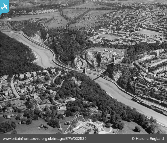
EPW032539 ENGLAND (1930). The Clifton Suspension Bridge and Observatory Hill, Long Ashton, 1930
© Copyright OpenStreetMap contributors and licensed by the OpenStreetMap Foundation. 2025. Cartography is licensed as CC BY-SA.
Nearby Images (17)
Details
| Title | [EPW032539] The Clifton Suspension Bridge and Observatory Hill, Long Ashton, 1930 |
| Reference | EPW032539 |
| Date | June-1930 |
| Link | |
| Place name | LONG ASHTON |
| Parish | LONG ASHTON |
| District | |
| Country | ENGLAND |
| Easting / Northing | 356377, 173018 |
| Longitude / Latitude | -2.6278889672394, 51.453972027722 |
| National Grid Reference | ST564730 |
Pins
 MrNCWilson |
Monday 18th of November 2013 07:34:17 PM |


![[EPW032539] The Clifton Suspension Bridge and Observatory Hill, Long Ashton, 1930](http://britainfromabove.org.uk/sites/all/libraries/aerofilms-images/public/100x100/EPW/032/EPW032539.jpg)
![[EPW022272] The Clifton Suspension Bridge, Clifton, 1928](http://britainfromabove.org.uk/sites/all/libraries/aerofilms-images/public/100x100/EPW/022/EPW022272.jpg)
![[EAW050559] The Clifton Suspension Bridge, Clifton, 1953](http://britainfromabove.org.uk/sites/all/libraries/aerofilms-images/public/100x100/EAW/050/EAW050559.jpg)
![[EAW050558] The Clifton Suspension Bridge, Clifton, 1953](http://britainfromabove.org.uk/sites/all/libraries/aerofilms-images/public/100x100/EAW/050/EAW050558.jpg)
![[EAW002263] The Clifton Suspension Bridge, Long Ashton, 1946](http://britainfromabove.org.uk/sites/all/libraries/aerofilms-images/public/100x100/EAW/002/EAW002263.jpg)
![[EAW016132] The Clifton Suspension Bridge, Clifton, from the south-east, 1948. This image has been produced from a damaged negative.](http://britainfromabove.org.uk/sites/all/libraries/aerofilms-images/public/100x100/EAW/016/EAW016132.jpg)
![[EAW033325] Clifton Suspension Bridge, Observatory Hill and the city, Clifton, from the west, 1950](http://britainfromabove.org.uk/sites/all/libraries/aerofilms-images/public/100x100/EAW/033/EAW033325.jpg)
![[EPR000063] The Clifton Suspension Bridge, Clifton, 1934](http://britainfromabove.org.uk/sites/all/libraries/aerofilms-images/public/100x100/EPR/000/EPR000063.jpg)
![[EAW050560] The Clifton Suspension Bridge, Clifton, 1953](http://britainfromabove.org.uk/sites/all/libraries/aerofilms-images/public/100x100/EAW/050/EAW050560.jpg)
![[EPW001274] The Clifton Suspension Bridge, Bristol, 1920](http://britainfromabove.org.uk/sites/all/libraries/aerofilms-images/public/100x100/EPW/001/EPW001274.jpg)
![[EPW022273] The Clifton Suspension Bridge, Clifton, from the south-east, 1928](http://britainfromabove.org.uk/sites/all/libraries/aerofilms-images/public/100x100/EPW/022/EPW022273.jpg)
![[EPW037150] The Clifton Suspension Bridge, Observatory Hill and environs, Clifton, 1931](http://britainfromabove.org.uk/sites/all/libraries/aerofilms-images/public/100x100/EPW/037/EPW037150.jpg)
![[EAW033323] Clifton Suspension Bridge and Observatory Hill, Clifton, from the south-west, 1950](http://britainfromabove.org.uk/sites/all/libraries/aerofilms-images/public/100x100/EAW/033/EAW033323.jpg)
![[EPW041480] The Clifton Suspension Bridge, Clifton Down promontory fort and environs, Clifton, 1933](http://britainfromabove.org.uk/sites/all/libraries/aerofilms-images/public/100x100/EPW/041/EPW041480.jpg)
![[EAW015138] The Clifton Suspension Bridge and Observatory Hill, Clifton, 1948](http://britainfromabove.org.uk/sites/all/libraries/aerofilms-images/public/100x100/EAW/015/EAW015138.jpg)
![[EPW012024] Clifton Suspension Bridge and the Observatory, Clifton, 1924. This image has been produced from a print.](http://britainfromabove.org.uk/sites/all/libraries/aerofilms-images/public/100x100/EPW/012/EPW012024.jpg)
![[EAW033327] Clifton Suspension Bridge, Observatory Hill and the city, Clifton, 1950](http://britainfromabove.org.uk/sites/all/libraries/aerofilms-images/public/100x100/EAW/033/EAW033327.jpg)