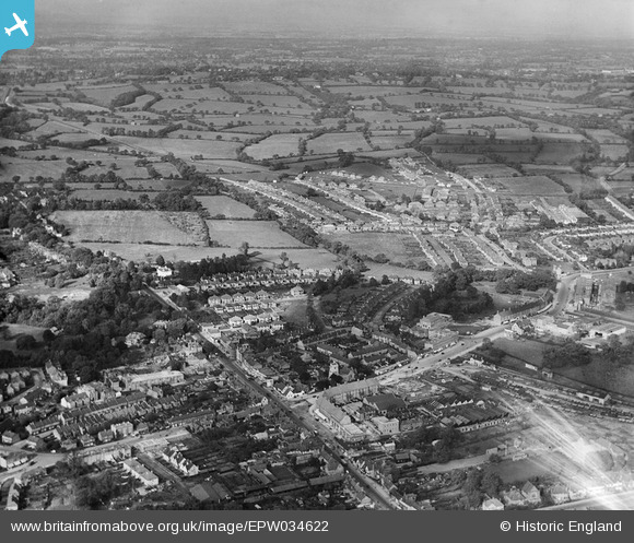
EPW034622 ENGLAND (1930). Housing development to the north of the old village, Edgware, from the south, 1930
© Copyright OpenStreetMap contributors and licensed by the OpenStreetMap Foundation. 2025. Cartography is licensed as CC BY-SA.
Nearby Images (18)
Details
| Title | [EPW034622] Housing development to the north of the old village, Edgware, from the south, 1930 |
| Reference | EPW034622 |
| Date | 16-October-1930 |
| Link | |
| Place name | EDGWARE |
| Parish | |
| District | |
| Country | ENGLAND |
| Easting / Northing | 519221, 191768 |
| Longitude / Latitude | -0.27799940849501, 51.611632214002 |
| National Grid Reference | TQ192918 |


![[EPW034622] Housing development to the north of the old village, Edgware, from the south, 1930](http://britainfromabove.org.uk/sites/all/libraries/aerofilms-images/public/100x100/EPW/034/EPW034622.jpg)
![[EPW034621] Housing development to the north of the old village, Edgware, from the south, 1930](http://britainfromabove.org.uk/sites/all/libraries/aerofilms-images/public/100x100/EPW/034/EPW034621.jpg)
![[EAW020692] Central Edgware and Hendon, Edgware, from the south-west, 1948](http://britainfromabove.org.uk/sites/all/libraries/aerofilms-images/public/100x100/EAW/020/EAW020692.jpg)
![[EPW015987] The High Street, Edgware, 1926](http://britainfromabove.org.uk/sites/all/libraries/aerofilms-images/public/100x100/EPW/015/EPW015987.jpg)
![[EPW016512] The railway station and environs, Edgware, 1926](http://britainfromabove.org.uk/sites/all/libraries/aerofilms-images/public/100x100/EPW/016/EPW016512.jpg)
![[EPW049509] Dorset Drive, Cavendish Drive and environs, Canons Park, 1935](http://britainfromabove.org.uk/sites/all/libraries/aerofilms-images/public/100x100/EPW/049/EPW049509.jpg)
![[EPW034612] Housing development around the railway stations, Edgware, from the west, 1930](http://britainfromabove.org.uk/sites/all/libraries/aerofilms-images/public/100x100/EPW/034/EPW034612.jpg)
![[EAW027667] A Hunting Aerosurveys DH.89A Rapide (G-AEAL) in flight over the Broadfields Avenue area, Edgware, from the south-west, 1949](http://britainfromabove.org.uk/sites/all/libraries/aerofilms-images/public/100x100/EAW/027/EAW027667.jpg)
![[EAW020693] Edgware and the view towards Borehamwood, Edgware, from the south, 1948](http://britainfromabove.org.uk/sites/all/libraries/aerofilms-images/public/100x100/EAW/020/EAW020693.jpg)
![[EPW005277] Wright and Sons Tool Works at Thorn Bank, Edgware, 1921](http://britainfromabove.org.uk/sites/all/libraries/aerofilms-images/public/100x100/EPW/005/EPW005277.jpg)
![[EPW016516] The underground station, bus depot and environs, Edgware, 1926](http://britainfromabove.org.uk/sites/all/libraries/aerofilms-images/public/100x100/EPW/016/EPW016516.jpg)
![[EPW015982] Edgware Railway Station, Edgware, 1926. This image has been produced from a copy-negative.](http://britainfromabove.org.uk/sites/all/libraries/aerofilms-images/public/100x100/EPW/015/EPW015982.jpg)
![[EPW009603] Station Road and environs, Edgware, 1923](http://britainfromabove.org.uk/sites/all/libraries/aerofilms-images/public/100x100/EPW/009/EPW009603.jpg)
![[EPW005281] Wright and Sons Tool Works at Thorn Bank, Edgware, 1921](http://britainfromabove.org.uk/sites/all/libraries/aerofilms-images/public/100x100/EPW/005/EPW005281.jpg)
![[EAW048861] Edgware Tube Station and the surrounding residential area, Edgware, 1953](http://britainfromabove.org.uk/sites/all/libraries/aerofilms-images/public/100x100/EAW/048/EAW048861.jpg)
![[EPW034623] Housing development to the north of the old village, Edgware, from the south-west, 1930](http://britainfromabove.org.uk/sites/all/libraries/aerofilms-images/public/100x100/EPW/034/EPW034623.jpg)
![[EPW015983] Chandos Crescent and Montgomery Road, Canons Park, 1926. This image has been produced from a print.](http://britainfromabove.org.uk/sites/all/libraries/aerofilms-images/public/100x100/EPW/015/EPW015983.jpg)
![[EPW009376] Construction of underground station, Edgware, 1923](http://britainfromabove.org.uk/sites/all/libraries/aerofilms-images/public/100x100/EPW/009/EPW009376.jpg)

