
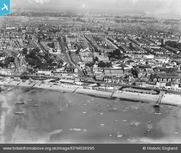
EPW036995 ENGLAND (1931). The Kursaal, Southchurch Avenue and environs, Southend-on-Sea, from the south-west, 1931
© Copyright OpenStreetMap contributors and licensed by the OpenStreetMap Foundation. 2025. Cartography is licensed as CC BY-SA.
Nearby Images (48)
EPW036995

EAW053086

EPW058226

EAW002219

EAW024660

EPW036730

EPW058222

EPW058224

EPW000444

EPW000443

EPW037003

EPW037016

EPW062745

EPW024890

EPW036726

EPW024887

EPW040987

EAW002192

EPW036612

EPW037004

EPW000552

EPW032920

EAW002206

EPW058500

EPW024869

EAW024659

EPW036615

EPW062743

EPW032919

EPW036613

EPW036616

EPW036978

EPW039865

EPW040961

EPW016549

EPW010871

EPW039864

EPW062744

EPW036982

EPW039862

EPW054671

EPW062746

EPW062747

EPW036617

EPW036979

EPW039863

EPW039866

EAW002189

Details
| Title | [EPW036995] The Kursaal, Southchurch Avenue and environs, Southend-on-Sea, from the south-west, 1931 |
| Reference | EPW036995 |
| Date | October-1931 |
| Link | |
| Place name | SOUTHEND-ON-SEA |
| Parish | |
| District | |
| Country | ENGLAND |
| Easting / Northing | 589034, 184959 |
| Longitude / Latitude | 0.72569723747066, 51.531364464453 |
| National Grid Reference | TQ890850 |
Pins
 bargee1937 |
Thursday 18th of June 2015 11:03:54 PM | |
bargee1937 |
Thursday 18th of June 2015 11:00:46 PM |