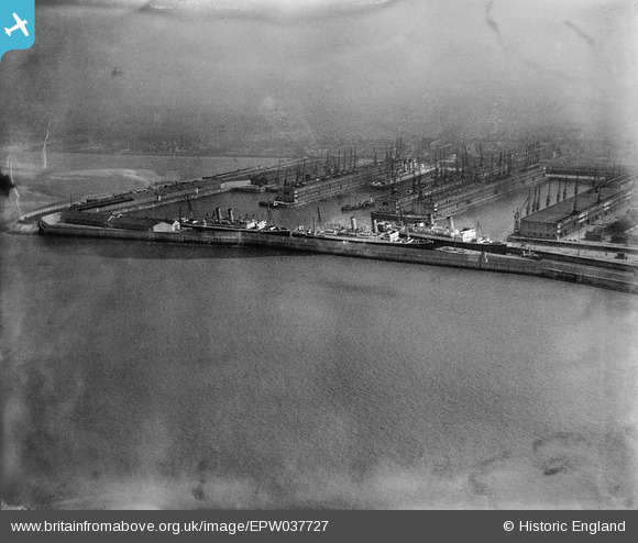
EPW037727 ENGLAND (1932). Gladstone Dock, Bootle, 1932
© Copyright OpenStreetMap contributors and licensed by the OpenStreetMap Foundation. 2025. Cartography is licensed as CC BY-SA.
Nearby Images (14)
Details
| Title | [EPW037727] Gladstone Dock, Bootle, 1932 |
| Reference | EPW037727 |
| Date | May-1932 |
| Link | |
| Place name | BOOTLE |
| Parish | |
| District | |
| Country | ENGLAND |
| Easting / Northing | 332295, 395712 |
| Longitude / Latitude | -3.0196909863151, 53.453553792448 |
| National Grid Reference | SJ323957 |
Pins
Be the first to add a comment to this image!


![[EPW037727] Gladstone Dock, Bootle, 1932](http://britainfromabove.org.uk/sites/all/libraries/aerofilms-images/public/100x100/EPW/037/EPW037727.jpg)
![[EAW001711] Gladstone Docks and environs, Bootle, from the west, 1946](http://britainfromabove.org.uk/sites/all/libraries/aerofilms-images/public/100x100/EAW/001/EAW001711.jpg)
![[EAW004630] Gladstone Dock to Canada Dock, Bootle, from the north-west, 1947](http://britainfromabove.org.uk/sites/all/libraries/aerofilms-images/public/100x100/EAW/004/EAW004630.jpg)
![[EAW048043] Gladstone Dock and environs, Bootle, from the south-west, 1952](http://britainfromabove.org.uk/sites/all/libraries/aerofilms-images/public/100x100/EAW/048/EAW048043.jpg)
![[EAW004632] Gladstone Dock, Bootle, from the north-west, 1947](http://britainfromabove.org.uk/sites/all/libraries/aerofilms-images/public/100x100/EAW/004/EAW004632.jpg)
![[EAW048047] Gladstone Dock, Bootle, from the south-west, 1952](http://britainfromabove.org.uk/sites/all/libraries/aerofilms-images/public/100x100/EAW/048/EAW048047.jpg)
![[EAW004633] Gladstone Dock, Bootle, from the west, 1947](http://britainfromabove.org.uk/sites/all/libraries/aerofilms-images/public/100x100/EAW/004/EAW004633.jpg)
![[EAW004631] Gladstone Dock to Langton Dock, Bootle, from the west, 1947](http://britainfromabove.org.uk/sites/all/libraries/aerofilms-images/public/100x100/EAW/004/EAW004631.jpg)
![[EPW018872] Gladstone Dock, Bootle, 1927. This image has been produced from a print.](http://britainfromabove.org.uk/sites/all/libraries/aerofilms-images/public/100x100/EPW/018/EPW018872.jpg)
![[EAW048044] Gladstone Dock, Bootle, from the west, 1952](http://britainfromabove.org.uk/sites/all/libraries/aerofilms-images/public/100x100/EAW/048/EAW048044.jpg)
![[EAW001710] Gladstone Docks and environs, Bootle, from the west, 1946](http://britainfromabove.org.uk/sites/all/libraries/aerofilms-images/public/100x100/EAW/001/EAW001710.jpg)
![[EPW023555] Gladstone Docks, Bootle, 1928](http://britainfromabove.org.uk/sites/all/libraries/aerofilms-images/public/100x100/EPW/023/EPW023555.jpg)
![[EAW051426] Gladstone Dock, Bootle, 1953](http://britainfromabove.org.uk/sites/all/libraries/aerofilms-images/public/100x100/EAW/051/EAW051426.jpg)
![[EAW042532] Gladstone Docks, Bootle, from the south, 1952](http://britainfromabove.org.uk/sites/all/libraries/aerofilms-images/public/100x100/EAW/042/EAW042532.jpg)