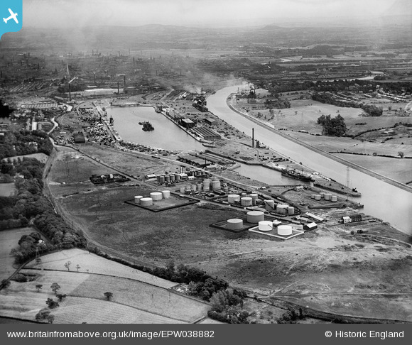
EPW038882 ENGLAND (1932). Preston Docks and the city, Preston, from the north-west, 1932
© Copyright OpenStreetMap contributors and licensed by the OpenStreetMap Foundation. 2025. Cartography is licensed as CC BY-SA.
Nearby Images (15)
Details
| Title | [EPW038882] Preston Docks and the city, Preston, from the north-west, 1932 |
| Reference | EPW038882 |
| Date | July-1932 |
| Link | |
| Place name | PRESTON |
| Parish | |
| District | |
| Country | ENGLAND |
| Easting / Northing | 350306, 429584 |
| Longitude / Latitude | -2.7538641364543, 53.760020157028 |
| National Grid Reference | SD503296 |
Pins
 wolrab64 |
Thursday 11th of March 2021 08:52:38 PM |


![[EPW038882] Preston Docks and the city, Preston, from the north-west, 1932](http://britainfromabove.org.uk/sites/all/libraries/aerofilms-images/public/100x100/EPW/038/EPW038882.jpg)
![[EPW034871] Watsons ROP oil storage depot at the entrance to Preston Docks, Preston, 1931](http://britainfromabove.org.uk/sites/all/libraries/aerofilms-images/public/100x100/EPW/034/EPW034871.jpg)
![[EPW034870] Watsons ROP oil storage depot at the entrance to Preston Docks, Preston, 1931](http://britainfromabove.org.uk/sites/all/libraries/aerofilms-images/public/100x100/EPW/034/EPW034870.jpg)
![[EPW034869] Watsons ROP oil storage depot at the entrance to Preston Docks, Preston, 1931](http://britainfromabove.org.uk/sites/all/libraries/aerofilms-images/public/100x100/EPW/034/EPW034869.jpg)
![[EPW034866] Watsons ROP oil storage depot at the entrance to Preston Docks, Preston, 1931](http://britainfromabove.org.uk/sites/all/libraries/aerofilms-images/public/100x100/EPW/034/EPW034866.jpg)
![[EPW034863] Watsons ROP oil storage depot at the entrance to Preston Docks, Preston, 1931](http://britainfromabove.org.uk/sites/all/libraries/aerofilms-images/public/100x100/EPW/034/EPW034863.jpg)
![[EPW038880] Albert Edward Dock, the River Ribble and the city, Preston, from the west, 1932](http://britainfromabove.org.uk/sites/all/libraries/aerofilms-images/public/100x100/EPW/038/EPW038880.jpg)
![[EPW034865] Watsons ROP oil storage depot at the entrance to Preston Docks, Preston, 1931](http://britainfromabove.org.uk/sites/all/libraries/aerofilms-images/public/100x100/EPW/034/EPW034865.jpg)
![[EPW034864] Watsons ROP oil storage depot at the entrance to Preston Docks, Preston, 1931](http://britainfromabove.org.uk/sites/all/libraries/aerofilms-images/public/100x100/EPW/034/EPW034864.jpg)
![[EPW034868] Watsons ROP oil storage depot at the entrance to Preston Docks, Preston, 1931](http://britainfromabove.org.uk/sites/all/libraries/aerofilms-images/public/100x100/EPW/034/EPW034868.jpg)
![[EPW034867] Watsons ROP oil storage depot at the entrance to Preston Docks, Preston, 1931](http://britainfromabove.org.uk/sites/all/libraries/aerofilms-images/public/100x100/EPW/034/EPW034867.jpg)
![[EPW038853] The Leyland Motor Works,The Dock Basin, Albert Edward Dock and River Ribble, Preston, from the west, 1932. This image has been produced from a damaged negative.](http://britainfromabove.org.uk/sites/all/libraries/aerofilms-images/public/100x100/EPW/038/EPW038853.jpg)
![[EAW050355] Shell-Mex and BP Ltd oil storage depot on Chain Caul Road, Preston, 1953](http://britainfromabove.org.uk/sites/all/libraries/aerofilms-images/public/100x100/EAW/050/EAW050355.jpg)
![[EAW050356] Shell-Mex and BP Ltd oil storage depot on Chain Caul Road, Preston, 1953. This image was marked by Aerofilms Ltd for photo editing.](http://britainfromabove.org.uk/sites/all/libraries/aerofilms-images/public/100x100/EAW/050/EAW050356.jpg)
![[EPW038881] Oil storage depot at Preston Docks, Preston, 1932](http://britainfromabove.org.uk/sites/all/libraries/aerofilms-images/public/100x100/EPW/038/EPW038881.jpg)