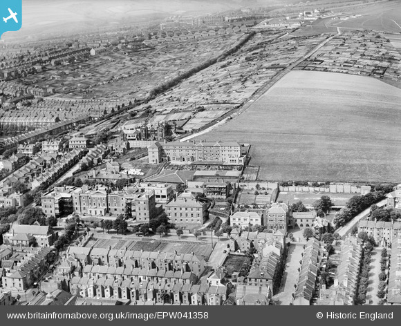
EPW041358 ENGLAND (1933). The Royal Sussex County Hospital, Brighton, 1933
© Copyright OpenStreetMap contributors and licensed by the OpenStreetMap Foundation. 2025. Cartography is licensed as CC BY-SA.
Nearby Images (7)
Details
| Title | [EPW041358] The Royal Sussex County Hospital, Brighton, 1933 |
| Reference | EPW041358 |
| Date | May-1933 |
| Link | |
| Place name | BRIGHTON |
| Parish | |
| District | |
| Country | ENGLAND |
| Easting / Northing | 532719, 103982 |
| Longitude / Latitude | -0.11564512565059, 50.819591499257 |
| National Grid Reference | TQ327040 |
Pins
 Paul Wendon |
Wednesday 17th of February 2021 01:08:21 PM | |
 Paul Wendon |
Wednesday 17th of February 2021 11:57:54 AM | |
 Paul Wendon |
Wednesday 17th of February 2021 11:56:29 AM | |
 Paul Wendon |
Wednesday 17th of February 2021 11:54:28 AM | |
 Paul Wendon |
Wednesday 17th of February 2021 11:54:14 AM | |
 Brightonboy |
Saturday 27th of June 2020 09:31:16 PM | |
 Alan McFaden |
Monday 29th of July 2013 05:29:26 PM |


![[EPW041358] The Royal Sussex County Hospital, Brighton, 1933](http://britainfromabove.org.uk/sites/all/libraries/aerofilms-images/public/100x100/EPW/041/EPW041358.jpg)
![[EPW041359] The Royal Sussex County Hospital, Brighton, 1933](http://britainfromabove.org.uk/sites/all/libraries/aerofilms-images/public/100x100/EPW/041/EPW041359.jpg)
![[EPW041355] The Royal Sussex County Hospital, Brighton, 1933](http://britainfromabove.org.uk/sites/all/libraries/aerofilms-images/public/100x100/EPW/041/EPW041355.jpg)
![[EPW041356] The Royal Sussex County Hospital, Brighton, 1933](http://britainfromabove.org.uk/sites/all/libraries/aerofilms-images/public/100x100/EPW/041/EPW041356.jpg)
![[EPW041357] The Royal Sussex County Hospital, Brighton, 1933](http://britainfromabove.org.uk/sites/all/libraries/aerofilms-images/public/100x100/EPW/041/EPW041357.jpg)
![[EPW041354] The Royal Sussex County Hospital, Brighton, 1933](http://britainfromabove.org.uk/sites/all/libraries/aerofilms-images/public/100x100/EPW/041/EPW041354.jpg)
![[EPW041360] The Royal Sussex County Hospital and Whitehawk Hill, Brighton, from the south-west, 1933](http://britainfromabove.org.uk/sites/all/libraries/aerofilms-images/public/100x100/EPW/041/EPW041360.jpg)
