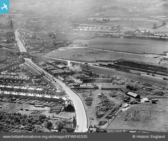
EPW041535 ENGLAND (1933). Oates Ltd Timber Merchants and environs, Worksop, from the north, 1933
© Copyright OpenStreetMap contributors and licensed by the OpenStreetMap Foundation. 2024. Cartography is licensed as CC BY-SA.
Nearby Images (22)
Details
| Title | [EPW041535] Oates Ltd Timber Merchants and environs, Worksop, from the north, 1933 |
| Reference | EPW041535 |
| Date | June-1933 |
| Link | |
| Place name | WORKSOP |
| Parish | |
| District | |
| Country | ENGLAND |
| Easting / Northing | 457995, 380121 |
| Longitude / Latitude | -1.1293928847893, 53.31457112188 |
| National Grid Reference | SK580801 |
Pins
 PrioriesHistoricalSociety |
Tuesday 15th of October 2013 10:34:13 AM | |
 PrioriesHistoricalSociety |
Tuesday 15th of October 2013 10:33:41 AM |


![[EPW041535] Oates Ltd Timber Merchants and environs, Worksop, from the north, 1933](http://britainfromabove.org.uk/sites/all/libraries/aerofilms-images/public/100x100/EPW/041/EPW041535.jpg)
![[EPW041536] Oates Ltd Timber Merchants and Gateford Road, Worksop, 1933](http://britainfromabove.org.uk/sites/all/libraries/aerofilms-images/public/100x100/EPW/041/EPW041536.jpg)
![[EAW027204] Oates Ltd Timber Merchants, Worksop, 1949. This image has been produced from a print marked by Aerofilms Ltd for photo editing.](http://britainfromabove.org.uk/sites/all/libraries/aerofilms-images/public/100x100/EAW/027/EAW027204.jpg)
![[EAW027202] Oates Ltd Timber Merchants, Worksop, 1949. This image was marked by Aerofilms Ltd for photo editing.](http://britainfromabove.org.uk/sites/all/libraries/aerofilms-images/public/100x100/EAW/027/EAW027202.jpg)
![[EPW041537] Oates Ltd Timber Merchants and Gateford Road, Worksop, 1933](http://britainfromabove.org.uk/sites/all/libraries/aerofilms-images/public/100x100/EPW/041/EPW041537.jpg)
![[EPW041538] Oates Ltd Timber Merchants and Gateford Road, Worksop, 1933](http://britainfromabove.org.uk/sites/all/libraries/aerofilms-images/public/100x100/EPW/041/EPW041538.jpg)
![[EPW041539] Oates Ltd Timber Merchants and Gateford Road, Worksop, 1933](http://britainfromabove.org.uk/sites/all/libraries/aerofilms-images/public/100x100/EPW/041/EPW041539.jpg)
![[EPW041534] Oates Ltd Timber Merchants, Worksop, 1933](http://britainfromabove.org.uk/sites/all/libraries/aerofilms-images/public/100x100/EPW/041/EPW041534.jpg)
![[EAW027200] Oates Ltd Timber Merchants, Worksop, 1949](http://britainfromabove.org.uk/sites/all/libraries/aerofilms-images/public/100x100/EAW/027/EAW027200.jpg)
![[EAW027203] Oates Ltd Timber Merchants, Worksop, 1949. This image was marked by Aerofilms Ltd for photo editing.](http://britainfromabove.org.uk/sites/all/libraries/aerofilms-images/public/100x100/EAW/027/EAW027203.jpg)
![[EPW041533] Oates Ltd Timber Merchants, Worksop, 1933](http://britainfromabove.org.uk/sites/all/libraries/aerofilms-images/public/100x100/EPW/041/EPW041533.jpg)
![[EAW027198] Oates Ltd Timber Merchants and the residential area surrounding James Street, Worksop, from the east, 1949. This image was marked by Aerofilms Ltd for photo editing.](http://britainfromabove.org.uk/sites/all/libraries/aerofilms-images/public/100x100/EAW/027/EAW027198.jpg)
![[EAW027196] Oates Ltd Timber Merchants and the surrounding area, Worksop, from the south-west, 1949. This image was marked by Aerofilms Ltd for photo editing.](http://britainfromabove.org.uk/sites/all/libraries/aerofilms-images/public/100x100/EAW/027/EAW027196.jpg)
![[EAW027201] Oates Ltd Timber Merchants, Worksop, from the south-east, 1949](http://britainfromabove.org.uk/sites/all/libraries/aerofilms-images/public/100x100/EAW/027/EAW027201.jpg)
![[EAW027197] Oates Ltd Timber Merchants and the residential area surrounding James Street, Worksop, from the east, 1949. This image was marked by Aerofilms Ltd for photo editing.](http://britainfromabove.org.uk/sites/all/libraries/aerofilms-images/public/100x100/EAW/027/EAW027197.jpg)
![[EAW043716] Batchelors Peas Ltd Works, Worksop, 1952. This image was marked by Aerofilms Ltd for photo editing.](http://britainfromabove.org.uk/sites/all/libraries/aerofilms-images/public/100x100/EAW/043/EAW043716.jpg)
![[EAW043719] Batchelors Peas Ltd Works, Worksop, 1952. This image was marked by Aerofilms Ltd for photo editing.](http://britainfromabove.org.uk/sites/all/libraries/aerofilms-images/public/100x100/EAW/043/EAW043719.jpg)
![[EAW043721] Batchelors Peas Ltd Works, Worksop, 1952. This image was marked by Aerofilms Ltd for photo editing.](http://britainfromabove.org.uk/sites/all/libraries/aerofilms-images/public/100x100/EAW/043/EAW043721.jpg)
![[EAW043720] Batchelors Peas Ltd Works, Worksop, 1952. This image was marked by Aerofilms Ltd for photo editing.](http://britainfromabove.org.uk/sites/all/libraries/aerofilms-images/public/100x100/EAW/043/EAW043720.jpg)
![[EAW027199] Oates Ltd Timber Merchants and the surrounding area, Worksop, from the south-west, 1949. This image was marked by Aerofilms Ltd for photo editing.](http://britainfromabove.org.uk/sites/all/libraries/aerofilms-images/public/100x100/EAW/027/EAW027199.jpg)
![[EAW043717] Batchelors Peas Ltd Works, Worksop, 1952. This image was marked by Aerofilms Ltd for photo editing.](http://britainfromabove.org.uk/sites/all/libraries/aerofilms-images/public/100x100/EAW/043/EAW043717.jpg)
![[EAW043715] Batchelors Peas Ltd Works, Worksop, 1952. This image was marked by Aerofilms Ltd for photo editing.](http://britainfromabove.org.uk/sites/all/libraries/aerofilms-images/public/100x100/EAW/043/EAW043715.jpg)