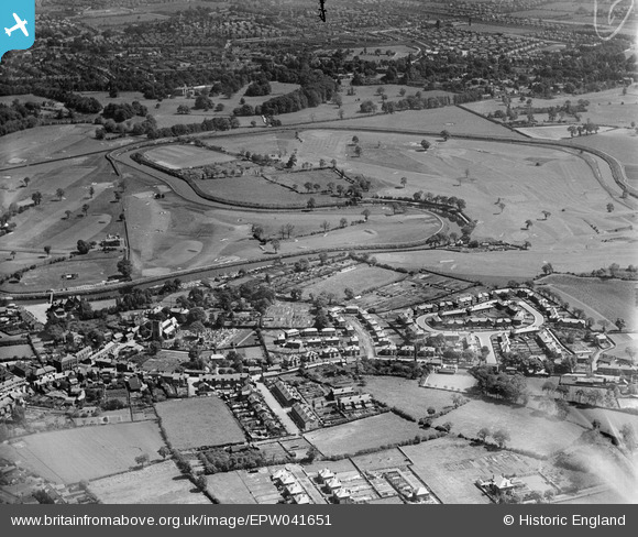
EPW041651 ENGLAND (1933). Housing off Royle Green Road, Bucklow Drive and the River Mersey, Northenden, 1933
© Copyright OpenStreetMap contributors and licensed by the OpenStreetMap Foundation. 2025. Cartography is licensed as CC BY-SA.
Details
| Title | [EPW041651] Housing off Royle Green Road, Bucklow Drive and the River Mersey, Northenden, 1933 |
| Reference | EPW041651 |
| Date | June-1933 |
| Link | |
| Place name | NORTHENDEN |
| Parish | |
| District | |
| Country | ENGLAND |
| Easting / Northing | 383570, 390120 |
| Longitude / Latitude | -2.2471772355968, 53.407379582365 |
| National Grid Reference | SJ836901 |
Pins
 H |
Wednesday 24th of April 2024 05:34:45 AM | |
 H |
Wednesday 24th of April 2024 05:26:43 AM | |
 H |
Wednesday 24th of April 2024 05:22:46 AM | |
 H |
Saturday 30th of September 2023 03:12:48 AM | |
 MisterB |
Friday 25th of October 2019 07:10:53 PM | |
 John Ellis |
Wednesday 26th of November 2014 05:02:03 PM | |
 John Ellis |
Wednesday 26th of November 2014 04:46:05 PM | |
 John Ellis |
Tuesday 25th of November 2014 03:03:56 PM | |
 John Ellis |
Tuesday 25th of November 2014 03:01:34 PM | |
 John Ellis |
Tuesday 25th of November 2014 03:00:22 PM | |
 John Ellis |
Tuesday 25th of November 2014 02:57:33 PM | |
 John Ellis |
Tuesday 25th of November 2014 02:56:16 PM | |
 John Ellis |
Tuesday 25th of November 2014 02:55:38 PM | |
 John Ellis |
Tuesday 25th of November 2014 02:54:07 PM | |
 John Ellis |
Tuesday 25th of November 2014 02:53:05 PM | |
 John Ellis |
Tuesday 25th of November 2014 02:50:51 PM | |
 John Ellis |
Tuesday 25th of November 2014 02:47:58 PM | |
 John Ellis |
Tuesday 25th of November 2014 02:47:30 PM | |
 brian chadwick |
Tuesday 29th of July 2014 05:42:59 PM | |
 Cancan |
Sunday 20th of July 2014 12:11:44 PM | |
 Cancan |
Sunday 20th of July 2014 11:42:15 AM | |
 Cancan |
Sunday 20th of July 2014 11:41:23 AM | |
 Cancan |
Sunday 20th of July 2014 11:39:25 AM | |
 Cancan |
Sunday 20th of July 2014 11:38:02 AM | |
 Cancan |
Sunday 20th of July 2014 11:34:07 AM | |
... for Withington Golf Club. |
 John Ellis |
Tuesday 25th of November 2014 02:58:55 PM |
 Cancan |
Sunday 20th of July 2014 11:14:50 AM | |
 Cancan |
Sunday 20th of July 2014 11:13:36 AM | |
 Cancan |
Sunday 20th of July 2014 11:08:32 AM | |
 Cancan |
Sunday 20th of July 2014 11:02:55 AM | |
 Cancan |
Sunday 20th of July 2014 11:00:39 AM | |
 Cancan |
Sunday 20th of July 2014 10:57:02 AM | |
 Cancan |
Sunday 20th of July 2014 10:54:48 AM | |
 Cancan |
Sunday 20th of July 2014 10:53:04 AM | |
It was Princess Road - the name was changed, from memory, in the mid-1950s as part of a council to eradicate replications of the same road names across Manchester. A few other streets in Northenden, and one in Baguley too, had their names similarly changed at the same time. |
 John Ellis |
Wednesday 26th of November 2014 04:53:32 PM |
 Cancan |
Sunday 20th of July 2014 10:45:42 AM | |
 Cancan |
Sunday 20th of July 2014 10:44:44 AM | |
 Cancan |
Sunday 20th of July 2014 10:40:06 AM | |
 Cancan |
Sunday 20th of July 2014 10:35:27 AM | |
 Cancan |
Sunday 20th of July 2014 10:34:37 AM | |
 Cancan |
Sunday 20th of July 2014 10:32:07 AM | |
 Cancan |
Sunday 20th of July 2014 10:26:10 AM | |
 Cancan |
Sunday 20th of July 2014 10:25:01 AM | |
 Lee |
Thursday 7th of November 2013 08:58:09 PM | |
 Lee |
Thursday 7th of November 2013 08:57:36 PM | |
 Lee |
Thursday 7th of November 2013 08:56:12 PM |


![[EPW041651] Housing off Royle Green Road, Bucklow Drive and the River Mersey, Northenden, 1933](http://britainfromabove.org.uk/sites/all/libraries/aerofilms-images/public/100x100/EPW/041/EPW041651.jpg)
![[EPW017425] The Withington and Didsbury Golf Courses, West Didsbury, 1927](http://britainfromabove.org.uk/sites/all/libraries/aerofilms-images/public/100x100/EPW/017/EPW017425.jpg)
