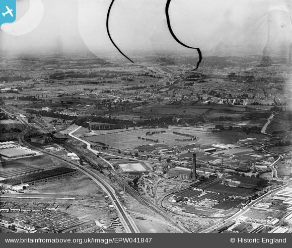
EPW041847 ENGLAND (1933). The Horse Ring football ground and various factories, Park Royal, from the south-east, 1933. This image has been produced from a damaged negative.
© Copyright OpenStreetMap contributors and licensed by the OpenStreetMap Foundation. 2025. Cartography is licensed as CC BY-SA.
Nearby Images (42)
Details
| Title | [EPW041847] The Horse Ring football ground and various factories, Park Royal, from the south-east, 1933. This image has been produced from a damaged negative. |
| Reference | EPW041847 |
| Date | June-1933 |
| Link | |
| Place name | PARK ROYAL |
| Parish | |
| District | |
| Country | ENGLAND |
| Easting / Northing | 519597, 182565 |
| Longitude / Latitude | -0.27570438293961, 51.528832978816 |
| National Grid Reference | TQ196826 |
Pins
 Leslie B |
Tuesday 11th of May 2021 03:01:28 PM | |
 gBr |
Thursday 26th of January 2017 09:24:59 PM | |
 gBr |
Thursday 26th of January 2017 09:21:59 PM | |
 gBr |
Thursday 26th of January 2017 09:18:28 PM | |
 Class31 |
Wednesday 19th of August 2015 11:38:49 AM | |
 Class31 |
Wednesday 19th of August 2015 09:23:42 AM |


![[EPW041847] The Horse Ring football ground and various factories, Park Royal, from the south-east, 1933. This image has been produced from a damaged negative.](http://britainfromabove.org.uk/sites/all/libraries/aerofilms-images/public/100x100/EPW/041/EPW041847.jpg)
![[EAW017054] The Mono Containers Ltd Carton Factory and environs, Park Royal, 1948. This image was marked by Aerofilms Ltd for photo editing.](http://britainfromabove.org.uk/sites/all/libraries/aerofilms-images/public/100x100/EAW/017/EAW017054.jpg)
![[EPW033754] The Mono Service Containers factory, Park Royal Football Ground and environs, Park Royal, 1930](http://britainfromabove.org.uk/sites/all/libraries/aerofilms-images/public/100x100/EPW/033/EPW033754.jpg)
![[EAW017055] The Mono Containers Ltd Carton Factory and environs, Park Royal, 1948](http://britainfromabove.org.uk/sites/all/libraries/aerofilms-images/public/100x100/EAW/017/EAW017055.jpg)
![[EAW017051] The Mono Containers Ltd Carton Factory and environs, Park Royal, 1948. This image was marked by Aerofilms Ltd for photo editing.](http://britainfromabove.org.uk/sites/all/libraries/aerofilms-images/public/100x100/EAW/017/EAW017051.jpg)
![[EPW033804] The Mono Service Containers factory, Park Royal Football Ground and environs, Park Royal, 1930](http://britainfromabove.org.uk/sites/all/libraries/aerofilms-images/public/100x100/EPW/033/EPW033804.jpg)
![[EAW017053] The Mono Containers Ltd Carton Factory and environs, Park Royal, 1948. This image was marked by Aerofilms Ltd for photo editing.](http://britainfromabove.org.uk/sites/all/libraries/aerofilms-images/public/100x100/EAW/017/EAW017053.jpg)
![[EPW033752] The Mono Service Containers factory and surrounding industrial units, Park Royal, 1930](http://britainfromabove.org.uk/sites/all/libraries/aerofilms-images/public/100x100/EPW/033/EPW033752.jpg)
![[EPW033753] The Mono Service Containers factory and the Horse Ring, Park Royal, 1930](http://britainfromabove.org.uk/sites/all/libraries/aerofilms-images/public/100x100/EPW/033/EPW033753.jpg)
![[EAW017048] The Mono Containers Ltd Carton Factory and environs, Park Royal, 1948. This image was marked by Aerofilms Ltd for photo editing.](http://britainfromabove.org.uk/sites/all/libraries/aerofilms-images/public/100x100/EAW/017/EAW017048.jpg)
![[EAW017050] The Mono Containers Ltd Carton Factory and environs, Park Royal, 1948. This image was marked by Aerofilms Ltd for photo editing.](http://britainfromabove.org.uk/sites/all/libraries/aerofilms-images/public/100x100/EAW/017/EAW017050.jpg)
![[EPW033748] The Mono Service Containers factory and surrounding industrial units, Park Royal, 1930](http://britainfromabove.org.uk/sites/all/libraries/aerofilms-images/public/100x100/EPW/033/EPW033748.jpg)
![[EPW033808] The Mono Service Containers factory, Park Royal Football Ground and environs, Park Royal, 1930](http://britainfromabove.org.uk/sites/all/libraries/aerofilms-images/public/100x100/EPW/033/EPW033808.jpg)
![[EPW055631] Mono Containers Ltd Carton Factory undergoing construction and the Guiness Brewery, Park Royal, 1937](http://britainfromabove.org.uk/sites/all/libraries/aerofilms-images/public/100x100/EPW/055/EPW055631.jpg)
![[EPW033810] The Mono Service Containers factory, the Horse Ring and environs, Park Royal, 1930](http://britainfromabove.org.uk/sites/all/libraries/aerofilms-images/public/100x100/EPW/033/EPW033810.jpg)
![[EPW055632] Mono Containers Ltd Carton Factory undergoing construction, the Guiness Brewery and surrounding works, Park Royal, 1937](http://britainfromabove.org.uk/sites/all/libraries/aerofilms-images/public/100x100/EPW/055/EPW055632.jpg)
![[EPW033806] The Mono Service Containers factory and surrounding industrial units, Park Royal, 1930](http://britainfromabove.org.uk/sites/all/libraries/aerofilms-images/public/100x100/EPW/033/EPW033806.jpg)
![[EPW033747] The Mono Service Containers factory and surrounding industrial units, Park Royal, 1930](http://britainfromabove.org.uk/sites/all/libraries/aerofilms-images/public/100x100/EPW/033/EPW033747.jpg)
![[EAW017047] The Mono Containers Ltd Carton Factory and environs, Park Royal, 1948. This image was marked by Aerofilms Ltd for photo editing.](http://britainfromabove.org.uk/sites/all/libraries/aerofilms-images/public/100x100/EAW/017/EAW017047.jpg)
![[EPW033805] The Mono Service Containers factory and environs, Park Royal, 1930](http://britainfromabove.org.uk/sites/all/libraries/aerofilms-images/public/100x100/EPW/033/EPW033805.jpg)
![[EAW017046] The Mono Containers Ltd Carton Factory and environs, Park Royal, 1948. This image was marked by Aerofilms Ltd for photo editing.](http://britainfromabove.org.uk/sites/all/libraries/aerofilms-images/public/100x100/EAW/017/EAW017046.jpg)
![[EPW033751] The Mono Service Containers factory and environs, Park Royal, 1930](http://britainfromabove.org.uk/sites/all/libraries/aerofilms-images/public/100x100/EPW/033/EPW033751.jpg)
![[EAW017049] The Mono Containers Ltd Carton Factory and environs, Park Royal, 1948. This image was marked by Aerofilms Ltd for photo editing.](http://britainfromabove.org.uk/sites/all/libraries/aerofilms-images/public/100x100/EAW/017/EAW017049.jpg)
![[EPW033809] The Mono Service Containers factory, Park Royal Football Ground and environs, Park Royal, 1930](http://britainfromabove.org.uk/sites/all/libraries/aerofilms-images/public/100x100/EPW/033/EPW033809.jpg)
![[EPW055633] Mono Containers Ltd Carton Factory undergoing construction and surrounding works, Park Royal, 1937](http://britainfromabove.org.uk/sites/all/libraries/aerofilms-images/public/100x100/EPW/055/EPW055633.jpg)
![[EPW033750] The Mono Service Containers factory, the Horse Ring and environs, Park Royal, 1930](http://britainfromabove.org.uk/sites/all/libraries/aerofilms-images/public/100x100/EPW/033/EPW033750.jpg)
![[EPW033749] The Mono Service Containers factory and surrounding industrial units, Park Royal, 1930](http://britainfromabove.org.uk/sites/all/libraries/aerofilms-images/public/100x100/EPW/033/EPW033749.jpg)
![[EPW033807] The Mono Service Containers factory and environs, Park Royal, 1930](http://britainfromabove.org.uk/sites/all/libraries/aerofilms-images/public/100x100/EPW/033/EPW033807.jpg)
![[EAW017052] The Mono Containers Ltd Carton Factory and environs, Park Royal, 1948. This image was marked by Aerofilms Ltd for photo editing.](http://britainfromabove.org.uk/sites/all/libraries/aerofilms-images/public/100x100/EAW/017/EAW017052.jpg)
![[EPW055630] Construction work on the Mono Containers Ltd Carton Factory, Park Royal, 1937](http://britainfromabove.org.uk/sites/all/libraries/aerofilms-images/public/100x100/EPW/055/EPW055630.jpg)
![[EPW033746] The Mono Service Containers factory and surrounding industrial units, Park Royal, 1930](http://britainfromabove.org.uk/sites/all/libraries/aerofilms-images/public/100x100/EPW/033/EPW033746.jpg)
![[EPW041846] The Horse Ring football ground and various factories, Park Royal, from the south-east, 1933](http://britainfromabove.org.uk/sites/all/libraries/aerofilms-images/public/100x100/EPW/041/EPW041846.jpg)
![[EPW041853] The Horse Ring football ground and various factories, Park Royal, from the south-east, 1933](http://britainfromabove.org.uk/sites/all/libraries/aerofilms-images/public/100x100/EPW/041/EPW041853.jpg)
![[EPW041858] The Horse Ring football ground and various factories, Park Royal, from the south-east, 1933](http://britainfromabove.org.uk/sites/all/libraries/aerofilms-images/public/100x100/EPW/041/EPW041858.jpg)
![[EPW048435] The Guinness Brewery under construction, Park Royal, 1935](http://britainfromabove.org.uk/sites/all/libraries/aerofilms-images/public/100x100/EPW/048/EPW048435.jpg)
![[EPW041860] The Horse Ring football ground, Park Royal, 1933. This image has been produced from a damaged negative.](http://britainfromabove.org.uk/sites/all/libraries/aerofilms-images/public/100x100/EPW/041/EPW041860.jpg)
![[EPW041850] The Horse Ring football ground, Park Royal, 1933](http://britainfromabove.org.uk/sites/all/libraries/aerofilms-images/public/100x100/EPW/041/EPW041850.jpg)
![[EAW031549] The Guinness Brewery and environs, Park Royal, 1950. This image has been produced from a print.](http://britainfromabove.org.uk/sites/all/libraries/aerofilms-images/public/100x100/EAW/031/EAW031549.jpg)
![[EPW041852] The Horse Ring football ground, Park Royal, 1933](http://britainfromabove.org.uk/sites/all/libraries/aerofilms-images/public/100x100/EPW/041/EPW041852.jpg)
![[EPW041857] The Horse Ring football ground, Park Royal, 1933](http://britainfromabove.org.uk/sites/all/libraries/aerofilms-images/public/100x100/EPW/041/EPW041857.jpg)
![[EAW031552] The Guinness Brewery, Park Royal, 1950. This image has been produced from a print marked by Aerofilms Ltd for photo editing.](http://britainfromabove.org.uk/sites/all/libraries/aerofilms-images/public/100x100/EAW/031/EAW031552.jpg)
![[EPW041851] The Horse Ring football ground and various factories, Park Royal, 1933](http://britainfromabove.org.uk/sites/all/libraries/aerofilms-images/public/100x100/EPW/041/EPW041851.jpg)