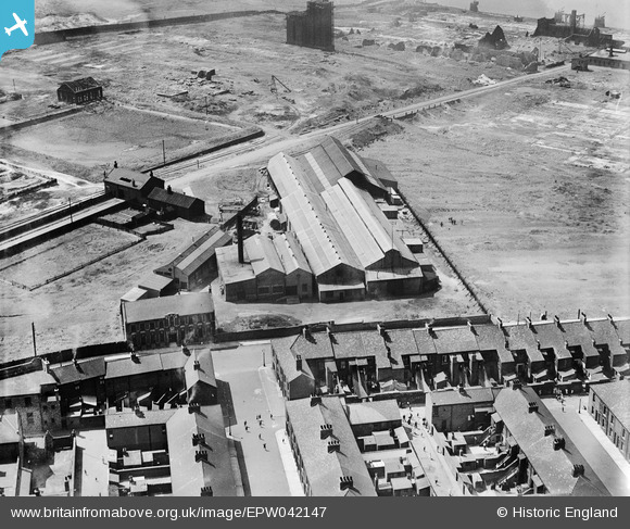
EPW042147 ENGLAND (1933). White's Marine Engineering Works, Hebburn, 1933
© Copyright OpenStreetMap contributors and licensed by the OpenStreetMap Foundation. 2025. Cartography is licensed as CC BY-SA.
Nearby Images (9)
Details
| Title | [EPW042147] White's Marine Engineering Works, Hebburn, 1933 |
| Reference | EPW042147 |
| Date | July-1933 |
| Link | |
| Place name | HEBBURN |
| Parish | |
| District | |
| Country | ENGLAND |
| Easting / Northing | 430529, 564821 |
| Longitude / Latitude | -1.5229746796798, 54.976986478143 |
| National Grid Reference | NZ305648 |
Pins
 N Dunn |
Sunday 8th of September 2013 10:10:30 AM | |
 N Dunn |
Tuesday 3rd of September 2013 10:01:14 AM | |
 N Dunn |
Tuesday 3rd of September 2013 09:57:27 AM | |
 N Dunn |
Tuesday 3rd of September 2013 09:54:39 AM | |
 N Dunn |
Tuesday 3rd of September 2013 09:53:38 AM | |
 N Dunn |
Tuesday 3rd of September 2013 09:53:00 AM | |
 N Dunn |
Tuesday 3rd of September 2013 09:52:05 AM | |
 N Dunn |
Tuesday 3rd of September 2013 09:50:06 AM | |
 N Dunn |
Tuesday 3rd of September 2013 09:49:46 AM |


![[EPW042147] White's Marine Engineering Works, Hebburn, 1933](http://britainfromabove.org.uk/sites/all/libraries/aerofilms-images/public/100x100/EPW/042/EPW042147.jpg)
![[EPW042143] White's Marine Engineering Works, Hebburn, 1933](http://britainfromabove.org.uk/sites/all/libraries/aerofilms-images/public/100x100/EPW/042/EPW042143.jpg)
![[EPW042146] White's Marine Engineering Works and environs, Hebburn, 1933](http://britainfromabove.org.uk/sites/all/libraries/aerofilms-images/public/100x100/EPW/042/EPW042146.jpg)
![[EPW042144] White's Marine Engineering Works, Prince Consort Road and the Bauxite Works, Hebburn, 1933](http://britainfromabove.org.uk/sites/all/libraries/aerofilms-images/public/100x100/EPW/042/EPW042144.jpg)
![[EPW042142] White's Marine Engineering Works, Hebburn, 1933](http://britainfromabove.org.uk/sites/all/libraries/aerofilms-images/public/100x100/EPW/042/EPW042142.jpg)
![[EPW042145] White's Marine Engineering Works and Prince Consort Road, Hebburn, 1933](http://britainfromabove.org.uk/sites/all/libraries/aerofilms-images/public/100x100/EPW/042/EPW042145.jpg)
![[EPW019890] Cuthbert Street and environs, Hebburn, 1927](http://britainfromabove.org.uk/sites/all/libraries/aerofilms-images/public/100x100/EPW/019/EPW019890.jpg)
![[EPW019891] The Bauxite Works, Hebburn, 1927](http://britainfromabove.org.uk/sites/all/libraries/aerofilms-images/public/100x100/EPW/019/EPW019891.jpg)
![[EPW049191] The Reyrolle Electrical Engineering Works, Hebburn, 1935](http://britainfromabove.org.uk/sites/all/libraries/aerofilms-images/public/100x100/EPW/049/EPW049191.jpg)