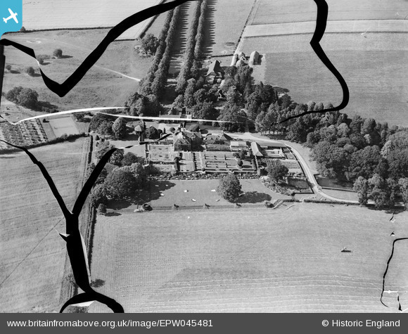
EPW045481 ENGLAND (1934). Isfield Place, Isfield, 1934. This image has been produced from a damaged negative.
© Copyright OpenStreetMap contributors and licensed by the OpenStreetMap Foundation. 2025. Cartography is licensed as CC BY-SA.
Nearby Images (43)
Details
| Title | [EPW045481] Isfield Place, Isfield, 1934. This image has been produced from a damaged negative. |
| Reference | EPW045481 |
| Date | July-1934 |
| Link | |
| Place name | ISFIELD |
| Parish | ISFIELD |
| District | |
| Country | ENGLAND |
| Easting / Northing | 544641, 118436 |
| Longitude / Latitude | 0.059233639390416, 50.946643625719 |
| National Grid Reference | TQ446184 |
Pins
Be the first to add a comment to this image!


![[EPW045481] Isfield Place, Isfield, 1934. This image has been produced from a damaged negative.](http://britainfromabove.org.uk/sites/all/libraries/aerofilms-images/public/100x100/EPW/045/EPW045481.jpg)
![[EPW034503] Isfield Place, Isfield, 1930](http://britainfromabove.org.uk/sites/all/libraries/aerofilms-images/public/100x100/EPW/034/EPW034503.jpg)
![[EPW035188] Isfield Place, Isfield, 1931](http://britainfromabove.org.uk/sites/all/libraries/aerofilms-images/public/100x100/EPW/035/EPW035188.jpg)
![[EPW034498] Isfield Place, Isfield, 1930](http://britainfromabove.org.uk/sites/all/libraries/aerofilms-images/public/100x100/EPW/034/EPW034498.jpg)
![[EPW034501] Isfield Place and environs, Isfield, 1930](http://britainfromabove.org.uk/sites/all/libraries/aerofilms-images/public/100x100/EPW/034/EPW034501.jpg)
![[EPW034507] Isfield Place, Isfield, 1930](http://britainfromabove.org.uk/sites/all/libraries/aerofilms-images/public/100x100/EPW/034/EPW034507.jpg)
![[EPW034509] Isfield Place, Isfield, 1930](http://britainfromabove.org.uk/sites/all/libraries/aerofilms-images/public/100x100/EPW/034/EPW034509.jpg)
![[EPW034508] Isfield Place and environs, Isfield, 1930](http://britainfromabove.org.uk/sites/all/libraries/aerofilms-images/public/100x100/EPW/034/EPW034508.jpg)
![[EPW045473] Isfield Place, Isfield, 1934. This image has been produced from a damaged negative.](http://britainfromabove.org.uk/sites/all/libraries/aerofilms-images/public/100x100/EPW/045/EPW045473.jpg)
![[EPW045477] Isfield Place, Isfield, 1934. This image has been produced from a damaged negative.](http://britainfromabove.org.uk/sites/all/libraries/aerofilms-images/public/100x100/EPW/045/EPW045477.jpg)
![[EPW046011] Isfield Place, Isfield, 1934](http://britainfromabove.org.uk/sites/all/libraries/aerofilms-images/public/100x100/EPW/046/EPW046011.jpg)
![[EPW034506] Isfield Place, Isfield, 1930](http://britainfromabove.org.uk/sites/all/libraries/aerofilms-images/public/100x100/EPW/034/EPW034506.jpg)
![[EPW035178] Isfield Place, Isfield, 1931](http://britainfromabove.org.uk/sites/all/libraries/aerofilms-images/public/100x100/EPW/035/EPW035178.jpg)
![[EPW035187] Isfield Place, Isfield, 1931](http://britainfromabove.org.uk/sites/all/libraries/aerofilms-images/public/100x100/EPW/035/EPW035187.jpg)
![[EPW035176] Isfield Place, Isfield, 1931](http://britainfromabove.org.uk/sites/all/libraries/aerofilms-images/public/100x100/EPW/035/EPW035176.jpg)
![[EPW035186] Isfield Place, Isfield, 1931](http://britainfromabove.org.uk/sites/all/libraries/aerofilms-images/public/100x100/EPW/035/EPW035186.jpg)
![[EPW046010] Isfield Place, Isfield, 1934](http://britainfromabove.org.uk/sites/all/libraries/aerofilms-images/public/100x100/EPW/046/EPW046010.jpg)
![[EPW046012] Isfield Place, Isfield, 1934](http://britainfromabove.org.uk/sites/all/libraries/aerofilms-images/public/100x100/EPW/046/EPW046012.jpg)
![[EPW035174] Isfield Place, Isfield, 1931](http://britainfromabove.org.uk/sites/all/libraries/aerofilms-images/public/100x100/EPW/035/EPW035174.jpg)
![[EPW035177] Isfield Place, Isfield, 1931](http://britainfromabove.org.uk/sites/all/libraries/aerofilms-images/public/100x100/EPW/035/EPW035177.jpg)
![[EPW035175] Isfield Place, Isfield, 1931](http://britainfromabove.org.uk/sites/all/libraries/aerofilms-images/public/100x100/EPW/035/EPW035175.jpg)
![[EPW035185] Isfield Place, Isfield, 1931](http://britainfromabove.org.uk/sites/all/libraries/aerofilms-images/public/100x100/EPW/035/EPW035185.jpg)
![[EPW034500] Isfield Place, Isfield, 1930](http://britainfromabove.org.uk/sites/all/libraries/aerofilms-images/public/100x100/EPW/034/EPW034500.jpg)
![[EPW034504] Isfield Place and environs, Isfield, 1930](http://britainfromabove.org.uk/sites/all/libraries/aerofilms-images/public/100x100/EPW/034/EPW034504.jpg)
![[EPW034502] Isfield Place, Isfield, 1930](http://britainfromabove.org.uk/sites/all/libraries/aerofilms-images/public/100x100/EPW/034/EPW034502.jpg)
![[EPW035182] Isfield Place, Isfield, 1931](http://britainfromabove.org.uk/sites/all/libraries/aerofilms-images/public/100x100/EPW/035/EPW035182.jpg)
![[EPW046007] Isfield Place, Isfield, 1934](http://britainfromabove.org.uk/sites/all/libraries/aerofilms-images/public/100x100/EPW/046/EPW046007.jpg)
![[EPW035181] Isfield Place, Isfield, 1931](http://britainfromabove.org.uk/sites/all/libraries/aerofilms-images/public/100x100/EPW/035/EPW035181.jpg)
![[EPW035189] Isfield Place, Isfield, 1931](http://britainfromabove.org.uk/sites/all/libraries/aerofilms-images/public/100x100/EPW/035/EPW035189.jpg)
![[EPW045479] Isfield Place, Isfield, 1934. This image has been produced from a damaged negative.](http://britainfromabove.org.uk/sites/all/libraries/aerofilms-images/public/100x100/EPW/045/EPW045479.jpg)
![[EPW035183] Isfield Place, Isfield, 1931](http://britainfromabove.org.uk/sites/all/libraries/aerofilms-images/public/100x100/EPW/035/EPW035183.jpg)
![[EPW046008] Isfield Place, Isfield, 1934](http://britainfromabove.org.uk/sites/all/libraries/aerofilms-images/public/100x100/EPW/046/EPW046008.jpg)
![[EPW046009] Isfield Place, Isfield, 1934](http://britainfromabove.org.uk/sites/all/libraries/aerofilms-images/public/100x100/EPW/046/EPW046009.jpg)
![[EPW045480] Isfield Place and surrounding countryside, Isfield, from the south, 1934. This image has been produced from a damaged negative.](http://britainfromabove.org.uk/sites/all/libraries/aerofilms-images/public/100x100/EPW/045/EPW045480.jpg)
![[EPW045478] Isfield Place, Isfield, 1934. This image has been produced from a damaged negative.](http://britainfromabove.org.uk/sites/all/libraries/aerofilms-images/public/100x100/EPW/045/EPW045478.jpg)
![[EPW045476] Isfield Place and surrounding countryside, Isfield, from the south, 1934. This image has been produced from a damaged negative.](http://britainfromabove.org.uk/sites/all/libraries/aerofilms-images/public/100x100/EPW/045/EPW045476.jpg)
![[EPW045474] Isfield Place and surrounding countryside, Isfield, from the south, 1934. This image has been produced from a damaged negative.](http://britainfromabove.org.uk/sites/all/libraries/aerofilms-images/public/100x100/EPW/045/EPW045474.jpg)
![[EPW035179] Isfield Place and environs, Isfield, 1931](http://britainfromabove.org.uk/sites/all/libraries/aerofilms-images/public/100x100/EPW/035/EPW035179.jpg)
![[EPW045472] Isfield Place and surrounding countryside, Isfield, from the south-west, 1934. This image has been produced from a damaged negative.](http://britainfromabove.org.uk/sites/all/libraries/aerofilms-images/public/100x100/EPW/045/EPW045472.jpg)
![[EPW035180] Isfield Place and environs, Isfield, 1931](http://britainfromabove.org.uk/sites/all/libraries/aerofilms-images/public/100x100/EPW/035/EPW035180.jpg)
![[EPW045471] St Margaret's Church, Isfield Place and surrounding countryside, Isfield, from the south-west, 1934. This image has been produced from a damaged negative.](http://britainfromabove.org.uk/sites/all/libraries/aerofilms-images/public/100x100/EPW/045/EPW045471.jpg)
![[EPW045475] Isfield Mill, Isfield Place and surrounding countryside, Isfield, from the south-east, 1934. This image has been produced from a damaged negative.](http://britainfromabove.org.uk/sites/all/libraries/aerofilms-images/public/100x100/EPW/045/EPW045475.jpg)
![[EPW034499] Isfield Place and environs, Isfield, from the south-east, 1930](http://britainfromabove.org.uk/sites/all/libraries/aerofilms-images/public/100x100/EPW/034/EPW034499.jpg)