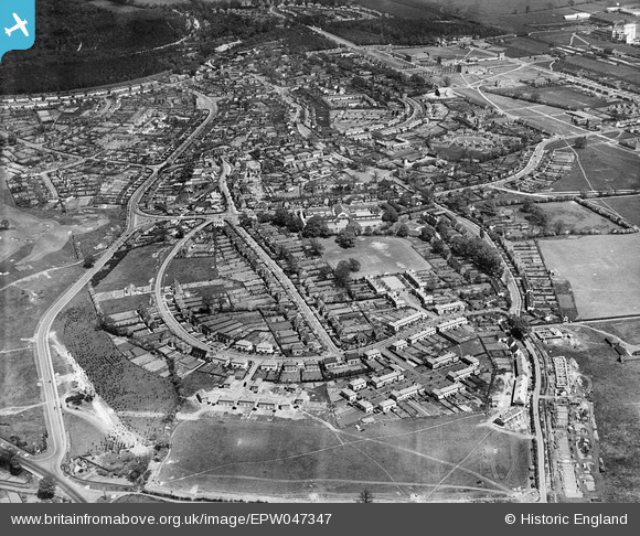
EPW047347 ENGLAND (1935). Handside, Welwyn Garden City, 1935
© Copyright OpenStreetMap contributors and licensed by the OpenStreetMap Foundation. 2025. Cartography is licensed as CC BY-SA.
Nearby Images (14)
Details
| Title | [EPW047347] Handside, Welwyn Garden City, 1935 |
| Reference | EPW047347 |
| Date | May-1935 |
| Link | |
| Place name | WELWYN GARDEN CITY |
| Parish | |
| District | |
| Country | ENGLAND |
| Easting / Northing | 522865, 212419 |
| Longitude / Latitude | -0.21811439002482, 51.796456908878 |
| National Grid Reference | TL229124 |


![[EPW047347] Handside, Welwyn Garden City, 1935](http://britainfromabove.org.uk/sites/all/libraries/aerofilms-images/public/100x100/EPW/047/EPW047347.jpg)
![[EPW047349] Elmwood and environs, Welwyn Garden City, 1935](http://britainfromabove.org.uk/sites/all/libraries/aerofilms-images/public/100x100/EPW/047/EPW047349.jpg)
![[EPW054508] Applecroft Primary School (formerly Handside School), Handside, 1937](http://britainfromabove.org.uk/sites/all/libraries/aerofilms-images/public/100x100/EPW/054/EPW054508.jpg)
![[EPW047348] Handside, Welwyn Garden City, 1935](http://britainfromabove.org.uk/sites/all/libraries/aerofilms-images/public/100x100/EPW/047/EPW047348.jpg)
![[EPW047350] Elmwood and environs, Welwyn Garden City, 1935](http://britainfromabove.org.uk/sites/all/libraries/aerofilms-images/public/100x100/EPW/047/EPW047350.jpg)
![[EPW025530] Applecroft Primary School, Welwyn Garden City, 1928](http://britainfromabove.org.uk/sites/all/libraries/aerofilms-images/public/100x100/EPW/025/EPW025530.jpg)
![[EAW035465] The town and surrounding countryside, Welwyn Garden City, from the west, 1951. This image has been produced from a print marked by Aerofilms Ltd for photo editing.](http://britainfromabove.org.uk/sites/all/libraries/aerofilms-images/public/100x100/EAW/035/EAW035465.jpg)
![[EPW022039] Elmwood and Attimore Road residences, Welwyn Garden City, 1928](http://britainfromabove.org.uk/sites/all/libraries/aerofilms-images/public/100x100/EPW/022/EPW022039.jpg)
![[EPW025529] The residential area at Handside, Welwyn Garden City, 1928. This image has been produced from a copy-negative.](http://britainfromabove.org.uk/sites/all/libraries/aerofilms-images/public/100x100/EPW/025/EPW025529.jpg)
![[EAW035462] The town and surrounding countryside, Welwyn Garden City, from the west, 1951. This image has been produced from a print marked by Aerofilms Ltd for photo editing.](http://britainfromabove.org.uk/sites/all/libraries/aerofilms-images/public/100x100/EAW/035/EAW035462.jpg)
![[EAW020865] Smoke rising from a distant chimney beyond the town, Welwyn Garden City, from the south-west, 1949. This image has been produced from a damaged negative.](http://britainfromabove.org.uk/sites/all/libraries/aerofilms-images/public/100x100/EAW/020/EAW020865.jpg)
![[EPW013426] The residential area at Handside under construction, Welwyn Garden City, 1925. This image has been produced from a copy-negative.](http://britainfromabove.org.uk/sites/all/libraries/aerofilms-images/public/100x100/EPW/013/EPW013426.jpg)
![[EPW009815] Handside Lane and surroundings, Welwyn Garden City, 1924](http://britainfromabove.org.uk/sites/all/libraries/aerofilms-images/public/100x100/EPW/009/EPW009815.jpg)
![[EPW022037] Elmwood and Attimore Road residences, Welwyn Garden City, 1928](http://britainfromabove.org.uk/sites/all/libraries/aerofilms-images/public/100x100/EPW/022/EPW022037.jpg)
