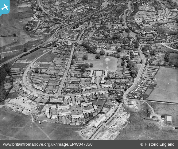
EPW047350 ENGLAND (1935). Elmwood and environs, Welwyn Garden City, 1935
© Copyright OpenStreetMap contributors and licensed by the OpenStreetMap Foundation. 2025. Cartography is licensed as CC BY-SA.
Nearby Images (13)
Details
| Title | [EPW047350] Elmwood and environs, Welwyn Garden City, 1935 |
| Reference | EPW047350 |
| Date | May-1935 |
| Link | |
| Place name | WELWYN GARDEN CITY |
| Parish | |
| District | |
| Country | ENGLAND |
| Easting / Northing | 522838, 212318 |
| Longitude / Latitude | -0.21854154276978, 51.795555082714 |
| National Grid Reference | TL228123 |
Pins
Be the first to add a comment to this image!


![[EPW047350] Elmwood and environs, Welwyn Garden City, 1935](http://britainfromabove.org.uk/sites/all/libraries/aerofilms-images/public/100x100/EPW/047/EPW047350.jpg)
![[EPW047348] Handside, Welwyn Garden City, 1935](http://britainfromabove.org.uk/sites/all/libraries/aerofilms-images/public/100x100/EPW/047/EPW047348.jpg)
![[EPW047349] Elmwood and environs, Welwyn Garden City, 1935](http://britainfromabove.org.uk/sites/all/libraries/aerofilms-images/public/100x100/EPW/047/EPW047349.jpg)
![[EPW022039] Elmwood and Attimore Road residences, Welwyn Garden City, 1928](http://britainfromabove.org.uk/sites/all/libraries/aerofilms-images/public/100x100/EPW/022/EPW022039.jpg)
![[EPW047347] Handside, Welwyn Garden City, 1935](http://britainfromabove.org.uk/sites/all/libraries/aerofilms-images/public/100x100/EPW/047/EPW047347.jpg)
![[EPW047343] The town, Welwyn Garden City, from the south-west, 1935](http://britainfromabove.org.uk/sites/all/libraries/aerofilms-images/public/100x100/EPW/047/EPW047343.jpg)
![[EPW022037] Elmwood and Attimore Road residences, Welwyn Garden City, 1928](http://britainfromabove.org.uk/sites/all/libraries/aerofilms-images/public/100x100/EPW/022/EPW022037.jpg)
![[EPW025530] Applecroft Primary School, Welwyn Garden City, 1928](http://britainfromabove.org.uk/sites/all/libraries/aerofilms-images/public/100x100/EPW/025/EPW025530.jpg)
![[EPW054508] Applecroft Primary School (formerly Handside School), Handside, 1937](http://britainfromabove.org.uk/sites/all/libraries/aerofilms-images/public/100x100/EPW/054/EPW054508.jpg)
![[EAW035462] The town and surrounding countryside, Welwyn Garden City, from the west, 1951. This image has been produced from a print marked by Aerofilms Ltd for photo editing.](http://britainfromabove.org.uk/sites/all/libraries/aerofilms-images/public/100x100/EAW/035/EAW035462.jpg)
![[EPW025534] Handside, Welwyn Garden City, from the south, 1928. This image has been produced from a damaged negative.](http://britainfromabove.org.uk/sites/all/libraries/aerofilms-images/public/100x100/EPW/025/EPW025534.jpg)
![[EAW035465] The town and surrounding countryside, Welwyn Garden City, from the west, 1951. This image has been produced from a print marked by Aerofilms Ltd for photo editing.](http://britainfromabove.org.uk/sites/all/libraries/aerofilms-images/public/100x100/EAW/035/EAW035465.jpg)
![[EPW025529] The residential area at Handside, Welwyn Garden City, 1928. This image has been produced from a copy-negative.](http://britainfromabove.org.uk/sites/all/libraries/aerofilms-images/public/100x100/EPW/025/EPW025529.jpg)