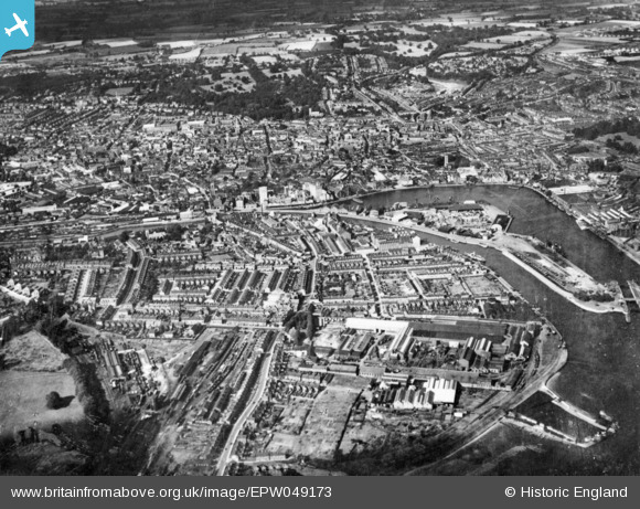
EPW049173 ENGLAND (1935). Wet Dock and the town, Ipswich, 1935. This image has been produced from a copy-negative.
© Copyright OpenStreetMap contributors and licensed by the OpenStreetMap Foundation. 2025. Cartography is licensed as CC BY-SA.
Nearby Images (17)
Details
| Title | [EPW049173] Wet Dock and the town, Ipswich, 1935. This image has been produced from a copy-negative. |
| Reference | EPW049173 |
| Date | September-1935 |
| Link | |
| Place name | IPSWICH |
| Parish | |
| District | |
| Country | ENGLAND |
| Easting / Northing | 616526, 243760 |
| Longitude / Latitude | 1.1582037280289, 52.04944077556 |
| National Grid Reference | TM165438 |
Pins
Be the first to add a comment to this image!


![[EPW049173] Wet Dock and the town, Ipswich, 1935. This image has been produced from a copy-negative.](http://britainfromabove.org.uk/sites/all/libraries/aerofilms-images/public/100x100/EPW/049/EPW049173.jpg)
![[EAW033334] Ipswich Dock, New Cut and the town, Ipswich, 1950](http://britainfromabove.org.uk/sites/all/libraries/aerofilms-images/public/100x100/EAW/033/EAW033334.jpg)
![[EAW053511] The town and docks, Ipswich, 1954](http://britainfromabove.org.uk/sites/all/libraries/aerofilms-images/public/100x100/EAW/053/EAW053511.jpg)
![[EPW041351] Stoke Bridge and environs, Ipswich, 1933](http://britainfromabove.org.uk/sites/all/libraries/aerofilms-images/public/100x100/EPW/041/EPW041351.jpg)
![[EPW041352] Stoke Bridge and environs, Ipswich, 1933](http://britainfromabove.org.uk/sites/all/libraries/aerofilms-images/public/100x100/EPW/041/EPW041352.jpg)
![[EPW041353] The New Cut at Stoke Bridge and environs, Ipswich, 1933](http://britainfromabove.org.uk/sites/all/libraries/aerofilms-images/public/100x100/EPW/041/EPW041353.jpg)
![[EPW005253] Ipswich and the Common Quay, Ipswich, from the south, 1921](http://britainfromabove.org.uk/sites/all/libraries/aerofilms-images/public/100x100/EPW/005/EPW005253.jpg)
![[EPW041350] Stoke Bridge, Stoke Bridge Wharf and environs, Ipswich, 1933](http://britainfromabove.org.uk/sites/all/libraries/aerofilms-images/public/100x100/EPW/041/EPW041350.jpg)
![[EPW058767] The William Brown & Co (Ipswich) Ltd timber works, Three Cranes Wharf and New Cut East, Ipswich, 1938](http://britainfromabove.org.uk/sites/all/libraries/aerofilms-images/public/100x100/EPW/058/EPW058767.jpg)
![[EPW058747] Wet Dock, New Cut and environs, Ipswich, 1938](http://britainfromabove.org.uk/sites/all/libraries/aerofilms-images/public/100x100/EPW/058/EPW058747.jpg)
![[EPW032856] Tovell's Wharf and environs, Ipswich, 1930](http://britainfromabove.org.uk/sites/all/libraries/aerofilms-images/public/100x100/EPW/032/EPW032856.jpg)
![[EPW058766] The William Brown & Co (Ipswich) Ltd timber works, Three Cranes Wharf and environs, Ipswich, 1938](http://britainfromabove.org.uk/sites/all/libraries/aerofilms-images/public/100x100/EPW/058/EPW058766.jpg)
![[EPW058768] The William Brown & Co (Ipswich) Ltd timber works, Wet Dock and environs, Ipswich, 1938](http://britainfromabove.org.uk/sites/all/libraries/aerofilms-images/public/100x100/EPW/058/EPW058768.jpg)
![[EPW058765] The William Brown & Co (Ipswich) Ltd timber works, Wet Dock and environs, Ipswich, 1938](http://britainfromabove.org.uk/sites/all/libraries/aerofilms-images/public/100x100/EPW/058/EPW058765.jpg)
![[EPW032845] The docks, Ipswich, 1930](http://britainfromabove.org.uk/sites/all/libraries/aerofilms-images/public/100x100/EPW/032/EPW032845.jpg)
![[EAW033331] Ipswich Dock, New Cut and Stoke, Ipswich, 1950](http://britainfromabove.org.uk/sites/all/libraries/aerofilms-images/public/100x100/EAW/033/EAW033331.jpg)
![[EPW032832] Tovell's Wharf and Common Quay, Ipswich, 1930](http://britainfromabove.org.uk/sites/all/libraries/aerofilms-images/public/100x100/EPW/032/EPW032832.jpg)