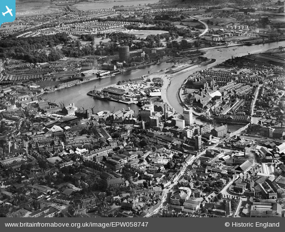
EPW058747 ENGLAND (1938). Wet Dock, New Cut and environs, Ipswich, 1938
© Copyright OpenStreetMap contributors and licensed by the OpenStreetMap Foundation. 2025. Cartography is licensed as CC BY-SA.
Nearby Images (19)
Details
| Title | [EPW058747] Wet Dock, New Cut and environs, Ipswich, 1938 |
| Reference | EPW058747 |
| Date | 23-August-1938 |
| Link | |
| Place name | IPSWICH |
| Parish | |
| District | |
| Country | ENGLAND |
| Easting / Northing | 616568, 244006 |
| Longitude / Latitude | 1.1589712245601, 52.051632952593 |
| National Grid Reference | TM166440 |
Pins
Be the first to add a comment to this image!


![[EPW058747] Wet Dock, New Cut and environs, Ipswich, 1938](http://britainfromabove.org.uk/sites/all/libraries/aerofilms-images/public/100x100/EPW/058/EPW058747.jpg)
![[EPW041352] Stoke Bridge and environs, Ipswich, 1933](http://britainfromabove.org.uk/sites/all/libraries/aerofilms-images/public/100x100/EPW/041/EPW041352.jpg)
![[EPW041351] Stoke Bridge and environs, Ipswich, 1933](http://britainfromabove.org.uk/sites/all/libraries/aerofilms-images/public/100x100/EPW/041/EPW041351.jpg)
![[EPW041353] The New Cut at Stoke Bridge and environs, Ipswich, 1933](http://britainfromabove.org.uk/sites/all/libraries/aerofilms-images/public/100x100/EPW/041/EPW041353.jpg)
![[EPW041350] Stoke Bridge, Stoke Bridge Wharf and environs, Ipswich, 1933](http://britainfromabove.org.uk/sites/all/libraries/aerofilms-images/public/100x100/EPW/041/EPW041350.jpg)
![[EPW005253] Ipswich and the Common Quay, Ipswich, from the south, 1921](http://britainfromabove.org.uk/sites/all/libraries/aerofilms-images/public/100x100/EPW/005/EPW005253.jpg)
![[EAW053511] The town and docks, Ipswich, 1954](http://britainfromabove.org.uk/sites/all/libraries/aerofilms-images/public/100x100/EAW/053/EAW053511.jpg)
![[EPW032832] Tovell's Wharf and Common Quay, Ipswich, 1930](http://britainfromabove.org.uk/sites/all/libraries/aerofilms-images/public/100x100/EPW/032/EPW032832.jpg)
![[EPW032873] The town, Ipswich, from the south-east, 1930](http://britainfromabove.org.uk/sites/all/libraries/aerofilms-images/public/100x100/EPW/032/EPW032873.jpg)
![[EPW058767] The William Brown & Co (Ipswich) Ltd timber works, Three Cranes Wharf and New Cut East, Ipswich, 1938](http://britainfromabove.org.uk/sites/all/libraries/aerofilms-images/public/100x100/EPW/058/EPW058767.jpg)
![[EPW058746] Stoke Bridge, St Peter's Church and environs, Ipswich, 1938](http://britainfromabove.org.uk/sites/all/libraries/aerofilms-images/public/100x100/EPW/058/EPW058746.jpg)
![[EPW032845] The docks, Ipswich, 1930](http://britainfromabove.org.uk/sites/all/libraries/aerofilms-images/public/100x100/EPW/032/EPW032845.jpg)
![[EPW058766] The William Brown & Co (Ipswich) Ltd timber works, Three Cranes Wharf and environs, Ipswich, 1938](http://britainfromabove.org.uk/sites/all/libraries/aerofilms-images/public/100x100/EPW/058/EPW058766.jpg)
![[EPW058765] The William Brown & Co (Ipswich) Ltd timber works, Wet Dock and environs, Ipswich, 1938](http://britainfromabove.org.uk/sites/all/libraries/aerofilms-images/public/100x100/EPW/058/EPW058765.jpg)
![[EPW058768] The William Brown & Co (Ipswich) Ltd timber works, Wet Dock and environs, Ipswich, 1938](http://britainfromabove.org.uk/sites/all/libraries/aerofilms-images/public/100x100/EPW/058/EPW058768.jpg)
![[EPW049173] Wet Dock and the town, Ipswich, 1935. This image has been produced from a copy-negative.](http://britainfromabove.org.uk/sites/all/libraries/aerofilms-images/public/100x100/EPW/049/EPW049173.jpg)
![[EPW058764] The William Brown & Co (Ipswich) Ltd timber works, Wet Dock and environs, Ipswich, 1938](http://britainfromabove.org.uk/sites/all/libraries/aerofilms-images/public/100x100/EPW/058/EPW058764.jpg)
![[EPW032856] Tovell's Wharf and environs, Ipswich, 1930](http://britainfromabove.org.uk/sites/all/libraries/aerofilms-images/public/100x100/EPW/032/EPW032856.jpg)
![[EPW058769] The William Brown & Co (Ipswich) Ltd timber works, Three Cranes Wharf and environs, Ipswich, 1938](http://britainfromabove.org.uk/sites/all/libraries/aerofilms-images/public/100x100/EPW/058/EPW058769.jpg)