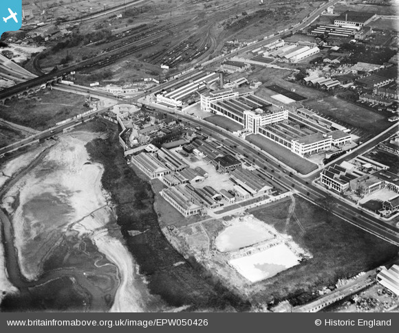
EPW050426 ENGLAND (1936). The Kemps Biscuit Factory on the North Circular Road and environs, Dollis Hill, 1936
© Copyright OpenStreetMap contributors and licensed by the OpenStreetMap Foundation. 2024. Cartography is licensed as CC BY-SA.
Nearby Images (38)
Details
| Title | [EPW050426] The Kemps Biscuit Factory on the North Circular Road and environs, Dollis Hill, 1936 |
| Reference | EPW050426 |
| Date | June-1936 |
| Link | |
| Place name | DOLLIS HILL |
| Parish | |
| District | |
| Country | ENGLAND |
| Easting / Northing | 522398, 187223 |
| Longitude / Latitude | -0.2337202139022, 51.570099500244 |
| National Grid Reference | TQ224872 |
Pins
Be the first to add a comment to this image!


![[EPW050426] The Kemps Biscuit Factory on the North Circular Road and environs, Dollis Hill, 1936](http://britainfromabove.org.uk/sites/all/libraries/aerofilms-images/public/100x100/EPW/050/EPW050426.jpg)
![[EAW048510] The Rockwell Machine Tool Co Ltd Works on Hendon Broadway and nearby factories along the North Circular Road, Dollis Hill, 1953. This image was marked by Aerofilms Ltd for photo editing.](http://britainfromabove.org.uk/sites/all/libraries/aerofilms-images/public/100x100/EAW/048/EAW048510.jpg)
![[EPW020220] Allen-Liversidge Limited works and Brent Reservoir, Dollis Hill, 1928](http://britainfromabove.org.uk/sites/all/libraries/aerofilms-images/public/100x100/EPW/020/EPW020220.jpg)
![[EPW032152] The Allen-Liversidge Oxygen Works, Dollis Hill, 1930](http://britainfromabove.org.uk/sites/all/libraries/aerofilms-images/public/100x100/EPW/032/EPW032152.jpg)
![[EPW032153] The Allen-Liversidge Oxygen Works, Dollis Hill, 1930](http://britainfromabove.org.uk/sites/all/libraries/aerofilms-images/public/100x100/EPW/032/EPW032153.jpg)
![[EPW032151] Scribbans-Kemp Biscuit Factory, the Allen-Liversidge Oxygen Works and the Brent Reservoir, Dollis Hill, 1930](http://britainfromabove.org.uk/sites/all/libraries/aerofilms-images/public/100x100/EPW/032/EPW032151.jpg)
![[EAW048511] The Rockwell Machine Tool Co Ltd Works on Hendon Broadway and nearby factories along the North Circular Road, Dollis Hill, 1953. This image was marked by Aerofilms Ltd for photo editing.](http://britainfromabove.org.uk/sites/all/libraries/aerofilms-images/public/100x100/EAW/048/EAW048511.jpg)
![[EPW020221] Allen-Liversidge Limited works and Brent Reservoir, Dollis Hill, 1928](http://britainfromabove.org.uk/sites/all/libraries/aerofilms-images/public/100x100/EPW/020/EPW020221.jpg)
![[EAW048506] The Rockwell Machine Tool Co Ltd Works on Hendon Broadway and nearby factories along the North Circular Road, Dollis Hill, 1953. This image was marked by Aerofilms Ltd for photo editing.](http://britainfromabove.org.uk/sites/all/libraries/aerofilms-images/public/100x100/EAW/048/EAW048506.jpg)
![[EPW050427] The Kemps Biscuit Factory on the North Circular Road, Dollis Hill, 1936](http://britainfromabove.org.uk/sites/all/libraries/aerofilms-images/public/100x100/EPW/050/EPW050427.jpg)
![[EAW048509] The Rockwell Machine Tool Co Ltd Works on Hendon Broadway and nearby factories along the North Circular Road, Dollis Hill, 1953. This image was marked by Aerofilms Ltd for photo editing.](http://britainfromabove.org.uk/sites/all/libraries/aerofilms-images/public/100x100/EAW/048/EAW048509.jpg)
![[EPW032144] Scribbans-Kemp Biscuit Factory and environs, Dollis Hill, 1930](http://britainfromabove.org.uk/sites/all/libraries/aerofilms-images/public/100x100/EPW/032/EPW032144.jpg)
![[EAW048512] The Rockwell Machine Tool Co Ltd Works on Hendon Broadway, Dollis Hill, 1953. This image was marked by Aerofilms Ltd for photo editing.](http://britainfromabove.org.uk/sites/all/libraries/aerofilms-images/public/100x100/EAW/048/EAW048512.jpg)
![[EAW048507] The Rockwell Machine Tool Co Ltd Works on Hendon Broadway and part of Brent Reservoir, Dollis Hill, 1953. This image was marked by Aerofilms Ltd for photo editing.](http://britainfromabove.org.uk/sites/all/libraries/aerofilms-images/public/100x100/EAW/048/EAW048507.jpg)
![[EAW048505] The Rockwell Machine Tool Co Ltd Works on Hendon Broadway and nearby factories along the North Circular Road, Dollis Hill, 1953](http://britainfromabove.org.uk/sites/all/libraries/aerofilms-images/public/100x100/EAW/048/EAW048505.jpg)
![[EPW055759] Industrial units along the North Circular Road by Staples Corner, Dollis Hill, 1937. This image has been produced from a copy-negative.](http://britainfromabove.org.uk/sites/all/libraries/aerofilms-images/public/100x100/EPW/055/EPW055759.jpg)
![[EAW048508] The Rockwell Machine Tool Co Ltd Works on Hendon Broadway and part of Brent Reservoir, Dollis Hill, 1953. This image was marked by Aerofilms Ltd for photo editing.](http://britainfromabove.org.uk/sites/all/libraries/aerofilms-images/public/100x100/EAW/048/EAW048508.jpg)
![[EPW032146] Scribbans-Kemp Biscuit Factory and environs, Dollis Hill, 1930](http://britainfromabove.org.uk/sites/all/libraries/aerofilms-images/public/100x100/EPW/032/EPW032146.jpg)
![[EPW055760] Industrial units alongside the Brent Reservoir and Kemp's Biscuit Works, Dollis Hill, 1937](http://britainfromabove.org.uk/sites/all/libraries/aerofilms-images/public/100x100/EPW/055/EPW055760.jpg)
![[EPW038699] The Brent Reservoir and housing and industry off the North Circular Road, Dollis Hill, 1932](http://britainfromabove.org.uk/sites/all/libraries/aerofilms-images/public/100x100/EPW/038/EPW038699.jpg)
![[EPW046460] The North Circular Road and surroundings, Dollis Hill, 1934](http://britainfromabove.org.uk/sites/all/libraries/aerofilms-images/public/100x100/EPW/046/EPW046460.jpg)
![[EPW057606] The Hendon Greyhound Racing Stadium and Kemps Biscuit Works off the North Circular Road and the surrounding area, Dollis Hill, 1938. This image has been produced from a copy-negative.](http://britainfromabove.org.uk/sites/all/libraries/aerofilms-images/public/100x100/EPW/057/EPW057606.jpg)
![[EPW032145] Scribbans-Kemp Biscuit Factory and environs, Dollis Hill, 1930](http://britainfromabove.org.uk/sites/all/libraries/aerofilms-images/public/100x100/EPW/032/EPW032145.jpg)
![[EAW004146] The Pathescope Camera Works and the Scribbans-Kemp Biscuit Factory, Dollis Hill, 1947. This image was marked by Aerofilms Ltd for photo editing.](http://britainfromabove.org.uk/sites/all/libraries/aerofilms-images/public/100x100/EAW/004/EAW004146.jpg)
![[EAW004149] The Pathescope Camera Works, Dollis Hill, 1947. This image was marked by Aerofilms Ltd for photo editing.](http://britainfromabove.org.uk/sites/all/libraries/aerofilms-images/public/100x100/EAW/004/EAW004149.jpg)
![[EPW050428] The Kemps Biscuit Factory on the North Circular Road and environs, Dollis Hill, from the north-west, 1936](http://britainfromabove.org.uk/sites/all/libraries/aerofilms-images/public/100x100/EPW/050/EPW050428.jpg)
![[EAW004145] The Pathescope Camera Works, Dollis Hill, 1947. This image was marked by Aerofilms Ltd for photo editing.](http://britainfromabove.org.uk/sites/all/libraries/aerofilms-images/public/100x100/EAW/004/EAW004145.jpg)
![[EPW046461] The North Circular Road and surroundings, Dollis Hill, 1934](http://britainfromabove.org.uk/sites/all/libraries/aerofilms-images/public/100x100/EPW/046/EPW046461.jpg)
![[EAW004144] The Pathescope Camera Works, Dollis Hill, 1947. This image was marked by Aerofilms Ltd for photo editing.](http://britainfromabove.org.uk/sites/all/libraries/aerofilms-images/public/100x100/EAW/004/EAW004144.jpg)
![[EAW004148] The Pathescope Camera Works, Dollis Hill, 1947. This image was marked by Aerofilms Ltd for photo editing.](http://britainfromabove.org.uk/sites/all/libraries/aerofilms-images/public/100x100/EAW/004/EAW004148.jpg)
![[EPW032177] Industry along the North Circular Road, Dollis Hill, 1930](http://britainfromabove.org.uk/sites/all/libraries/aerofilms-images/public/100x100/EPW/032/EPW032177.jpg)
![[EPW053783] Traffic congestion at Staples Corner, Dollis Hill, 1937](http://britainfromabove.org.uk/sites/all/libraries/aerofilms-images/public/100x100/EPW/053/EPW053783.jpg)
![[EAW004147] The Pathescope Camera Works, Dollis Hill, 1947. This image was marked by Aerofilms Ltd for photo editing.](http://britainfromabove.org.uk/sites/all/libraries/aerofilms-images/public/100x100/EAW/004/EAW004147.jpg)
![[EPW032171] The Staples Mattress Factory and Staples Corner, Dollis Hill, 1930](http://britainfromabove.org.uk/sites/all/libraries/aerofilms-images/public/100x100/EPW/032/EPW032171.jpg)
![[EPW053785] Traffic congestion at Staples Corner and Brent Bridge, Hendon, 1937](http://britainfromabove.org.uk/sites/all/libraries/aerofilms-images/public/100x100/EPW/053/EPW053785.jpg)
![[EPW032172] The Staples Mattress Factory and Staples Corner, Dollis Hill, 1930](http://britainfromabove.org.uk/sites/all/libraries/aerofilms-images/public/100x100/EPW/032/EPW032172.jpg)
![[EPW038802] North Circular Road at Brent Bridge and environs, Golders Green, from the south-west, 1932](http://britainfromabove.org.uk/sites/all/libraries/aerofilms-images/public/100x100/EPW/038/EPW038802.jpg)
![[EPW040803] The Bovis Ltd Works, Kemps Biscuit Works and environs, Dollis Hill, 1933](http://britainfromabove.org.uk/sites/all/libraries/aerofilms-images/public/100x100/EPW/040/EPW040803.jpg)