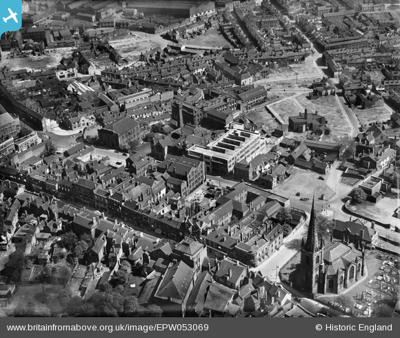
EPW053069 ENGLAND (1937). The High Street, King Street and environs, Dudley, 1937
© Copyright OpenStreetMap contributors and licensed by the OpenStreetMap Foundation. 2024. Cartography is licensed as CC BY-SA.
Nearby Images (15)
Details
| Title | [EPW053069] The High Street, King Street and environs, Dudley, 1937 |
| Reference | EPW053069 |
| Date | 18-May-1937 |
| Link | |
| Place name | DUDLEY |
| Parish | |
| District | |
| Country | ENGLAND |
| Easting / Northing | 394349, 290080 |
| Longitude / Latitude | -2.0832696324863, 52.508218297713 |
| National Grid Reference | SO943901 |
Pins
 black country history hunter |
Wednesday 9th of September 2015 01:54:01 AM |


![[EPW053069] The High Street, King Street and environs, Dudley, 1937](http://britainfromabove.org.uk/sites/all/libraries/aerofilms-images/public/100x100/EPW/053/EPW053069.jpg)
![[EPW053067] The Grainger and Smith Ltd Works on King Street and environs, Dudley, 1937](http://britainfromabove.org.uk/sites/all/libraries/aerofilms-images/public/100x100/EPW/053/EPW053067.jpg)
![[EPW053068] The Grainger and Smith Ltd Works on King Street and environs, Dudley, 1937](http://britainfromabove.org.uk/sites/all/libraries/aerofilms-images/public/100x100/EPW/053/EPW053068.jpg)
![[EPW053060] The High Street, the Grainger and Smith Ltd Works on King Street and environs, Dudley, 1937](http://britainfromabove.org.uk/sites/all/libraries/aerofilms-images/public/100x100/EPW/053/EPW053060.jpg)
![[EPW053062] King Street, the High Street and environs, Dudley, 1937](http://britainfromabove.org.uk/sites/all/libraries/aerofilms-images/public/100x100/EPW/053/EPW053062.jpg)
![[EPW053066] The Grainger and Smith Ltd Works on King Street and environs, Dudley, 1937](http://britainfromabove.org.uk/sites/all/libraries/aerofilms-images/public/100x100/EPW/053/EPW053066.jpg)
![[EPW053063] The Grainger and Smith Ltd Works on King Street and environs, Dudley, 1937](http://britainfromabove.org.uk/sites/all/libraries/aerofilms-images/public/100x100/EPW/053/EPW053063.jpg)
![[EPW053059] The Grainger and Smith Ltd Works on King Street and environs, Dudley, 1937](http://britainfromabove.org.uk/sites/all/libraries/aerofilms-images/public/100x100/EPW/053/EPW053059.jpg)
![[EPW053061] The Grainger and Smith Ltd Works on King Street and environs, Dudley, 1937](http://britainfromabove.org.uk/sites/all/libraries/aerofilms-images/public/100x100/EPW/053/EPW053061.jpg)
![[EPW053064] Garden Walk and environs, Dudley, 1937](http://britainfromabove.org.uk/sites/all/libraries/aerofilms-images/public/100x100/EPW/053/EPW053064.jpg)
![[EPW053065] Clothing Works on New Mill Street and environs, Dudley, 1937](http://britainfromabove.org.uk/sites/all/libraries/aerofilms-images/public/100x100/EPW/053/EPW053065.jpg)
![[EPW022587] St Thomas's Church and environs, Dudley, 1928](http://britainfromabove.org.uk/sites/all/libraries/aerofilms-images/public/100x100/EPW/022/EPW022587.jpg)
![[EPW053057] Clothing Works on New Mill Street, the Congregational Church on King Street and environs, Dudley, 1937](http://britainfromabove.org.uk/sites/all/libraries/aerofilms-images/public/100x100/EPW/053/EPW053057.jpg)
![[EPW053058] New Mill Street and environs, Dudley, 1937](http://britainfromabove.org.uk/sites/all/libraries/aerofilms-images/public/100x100/EPW/053/EPW053058.jpg)
![[EPW053075] The town centre, Dudley, 1937. This image has been produced from a copy-negative.](http://britainfromabove.org.uk/sites/all/libraries/aerofilms-images/public/100x100/EPW/053/EPW053075.jpg)