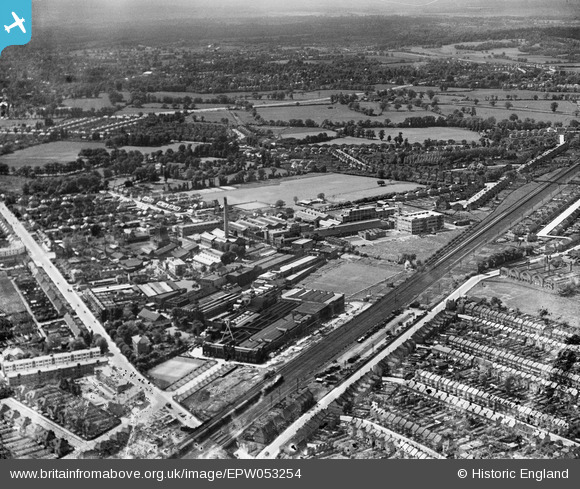
EPW053254 ENGLAND (1937). The Kodak Works and environs, Harrow, 1937
© Copyright OpenStreetMap contributors and licensed by the OpenStreetMap Foundation. 2024. Cartography is licensed as CC BY-SA.
Nearby Images (24)
Details
| Title | [EPW053254] The Kodak Works and environs, Harrow, 1937 |
| Reference | EPW053254 |
| Date | 27-May-1937 |
| Link | |
| Place name | HARROW |
| Parish | |
| District | |
| Country | ENGLAND |
| Easting / Northing | 514634, 189843 |
| Longitude / Latitude | -0.34485199327927, 51.595282052499 |
| National Grid Reference | TQ146898 |
Pins
 Sweet Pete |
Saturday 31st of January 2015 04:41:15 PM | |
 The Laird |
Tuesday 7th of January 2014 10:26:34 AM |


![[EPW053254] The Kodak Works and environs, Harrow, 1937](http://britainfromabove.org.uk/sites/all/libraries/aerofilms-images/public/100x100/EPW/053/EPW053254.jpg)
![[EPW053257] The Kodak Works, Harrow, 1937. This image has been produced from a damaged negative.](http://britainfromabove.org.uk/sites/all/libraries/aerofilms-images/public/100x100/EPW/053/EPW053257.jpg)
![[EPW053248] The Kodak Works and environs, Harrow, 1937](http://britainfromabove.org.uk/sites/all/libraries/aerofilms-images/public/100x100/EPW/053/EPW053248.jpg)
![[EPW053246] The Kodak Works and environs, Harrow, 1937](http://britainfromabove.org.uk/sites/all/libraries/aerofilms-images/public/100x100/EPW/053/EPW053246.jpg)
![[EPW053255] The Kodak Works and environs, Harrow, 1937](http://britainfromabove.org.uk/sites/all/libraries/aerofilms-images/public/100x100/EPW/053/EPW053255.jpg)
![[EPW053251] The Kodak Works and environs, Harrow, 1937](http://britainfromabove.org.uk/sites/all/libraries/aerofilms-images/public/100x100/EPW/053/EPW053251.jpg)
![[EPW053247] The Kodak Works and environs, Harrow, 1937](http://britainfromabove.org.uk/sites/all/libraries/aerofilms-images/public/100x100/EPW/053/EPW053247.jpg)
![[EAW035177] A Redex banner on tow over the Kodak Works, Harrow, from the north-east, 1951](http://britainfromabove.org.uk/sites/all/libraries/aerofilms-images/public/100x100/EAW/035/EAW035177.jpg)
![[EPW053245] The Kodak Works and environs, Harrow, 1937](http://britainfromabove.org.uk/sites/all/libraries/aerofilms-images/public/100x100/EPW/053/EPW053245.jpg)
![[EPW053249] The Kodak Works and environs, Harrow, 1937](http://britainfromabove.org.uk/sites/all/libraries/aerofilms-images/public/100x100/EPW/053/EPW053249.jpg)
![[EPW037281] The Kodak Works, Harrow, 1932](http://britainfromabove.org.uk/sites/all/libraries/aerofilms-images/public/100x100/EPW/037/EPW037281.jpg)
![[EPW062558] The Kodak Works and environs, Harrow, 1939](http://britainfromabove.org.uk/sites/all/libraries/aerofilms-images/public/100x100/EPW/062/EPW062558.jpg)
![[EPW037260] The Kodak Works and Printing Works (formerly David Allen and Sons), Harrow, 1932](http://britainfromabove.org.uk/sites/all/libraries/aerofilms-images/public/100x100/EPW/037/EPW037260.jpg)
![[EPW037265] The Kodak Works and environs, Harrow, 1932](http://britainfromabove.org.uk/sites/all/libraries/aerofilms-images/public/100x100/EPW/037/EPW037265.jpg)
![[EPW000475] David Allen and Sons Printing Works and the Kodak Works, Harrow, 1920](http://britainfromabove.org.uk/sites/all/libraries/aerofilms-images/public/100x100/EPW/000/EPW000475.jpg)
![[EPW062560] The Kodak Works and environs, Harrow, 1939](http://britainfromabove.org.uk/sites/all/libraries/aerofilms-images/public/100x100/EPW/062/EPW062560.jpg)
![[EPW062563] The Kodak Works and environs, Harrow, 1939. This image has been affected by flare.](http://britainfromabove.org.uk/sites/all/libraries/aerofilms-images/public/100x100/EPW/062/EPW062563.jpg)
![[EPW062568] The Kodak Works, Harrow, 1939](http://britainfromabove.org.uk/sites/all/libraries/aerofilms-images/public/100x100/EPW/062/EPW062568.jpg)
![[EPW000474] David Allen and Sons Printing Works and the Kodak Works, Harrow, 1920](http://britainfromabove.org.uk/sites/all/libraries/aerofilms-images/public/100x100/EPW/000/EPW000474.jpg)
![[EPW062750] The Kodak Works, Headstone Drive and environs, Harrow, 1939](http://britainfromabove.org.uk/sites/all/libraries/aerofilms-images/public/100x100/EPW/062/EPW062750.jpg)
![[EPW037264] The Kodak Works and environs, Harrow, 1932](http://britainfromabove.org.uk/sites/all/libraries/aerofilms-images/public/100x100/EPW/037/EPW037264.jpg)
![[EPW062751] The Kodak Works, Headstone Drive and environs, Harrow, 1939](http://britainfromabove.org.uk/sites/all/libraries/aerofilms-images/public/100x100/EPW/062/EPW062751.jpg)
![[EPW037266] The Kodak Works and environs, Harrow, 1932](http://britainfromabove.org.uk/sites/all/libraries/aerofilms-images/public/100x100/EPW/037/EPW037266.jpg)
![[EPW037280] The Kodak Works and environs, Harrow, 1932](http://britainfromabove.org.uk/sites/all/libraries/aerofilms-images/public/100x100/EPW/037/EPW037280.jpg)