© Copyright OpenStreetMap contributors and licensed by the OpenStreetMap Foundation. 2025. Cartography is licensed as CC BY-SA.
Details
| Title |
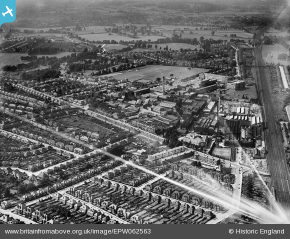
[EPW062563] The Kodak Works and environs, Harrow, 1939. This image has been affected by flare. |
| Reference |
EPW062563 |
| Date |
15-August-1939 |
| Link |
|
| Place name |
HARROW |
| Parish |
|
| District |
|
| Country |
ENGLAND |
| Easting / Northing |
514761, 189615 |
| Longitude / Latitude |
-0.34309371170021, 51.59320678838 |
| National Grid Reference |
TQ148896 |
Pins
 Site of Station Z - Air Ministry Citadel. This is quite an interesting view as it shows the building under construction.
It was planned in 1938, during the run-up to WW2, as an emergency HQ for the Air Ministry (RAF). In this it would serve the same purpose as the similar constructions built for the War Cabinet ('Paddock' - beneath the GPO Research Building at Dollis Hill) and the Oxgate Admiralty Citadel at Cricklewood. In the event of a devastating attack on London, the respective bodies would be able to relocate to these emergency facilities.
The Air Ministry Citadel was constructed on land at the rear of the HMSO building at Wealdstone and consisted of a three storey brick surface block surmounting heavily reinforced basement and sub-basement levels.
The block was demolished in the 90s after it had been acquired by Kodak. The protective underground levels survive.
The link below provides more detailed information.
http://www.subbrit.org.uk/sb-sites/sites/s/station_z/index1.shtml |

The Laird |
Wednesday 16th of September 2015 08:47:48 PM |


![[EPW062563] The Kodak Works and environs, Harrow, 1939. This image has been affected by flare.](http://britainfromabove.org.uk/sites/all/libraries/aerofilms-images/public/100x100/EPW/062/EPW062563.jpg)
![[EPW037265] The Kodak Works and environs, Harrow, 1932](http://britainfromabove.org.uk/sites/all/libraries/aerofilms-images/public/100x100/EPW/037/EPW037265.jpg)
![[EPW062558] The Kodak Works and environs, Harrow, 1939](http://britainfromabove.org.uk/sites/all/libraries/aerofilms-images/public/100x100/EPW/062/EPW062558.jpg)
![[EPW062750] The Kodak Works, Headstone Drive and environs, Harrow, 1939](http://britainfromabove.org.uk/sites/all/libraries/aerofilms-images/public/100x100/EPW/062/EPW062750.jpg)
![[EPW062560] The Kodak Works and environs, Harrow, 1939](http://britainfromabove.org.uk/sites/all/libraries/aerofilms-images/public/100x100/EPW/062/EPW062560.jpg)
![[EPW062561] The Kodak Works and environs, Harrow, 1939](http://britainfromabove.org.uk/sites/all/libraries/aerofilms-images/public/100x100/EPW/062/EPW062561.jpg)
![[EPW037280] The Kodak Works and environs, Harrow, 1932](http://britainfromabove.org.uk/sites/all/libraries/aerofilms-images/public/100x100/EPW/037/EPW037280.jpg)
![[EPW062753] The Kodak Works, Headstone Drive and environs, Harrow, 1939](http://britainfromabove.org.uk/sites/all/libraries/aerofilms-images/public/100x100/EPW/062/EPW062753.jpg)
![[EPW037266] The Kodak Works and environs, Harrow, 1932](http://britainfromabove.org.uk/sites/all/libraries/aerofilms-images/public/100x100/EPW/037/EPW037266.jpg)
![[EPW053249] The Kodak Works and environs, Harrow, 1937](http://britainfromabove.org.uk/sites/all/libraries/aerofilms-images/public/100x100/EPW/053/EPW053249.jpg)
![[EPW037281] The Kodak Works, Harrow, 1932](http://britainfromabove.org.uk/sites/all/libraries/aerofilms-images/public/100x100/EPW/037/EPW037281.jpg)
![[EPW062751] The Kodak Works, Headstone Drive and environs, Harrow, 1939](http://britainfromabove.org.uk/sites/all/libraries/aerofilms-images/public/100x100/EPW/062/EPW062751.jpg)
![[EPW053245] The Kodak Works and environs, Harrow, 1937](http://britainfromabove.org.uk/sites/all/libraries/aerofilms-images/public/100x100/EPW/053/EPW053245.jpg)
![[EPW037264] The Kodak Works and environs, Harrow, 1932](http://britainfromabove.org.uk/sites/all/libraries/aerofilms-images/public/100x100/EPW/037/EPW037264.jpg)
![[EPW062568] The Kodak Works, Harrow, 1939](http://britainfromabove.org.uk/sites/all/libraries/aerofilms-images/public/100x100/EPW/062/EPW062568.jpg)
![[EPW053247] The Kodak Works and environs, Harrow, 1937](http://britainfromabove.org.uk/sites/all/libraries/aerofilms-images/public/100x100/EPW/053/EPW053247.jpg)
![[EPW062565] The Kodak Works and environs, Harrow, 1939](http://britainfromabove.org.uk/sites/all/libraries/aerofilms-images/public/100x100/EPW/062/EPW062565.jpg)
![[EPW053255] The Kodak Works and environs, Harrow, 1937](http://britainfromabove.org.uk/sites/all/libraries/aerofilms-images/public/100x100/EPW/053/EPW053255.jpg)
![[EPW000475] David Allen and Sons Printing Works and the Kodak Works, Harrow, 1920](http://britainfromabove.org.uk/sites/all/libraries/aerofilms-images/public/100x100/EPW/000/EPW000475.jpg)
![[EPW000474] David Allen and Sons Printing Works and the Kodak Works, Harrow, 1920](http://britainfromabove.org.uk/sites/all/libraries/aerofilms-images/public/100x100/EPW/000/EPW000474.jpg)
![[EPW053251] The Kodak Works and environs, Harrow, 1937](http://britainfromabove.org.uk/sites/all/libraries/aerofilms-images/public/100x100/EPW/053/EPW053251.jpg)
![[EPW037260] The Kodak Works and Printing Works (formerly David Allen and Sons), Harrow, 1932](http://britainfromabove.org.uk/sites/all/libraries/aerofilms-images/public/100x100/EPW/037/EPW037260.jpg)
![[EPW037261] The Kodak Works and Printing Works (formerly David Allen and Sons), Harrow, 1932](http://britainfromabove.org.uk/sites/all/libraries/aerofilms-images/public/100x100/EPW/037/EPW037261.jpg)
![[EPW037262] The Kodak Works and Printing Works (formerly David Allen and Sons), Harrow, 1932](http://britainfromabove.org.uk/sites/all/libraries/aerofilms-images/public/100x100/EPW/037/EPW037262.jpg)
![[EPW037263] The Kodak Works and Printing Works (formerly David Allen and Sons), Harrow, 1932](http://britainfromabove.org.uk/sites/all/libraries/aerofilms-images/public/100x100/EPW/037/EPW037263.jpg)
![[EPW062752] The Kodak Works and environs, Harrow, 1939](http://britainfromabove.org.uk/sites/all/libraries/aerofilms-images/public/100x100/EPW/062/EPW062752.jpg)
![[EPW037259] The Kodak Works and Printing Works (formerly David Allen and Sons), Harrow, 1932](http://britainfromabove.org.uk/sites/all/libraries/aerofilms-images/public/100x100/EPW/037/EPW037259.jpg)
![[EPW053246] The Kodak Works and environs, Harrow, 1937](http://britainfromabove.org.uk/sites/all/libraries/aerofilms-images/public/100x100/EPW/053/EPW053246.jpg)
![[EPW062567] The Kodak Works and environs, Harrow, from the south, 1939](http://britainfromabove.org.uk/sites/all/libraries/aerofilms-images/public/100x100/EPW/062/EPW062567.jpg)
![[EPW053257] The Kodak Works, Harrow, 1937. This image has been produced from a damaged negative.](http://britainfromabove.org.uk/sites/all/libraries/aerofilms-images/public/100x100/EPW/053/EPW053257.jpg)
![[EPW053248] The Kodak Works and environs, Harrow, 1937](http://britainfromabove.org.uk/sites/all/libraries/aerofilms-images/public/100x100/EPW/053/EPW053248.jpg)
![[EAW035177] A Redex banner on tow over the Kodak Works, Harrow, from the north-east, 1951](http://britainfromabove.org.uk/sites/all/libraries/aerofilms-images/public/100x100/EAW/035/EAW035177.jpg)
![[EPW062559] The Kodak Works and environs, Harrow, from the south-west, 1939](http://britainfromabove.org.uk/sites/all/libraries/aerofilms-images/public/100x100/EPW/062/EPW062559.jpg)
![[EPW053254] The Kodak Works and environs, Harrow, 1937](http://britainfromabove.org.uk/sites/all/libraries/aerofilms-images/public/100x100/EPW/053/EPW053254.jpg)