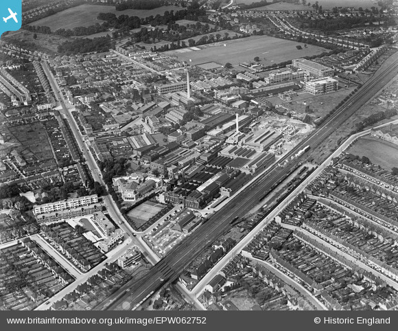
EPW062752 ENGLAND (1939). The Kodak Works and environs, Harrow, 1939
© Copyright OpenStreetMap contributors and licensed by the OpenStreetMap Foundation. 2024. Cartography is licensed as CC BY-SA.
Nearby Images (25)
Details
| Title | [EPW062752] The Kodak Works and environs, Harrow, 1939 |
| Reference | EPW062752 |
| Date | 23-August-1939 |
| Link | |
| Place name | HARROW |
| Parish | |
| District | |
| Country | ENGLAND |
| Easting / Northing | 514933, 189697 |
| Longitude / Latitude | -0.34058465095874, 51.593908781675 |
| National Grid Reference | TQ149897 |
Pins
 The Laird |
Saturday 2nd of July 2016 06:59:23 PM |


![[EPW062752] The Kodak Works and environs, Harrow, 1939](http://britainfromabove.org.uk/sites/all/libraries/aerofilms-images/public/100x100/EPW/062/EPW062752.jpg)
![[EPW037262] The Kodak Works and Printing Works (formerly David Allen and Sons), Harrow, 1932](http://britainfromabove.org.uk/sites/all/libraries/aerofilms-images/public/100x100/EPW/037/EPW037262.jpg)
![[EPW037261] The Kodak Works and Printing Works (formerly David Allen and Sons), Harrow, 1932](http://britainfromabove.org.uk/sites/all/libraries/aerofilms-images/public/100x100/EPW/037/EPW037261.jpg)
![[EPW037263] The Kodak Works and Printing Works (formerly David Allen and Sons), Harrow, 1932](http://britainfromabove.org.uk/sites/all/libraries/aerofilms-images/public/100x100/EPW/037/EPW037263.jpg)
![[EPW037259] The Kodak Works and Printing Works (formerly David Allen and Sons), Harrow, 1932](http://britainfromabove.org.uk/sites/all/libraries/aerofilms-images/public/100x100/EPW/037/EPW037259.jpg)
![[EPW037264] The Kodak Works and environs, Harrow, 1932](http://britainfromabove.org.uk/sites/all/libraries/aerofilms-images/public/100x100/EPW/037/EPW037264.jpg)
![[EPW000474] David Allen and Sons Printing Works and the Kodak Works, Harrow, 1920](http://britainfromabove.org.uk/sites/all/libraries/aerofilms-images/public/100x100/EPW/000/EPW000474.jpg)
![[EPW062565] The Kodak Works and environs, Harrow, 1939](http://britainfromabove.org.uk/sites/all/libraries/aerofilms-images/public/100x100/EPW/062/EPW062565.jpg)
![[EPW062568] The Kodak Works, Harrow, 1939](http://britainfromabove.org.uk/sites/all/libraries/aerofilms-images/public/100x100/EPW/062/EPW062568.jpg)
![[EPW000475] David Allen and Sons Printing Works and the Kodak Works, Harrow, 1920](http://britainfromabove.org.uk/sites/all/libraries/aerofilms-images/public/100x100/EPW/000/EPW000475.jpg)
![[EPW037260] The Kodak Works and Printing Works (formerly David Allen and Sons), Harrow, 1932](http://britainfromabove.org.uk/sites/all/libraries/aerofilms-images/public/100x100/EPW/037/EPW037260.jpg)
![[EPW062751] The Kodak Works, Headstone Drive and environs, Harrow, 1939](http://britainfromabove.org.uk/sites/all/libraries/aerofilms-images/public/100x100/EPW/062/EPW062751.jpg)
![[EPW037266] The Kodak Works and environs, Harrow, 1932](http://britainfromabove.org.uk/sites/all/libraries/aerofilms-images/public/100x100/EPW/037/EPW037266.jpg)
![[EPW062560] The Kodak Works and environs, Harrow, 1939](http://britainfromabove.org.uk/sites/all/libraries/aerofilms-images/public/100x100/EPW/062/EPW062560.jpg)
![[EPW037280] The Kodak Works and environs, Harrow, 1932](http://britainfromabove.org.uk/sites/all/libraries/aerofilms-images/public/100x100/EPW/037/EPW037280.jpg)
![[EPW062753] The Kodak Works, Headstone Drive and environs, Harrow, 1939](http://britainfromabove.org.uk/sites/all/libraries/aerofilms-images/public/100x100/EPW/062/EPW062753.jpg)
![[EPW062750] The Kodak Works, Headstone Drive and environs, Harrow, 1939](http://britainfromabove.org.uk/sites/all/libraries/aerofilms-images/public/100x100/EPW/062/EPW062750.jpg)
![[EPW062558] The Kodak Works and environs, Harrow, 1939](http://britainfromabove.org.uk/sites/all/libraries/aerofilms-images/public/100x100/EPW/062/EPW062558.jpg)
![[EPW037281] The Kodak Works, Harrow, 1932](http://britainfromabove.org.uk/sites/all/libraries/aerofilms-images/public/100x100/EPW/037/EPW037281.jpg)
![[EPW037265] The Kodak Works and environs, Harrow, 1932](http://britainfromabove.org.uk/sites/all/libraries/aerofilms-images/public/100x100/EPW/037/EPW037265.jpg)
![[EPW062561] The Kodak Works and environs, Harrow, 1939](http://britainfromabove.org.uk/sites/all/libraries/aerofilms-images/public/100x100/EPW/062/EPW062561.jpg)
![[EPW062563] The Kodak Works and environs, Harrow, 1939. This image has been affected by flare.](http://britainfromabove.org.uk/sites/all/libraries/aerofilms-images/public/100x100/EPW/062/EPW062563.jpg)
![[EPW053249] The Kodak Works and environs, Harrow, 1937](http://britainfromabove.org.uk/sites/all/libraries/aerofilms-images/public/100x100/EPW/053/EPW053249.jpg)
![[EPW053247] The Kodak Works and environs, Harrow, 1937](http://britainfromabove.org.uk/sites/all/libraries/aerofilms-images/public/100x100/EPW/053/EPW053247.jpg)
![[EPW062566] The Kodak Works and environs, Harrow, from the east, 1939](http://britainfromabove.org.uk/sites/all/libraries/aerofilms-images/public/100x100/EPW/062/EPW062566.jpg)