
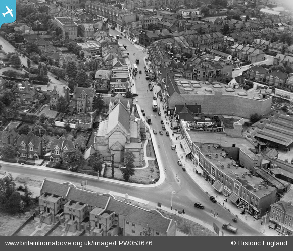
EPW053676 ENGLAND (1937). St John the Baptist's Church and Station Road, Harrow, 1937
© Copyright OpenStreetMap contributors and licensed by the OpenStreetMap Foundation. 2025. Cartography is licensed as CC BY-SA.
Nearby Images (7)
EPW053676

EPW000472

EPW053682

EPW053690

EPW053683

EPW000473

EPW053688

Details
| Title | [EPW053676] St John the Baptist's Church and Station Road, Harrow, 1937 |
| Reference | EPW053676 |
| Date | 12-June-1937 |
| Link | |
| Place name | HARROW |
| Parish | |
| District | |
| Country | ENGLAND |
| Easting / Northing | 515639, 188362 |
| Longitude / Latitude | -0.33083590077935, 51.581764557466 |
| National Grid Reference | TQ156884 |
Pins
 The Laird |
Sunday 12th of January 2020 01:10:53 PM | |
 amazos |
Friday 15th of March 2019 06:47:58 PM | |
The Laird |
Wednesday 28th of March 2018 07:59:36 PM | |
The Laird |
Wednesday 28th of March 2018 05:10:10 PM | |
The Laird |
Monday 27th of April 2015 01:55:12 PM | |
Sweet Pete |
Monday 16th of March 2015 04:40:20 PM | |
The building must have gone through several changes of use in its life. I have a friend whose father ran a plastic recycling business there in the 1970s and 80s. He said that it was at one time a dairy (very close to the United Dairies place, so perhaps the stables for the rounds horses). It all went some years ago and public conveniences were built there. These too have already now gone. |
The Laird |
Saturday 3rd of March 2018 12:14:36 AM |
Sweet Pete |
Monday 16th of March 2015 04:36:59 PM | |
I believe that the old Havelock building is a smaller building to the right of your marker nearer St Ann's Road and on the other side of the Harrow Observer building. The building you have indicated is the North Thames Gas showroom. The original Havelock pub was a small old fashioned pub that was demolished and rebuilt in about 1960. |
The Laird |
Monday 27th of April 2015 01:53:41 PM |
I take the Lairds comment, I'm inclined to agree with him here. |
Sweet Pete |
Monday 20th of July 2015 05:49:35 PM |
Sweet Pete |
Friday 23rd of January 2015 04:59:55 PM | |
Coventry kid |
Saturday 12th of April 2014 08:52:35 PM | |
Quite right, it was LLoyd's Bank. |
Sweet Pete |
Monday 16th of March 2015 04:38:16 PM |
Yes, I agree, Lloyds Bank was on this corner. My mother worked there in the seventies. |
amazos |
Friday 29th of January 2016 11:14:45 PM |
simes188 |
Sunday 24th of November 2013 10:10:04 PM | |
Yes this is the Natwest Bank but at the time the photo was taken this was the Provincial Bank. |
Sweet Pete |
Friday 23rd of January 2015 05:03:01 PM |
 Maurice |
Friday 23rd of August 2013 06:38:49 AM | |
I don't know, but the Union Jack on The Popular Stores (Co-Op) in High Street Wealdstone was flying that day too. Sure that would not be common in middle of the war. |
JamesMac |
Sunday 10th of November 2013 09:45:34 PM |
Spanish Civil War? |
czyrko |
Saturday 26th of April 2014 06:01:24 PM |
I grew up in Harrow in the 1950's and I believe this building was the register office so it might have been a wedding! |
Sweet Pete |
Saturday 31st of January 2015 05:23:59 PM |
I think that this was actually the Gayton Rooms. These were function rooms and hall run by Wright Coopers, Bakers & Confectioners. It was at one time the main function venue in this part of Harrow and did good business. It also hosted local masonic lodge meetings - probably before the masonic centre in Northwick Circle was inaugurated in the early fifties. It can be seen that the building at the rear towards Greenhill Crescent was quite extensive. The building was demolished in about 1967 and replaced by a new building housing Universal Stationers. I believe that Superdrug now occupy this building. |
The Laird |
Sunday 12th of January 2020 12:49:27 PM |
JamesMac |
Friday 23rd of August 2013 05:45:57 AM | |
JamesMac |
Friday 23rd of August 2013 05:42:36 AM | |
JamesMac |
Friday 23rd of August 2013 05:41:52 AM | |
JamesMac |
Friday 23rd of August 2013 05:41:21 AM | |
JamesMac |
Friday 23rd of August 2013 05:40:22 AM | |
JamesMac |
Friday 23rd of August 2013 05:39:38 AM | |
JamesMac |
Friday 23rd of August 2013 05:39:08 AM | |
What lovely big houses there were in St John's Road, Lyon Road and Gayton Road at this time. Starting from about 1960 on, Harrow began to go mad and proceeded to tear them down and replace them with stark office blocks and blocks of flats. Several of these were council offices! I remember that one of these revoltingly ugly blocks in Lyon Road was occupied by the National Coal Board...in Harrow! |
The Laird |
Wednesday 28th of March 2018 04:30:38 PM |
JamesMac |
Friday 23rd of August 2013 04:56:16 AM | |
JamesMac |
Friday 23rd of August 2013 04:50:48 AM | |
JamesMac |
Friday 23rd of August 2013 04:49:04 AM | |
This was a chain of chinaware shops. |
The Laird |
Wednesday 6th of May 2015 11:06:44 AM |
JamesMac |
Friday 23rd of August 2013 04:46:18 AM | |
JamesMac |
Friday 23rd of August 2013 04:44:18 AM | |
JamesMac |
Friday 23rd of August 2013 04:43:56 AM | |
JamesMac |
Friday 23rd of August 2013 04:43:21 AM | |
The Laird |
Wednesday 14th of August 2013 06:05:22 PM | |
The Laird |
Wednesday 14th of August 2013 06:00:45 PM | |
kels |
Monday 12th of August 2013 04:17:35 PM |