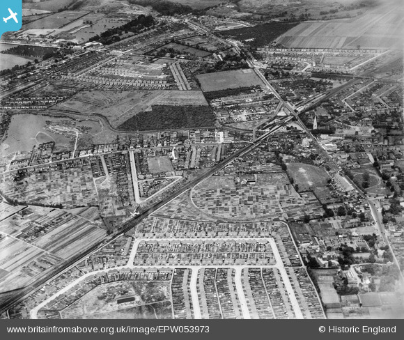
EPW053973 ENGLAND (1937). The town, Feltham, 1937
© Copyright OpenStreetMap contributors and licensed by the OpenStreetMap Foundation. 2025. Cartography is licensed as CC BY-SA.
Details
| Title | [EPW053973] The town, Feltham, 1937 |
| Reference | EPW053973 |
| Date | June-1937 |
| Link | |
| Place name | FELTHAM |
| Parish | |
| District | |
| Country | ENGLAND |
| Easting / Northing | 510340, 173261 |
| Longitude / Latitude | -0.41201872700803, 51.447084002344 |
| National Grid Reference | TQ103733 |
Pins
 The Laird |
Wednesday 9th of February 2022 01:47:30 AM | |
 Bdog507 |
Monday 12th of July 2021 03:39:54 PM | |
 waylou |
Wednesday 21st of April 2021 06:16:56 PM | |
 waylou |
Wednesday 21st of April 2021 06:15:47 PM | |
 Bdog507 |
Monday 26th of February 2018 03:08:47 PM | |
 Brian |
Sunday 15th of February 2015 07:44:50 PM | |
 Captain MC |
Thursday 5th of December 2013 10:15:18 PM | |
 Captain MC |
Thursday 5th of December 2013 10:12:09 PM |


![[EPW053973] The town, Feltham, 1937](http://britainfromabove.org.uk/sites/all/libraries/aerofilms-images/public/100x100/EPW/053/EPW053973.jpg)
![[EPW053968] High Street and environs, Feltham, 1937. This image has been produced from a copy-negative.](http://britainfromabove.org.uk/sites/all/libraries/aerofilms-images/public/100x100/EPW/053/EPW053968.jpg)
![[EPW053970] The town, Feltham, 1937](http://britainfromabove.org.uk/sites/all/libraries/aerofilms-images/public/100x100/EPW/053/EPW053970.jpg)
