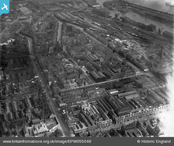
EPW055048 ENGLAND (1937). Edgar Street and environs, Kingston upon Hull, 1937. This image has been produced from a print affected by flare.
© Copyright OpenStreetMap contributors and licensed by the OpenStreetMap Foundation. 2025. Cartography is licensed as CC BY-SA.
Nearby Images (29)
Details
| Title | [EPW055048] Edgar Street and environs, Kingston upon Hull, 1937. This image has been produced from a print affected by flare. |
| Reference | EPW055048 |
| Date | August-1937 |
| Link | |
| Place name | KINGSTON UPON HULL |
| Parish | |
| District | |
| Country | ENGLAND |
| Easting / Northing | 508802, 427991 |
| Longitude / Latitude | -0.35031928880063, 53.736716755706 |
| National Grid Reference | TA088280 |
Pins
 bill@kinetic.karoo.co.uk |
Friday 16th of December 2016 11:46:58 AM | |
 John Wass |
Friday 3rd of April 2015 09:39:40 PM | |
 CartoonHead |
Sunday 23rd of November 2014 08:11:46 PM | |
 CartoonHead |
Sunday 23rd of November 2014 08:06:52 PM |


![[EPW055048] Edgar Street and environs, Kingston upon Hull, 1937. This image has been produced from a print affected by flare.](http://britainfromabove.org.uk/sites/all/libraries/aerofilms-images/public/100x100/EPW/055/EPW055048.jpg)
![[EAW035535] The Smith and Nephew Associated Companies Ltd Factory under construction off Neptune Street and environs, Kingston upon Hull, 1951. This image has been produced from a print marked by Aerofilms Ltd for photo editing.](http://britainfromabove.org.uk/sites/all/libraries/aerofilms-images/public/100x100/EAW/035/EAW035535.jpg)
![[EAW031240] Construction underway at the Smith and Nephew Ltd Paragon Works site, Kingston upon Hull, 1950](http://britainfromabove.org.uk/sites/all/libraries/aerofilms-images/public/100x100/EAW/031/EAW031240.jpg)
![[EAW043298] The Smith and Nephew Associated Companies Ltd Factory on Neptune Street and environs, Kingston upon Hull, 1952. This image was marked by Aerofilms Ltd for photo editing.](http://britainfromabove.org.uk/sites/all/libraries/aerofilms-images/public/100x100/EAW/043/EAW043298.jpg)
![[EAW035534] The Smith and Nephew Associated Companies Ltd Factory under construction off Neptune Street, Kingston upon Hull, 1951. This image has been produced from a print marked by Aerofilms Ltd for photo editing.](http://britainfromabove.org.uk/sites/all/libraries/aerofilms-images/public/100x100/EAW/035/EAW035534.jpg)
![[EAW031236] The Smith and Nephew Ltd Paragon Works and environs, Kingston upon Hull, 1950. This image was marked by Aerofilms Ltd for photo editing.](http://britainfromabove.org.uk/sites/all/libraries/aerofilms-images/public/100x100/EAW/031/EAW031236.jpg)
![[EAW035536] The Smith and Nephew Associated Companies Ltd Factory under construction off Neptune Street, Kingston upon Hull, 1951. This image has been produced from a print marked by Aerofilms Ltd for photo editing.](http://britainfromabove.org.uk/sites/all/libraries/aerofilms-images/public/100x100/EAW/035/EAW035536.jpg)
![[EAW035532] The Smith and Nephew Associated Companies Ltd Factory under construction off Neptune Street, Kingston upon Hull, 1951. This image has been produced from a print marked by Aerofilms Ltd for photo editing.](http://britainfromabove.org.uk/sites/all/libraries/aerofilms-images/public/100x100/EAW/035/EAW035532.jpg)
![[EAW031233] Construction underway at the Smith and Nephew Ltd Paragon Works site, Kingston upon Hull, 1950. This image was marked by Aerofilms Ltd for photo editing.](http://britainfromabove.org.uk/sites/all/libraries/aerofilms-images/public/100x100/EAW/031/EAW031233.jpg)
![[EAW043293] The Smith and Nephew Associated Companies Ltd Factory on Neptune Street, Kingston upon Hull, 1952. This image was marked by Aerofilms Ltd for photo editing.](http://britainfromabove.org.uk/sites/all/libraries/aerofilms-images/public/100x100/EAW/043/EAW043293.jpg)
![[EAW031235] Construction underway at the Smith and Nephew Ltd Paragon Works site, Kingston upon Hull, 1950. This image was marked by Aerofilms Ltd for photo editing.](http://britainfromabove.org.uk/sites/all/libraries/aerofilms-images/public/100x100/EAW/031/EAW031235.jpg)
![[EAW031241] Construction underway at the Smith and Nephew Ltd Paragon Works site, Kingston upon Hull, 1950](http://britainfromabove.org.uk/sites/all/libraries/aerofilms-images/public/100x100/EAW/031/EAW031241.jpg)
![[EAW035531] The Smith and Nephew Associated Companies Ltd Factory under construction off Neptune Street, Kingston upon Hull, 1951. This image has been produced from a print marked by Aerofilms Ltd for photo editing.](http://britainfromabove.org.uk/sites/all/libraries/aerofilms-images/public/100x100/EAW/035/EAW035531.jpg)
![[EAW031239] Construction underway at the Smith and Nephew Ltd Paragon Works site, Kingston upon Hull, 1950. This image was marked by Aerofilms Ltd for photo editing.](http://britainfromabove.org.uk/sites/all/libraries/aerofilms-images/public/100x100/EAW/031/EAW031239.jpg)
![[EAW031234] Construction underway at the Smith and Nephew Ltd Paragon Works site, Kingston upon Hull, 1950. This image was marked by Aerofilms Ltd for photo editing.](http://britainfromabove.org.uk/sites/all/libraries/aerofilms-images/public/100x100/EAW/031/EAW031234.jpg)
![[EAW035530] The Smith and Nephew Associated Companies Ltd Factory under construction off Neptune Street, Kingston upon Hull, 1951. This image has been produced from a print marked by Aerofilms Ltd for photo editing.](http://britainfromabove.org.uk/sites/all/libraries/aerofilms-images/public/100x100/EAW/035/EAW035530.jpg)
![[EAW031237] The Smith and Nephew Ltd Paragon Works and environs, Kingston upon Hull, 1950. This image was marked by Aerofilms Ltd for photo editing.](http://britainfromabove.org.uk/sites/all/libraries/aerofilms-images/public/100x100/EAW/031/EAW031237.jpg)
![[EAW043300] The Smith and Nephew Associated Companies Ltd Factory on Neptune Street and environs, Kingston upon Hull, 1952. This image was marked by Aerofilms Ltd for photo editing.](http://britainfromabove.org.uk/sites/all/libraries/aerofilms-images/public/100x100/EAW/043/EAW043300.jpg)
![[EAW031238] The Smith and Nephew Ltd Paragon Works and environs, Kingston upon Hull, 1950. This image was marked by Aerofilms Ltd for photo editing.](http://britainfromabove.org.uk/sites/all/libraries/aerofilms-images/public/100x100/EAW/031/EAW031238.jpg)
![[EAW035528] The Smith and Nephew Associated Companies Ltd Factory under construction off Neptune Street, Kingston upon Hull, 1951. This image has been produced from a print marked by Aerofilms Ltd for photo editing.](http://britainfromabove.org.uk/sites/all/libraries/aerofilms-images/public/100x100/EAW/035/EAW035528.jpg)
![[EAW043299] The Smith and Nephew Associated Companies Ltd Factory on Neptune Street and environs, Kingston upon Hull, 1952. This image was marked by Aerofilms Ltd for photo editing.](http://britainfromabove.org.uk/sites/all/libraries/aerofilms-images/public/100x100/EAW/043/EAW043299.jpg)
![[EAW043297] The Smith and Nephew Associated Companies Ltd Factory on Neptune Street looking towards the River Humber, Kingston upon Hull, 1952. This image was marked by Aerofilms Ltd for photo editing.](http://britainfromabove.org.uk/sites/all/libraries/aerofilms-images/public/100x100/EAW/043/EAW043297.jpg)
![[EPW009398] The Albert Docks and environs, Kingston upon Hull, 1923](http://britainfromabove.org.uk/sites/all/libraries/aerofilms-images/public/100x100/EPW/009/EPW009398.jpg)
![[EAW043296] Hessle Road and the Smith and Nephew Associated Companies Ltd Factory on Neptune Street, Kingston upon Hull, 1952. This image was marked by Aerofilms Ltd for photo editing.](http://britainfromabove.org.uk/sites/all/libraries/aerofilms-images/public/100x100/EAW/043/EAW043296.jpg)
![[EAW004513] The docks, Kingston upon Hull, from the west, 1947](http://britainfromabove.org.uk/sites/all/libraries/aerofilms-images/public/100x100/EAW/004/EAW004513.jpg)
![[EAW043294] Neptune Street Goods Station and the Smith and Nephew Associated Companies Ltd Factory on Neptune Street, Kingston upon Hull, 1952. This image was marked by Aerofilms Ltd for photo editing.](http://britainfromabove.org.uk/sites/all/libraries/aerofilms-images/public/100x100/EAW/043/EAW043294.jpg)
![[EAW035529] The Smith and Nephew Associated Companies Ltd Factory under construction off Neptune Street, Kingston upon Hull, 1951. This image has been produced from a print marked by Aerofilms Ltd for photo editing.](http://britainfromabove.org.uk/sites/all/libraries/aerofilms-images/public/100x100/EAW/035/EAW035529.jpg)
![[EAW035533] The Smith and Nephew Associated Companies Ltd Factory under construction off Neptune Street, Kingston upon Hull, 1951. This image has been produced from a print marked by Aerofilms Ltd for photo editing.](http://britainfromabove.org.uk/sites/all/libraries/aerofilms-images/public/100x100/EAW/035/EAW035533.jpg)
![[EPW009399] The Albert Docks and Neptune Street Goods Station, Kingston upon Hull, 1923](http://britainfromabove.org.uk/sites/all/libraries/aerofilms-images/public/100x100/EPW/009/EPW009399.jpg)