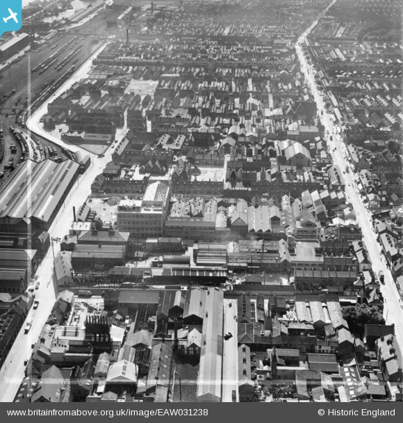
EAW031238 ENGLAND (1950). The Smith and Nephew Ltd Paragon Works and environs, Kingston upon Hull, 1950. This image was marked by Aerofilms Ltd for photo editing.
© Copyright OpenStreetMap contributors and licensed by the OpenStreetMap Foundation. 2025. Cartography is licensed as CC BY-SA.
Nearby Images (30)
Details
| Title | [EAW031238] The Smith and Nephew Ltd Paragon Works and environs, Kingston upon Hull, 1950. This image was marked by Aerofilms Ltd for photo editing. |
| Reference | EAW031238 |
| Date | 25-July-1950 |
| Link | |
| Place name | KINGSTON UPON HULL |
| Parish | |
| District | |
| Country | ENGLAND |
| Easting / Northing | 508607, 427896 |
| Longitude / Latitude | -0.35330795126433, 53.73590379546 |
| National Grid Reference | TA086279 |
Pins
Be the first to add a comment to this image!


![[EAW031238] The Smith and Nephew Ltd Paragon Works and environs, Kingston upon Hull, 1950. This image was marked by Aerofilms Ltd for photo editing.](http://britainfromabove.org.uk/sites/all/libraries/aerofilms-images/public/100x100/EAW/031/EAW031238.jpg)
![[EAW035528] The Smith and Nephew Associated Companies Ltd Factory under construction off Neptune Street, Kingston upon Hull, 1951. This image has been produced from a print marked by Aerofilms Ltd for photo editing.](http://britainfromabove.org.uk/sites/all/libraries/aerofilms-images/public/100x100/EAW/035/EAW035528.jpg)
![[EAW043299] The Smith and Nephew Associated Companies Ltd Factory on Neptune Street and environs, Kingston upon Hull, 1952. This image was marked by Aerofilms Ltd for photo editing.](http://britainfromabove.org.uk/sites/all/libraries/aerofilms-images/public/100x100/EAW/043/EAW043299.jpg)
![[EAW031237] The Smith and Nephew Ltd Paragon Works and environs, Kingston upon Hull, 1950. This image was marked by Aerofilms Ltd for photo editing.](http://britainfromabove.org.uk/sites/all/libraries/aerofilms-images/public/100x100/EAW/031/EAW031237.jpg)
![[EAW043296] Hessle Road and the Smith and Nephew Associated Companies Ltd Factory on Neptune Street, Kingston upon Hull, 1952. This image was marked by Aerofilms Ltd for photo editing.](http://britainfromabove.org.uk/sites/all/libraries/aerofilms-images/public/100x100/EAW/043/EAW043296.jpg)
![[EAW031239] Construction underway at the Smith and Nephew Ltd Paragon Works site, Kingston upon Hull, 1950. This image was marked by Aerofilms Ltd for photo editing.](http://britainfromabove.org.uk/sites/all/libraries/aerofilms-images/public/100x100/EAW/031/EAW031239.jpg)
![[EAW035529] The Smith and Nephew Associated Companies Ltd Factory under construction off Neptune Street, Kingston upon Hull, 1951. This image has been produced from a print marked by Aerofilms Ltd for photo editing.](http://britainfromabove.org.uk/sites/all/libraries/aerofilms-images/public/100x100/EAW/035/EAW035529.jpg)
![[EAW035533] The Smith and Nephew Associated Companies Ltd Factory under construction off Neptune Street, Kingston upon Hull, 1951. This image has been produced from a print marked by Aerofilms Ltd for photo editing.](http://britainfromabove.org.uk/sites/all/libraries/aerofilms-images/public/100x100/EAW/035/EAW035533.jpg)
![[EAW031234] Construction underway at the Smith and Nephew Ltd Paragon Works site, Kingston upon Hull, 1950. This image was marked by Aerofilms Ltd for photo editing.](http://britainfromabove.org.uk/sites/all/libraries/aerofilms-images/public/100x100/EAW/031/EAW031234.jpg)
![[EAW043300] The Smith and Nephew Associated Companies Ltd Factory on Neptune Street and environs, Kingston upon Hull, 1952. This image was marked by Aerofilms Ltd for photo editing.](http://britainfromabove.org.uk/sites/all/libraries/aerofilms-images/public/100x100/EAW/043/EAW043300.jpg)
![[EAW035532] The Smith and Nephew Associated Companies Ltd Factory under construction off Neptune Street, Kingston upon Hull, 1951. This image has been produced from a print marked by Aerofilms Ltd for photo editing.](http://britainfromabove.org.uk/sites/all/libraries/aerofilms-images/public/100x100/EAW/035/EAW035532.jpg)
![[EAW035531] The Smith and Nephew Associated Companies Ltd Factory under construction off Neptune Street, Kingston upon Hull, 1951. This image has been produced from a print marked by Aerofilms Ltd for photo editing.](http://britainfromabove.org.uk/sites/all/libraries/aerofilms-images/public/100x100/EAW/035/EAW035531.jpg)
![[EAW035536] The Smith and Nephew Associated Companies Ltd Factory under construction off Neptune Street, Kingston upon Hull, 1951. This image has been produced from a print marked by Aerofilms Ltd for photo editing.](http://britainfromabove.org.uk/sites/all/libraries/aerofilms-images/public/100x100/EAW/035/EAW035536.jpg)
![[EAW031236] The Smith and Nephew Ltd Paragon Works and environs, Kingston upon Hull, 1950. This image was marked by Aerofilms Ltd for photo editing.](http://britainfromabove.org.uk/sites/all/libraries/aerofilms-images/public/100x100/EAW/031/EAW031236.jpg)
![[EAW043297] The Smith and Nephew Associated Companies Ltd Factory on Neptune Street looking towards the River Humber, Kingston upon Hull, 1952. This image was marked by Aerofilms Ltd for photo editing.](http://britainfromabove.org.uk/sites/all/libraries/aerofilms-images/public/100x100/EAW/043/EAW043297.jpg)
![[EAW031241] Construction underway at the Smith and Nephew Ltd Paragon Works site, Kingston upon Hull, 1950](http://britainfromabove.org.uk/sites/all/libraries/aerofilms-images/public/100x100/EAW/031/EAW031241.jpg)
![[EAW035534] The Smith and Nephew Associated Companies Ltd Factory under construction off Neptune Street, Kingston upon Hull, 1951. This image has been produced from a print marked by Aerofilms Ltd for photo editing.](http://britainfromabove.org.uk/sites/all/libraries/aerofilms-images/public/100x100/EAW/035/EAW035534.jpg)
![[EAW035530] The Smith and Nephew Associated Companies Ltd Factory under construction off Neptune Street, Kingston upon Hull, 1951. This image has been produced from a print marked by Aerofilms Ltd for photo editing.](http://britainfromabove.org.uk/sites/all/libraries/aerofilms-images/public/100x100/EAW/035/EAW035530.jpg)
![[EAW031233] Construction underway at the Smith and Nephew Ltd Paragon Works site, Kingston upon Hull, 1950. This image was marked by Aerofilms Ltd for photo editing.](http://britainfromabove.org.uk/sites/all/libraries/aerofilms-images/public/100x100/EAW/031/EAW031233.jpg)
![[EAW031235] Construction underway at the Smith and Nephew Ltd Paragon Works site, Kingston upon Hull, 1950. This image was marked by Aerofilms Ltd for photo editing.](http://britainfromabove.org.uk/sites/all/libraries/aerofilms-images/public/100x100/EAW/031/EAW031235.jpg)
![[EAW031240] Construction underway at the Smith and Nephew Ltd Paragon Works site, Kingston upon Hull, 1950](http://britainfromabove.org.uk/sites/all/libraries/aerofilms-images/public/100x100/EAW/031/EAW031240.jpg)
![[EAW043294] Neptune Street Goods Station and the Smith and Nephew Associated Companies Ltd Factory on Neptune Street, Kingston upon Hull, 1952. This image was marked by Aerofilms Ltd for photo editing.](http://britainfromabove.org.uk/sites/all/libraries/aerofilms-images/public/100x100/EAW/043/EAW043294.jpg)
![[EAW043298] The Smith and Nephew Associated Companies Ltd Factory on Neptune Street and environs, Kingston upon Hull, 1952. This image was marked by Aerofilms Ltd for photo editing.](http://britainfromabove.org.uk/sites/all/libraries/aerofilms-images/public/100x100/EAW/043/EAW043298.jpg)
![[EAW043293] The Smith and Nephew Associated Companies Ltd Factory on Neptune Street, Kingston upon Hull, 1952. This image was marked by Aerofilms Ltd for photo editing.](http://britainfromabove.org.uk/sites/all/libraries/aerofilms-images/public/100x100/EAW/043/EAW043293.jpg)
![[EAW035535] The Smith and Nephew Associated Companies Ltd Factory under construction off Neptune Street and environs, Kingston upon Hull, 1951. This image has been produced from a print marked by Aerofilms Ltd for photo editing.](http://britainfromabove.org.uk/sites/all/libraries/aerofilms-images/public/100x100/EAW/035/EAW035535.jpg)
![[EAW043295] Hessle Road and the Smith and Nephew Associated Companies Ltd Factory on Neptune Street, Kingston upon Hull, 1952. This image was marked by Aerofilms Ltd for photo editing.](http://britainfromabove.org.uk/sites/all/libraries/aerofilms-images/public/100x100/EAW/043/EAW043295.jpg)
![[EPW009399] The Albert Docks and Neptune Street Goods Station, Kingston upon Hull, 1923](http://britainfromabove.org.uk/sites/all/libraries/aerofilms-images/public/100x100/EPW/009/EPW009399.jpg)
![[EAW015637] The Albert and William Wright Docks, Hessle Road and environs, Kingston upon Hull, 1948. This image has been produced from a print.](http://britainfromabove.org.uk/sites/all/libraries/aerofilms-images/public/100x100/EAW/015/EAW015637.jpg)
![[EPW055048] Edgar Street and environs, Kingston upon Hull, 1937. This image has been produced from a print affected by flare.](http://britainfromabove.org.uk/sites/all/libraries/aerofilms-images/public/100x100/EPW/055/EPW055048.jpg)
![[EPW009398] The Albert Docks and environs, Kingston upon Hull, 1923](http://britainfromabove.org.uk/sites/all/libraries/aerofilms-images/public/100x100/EPW/009/EPW009398.jpg)