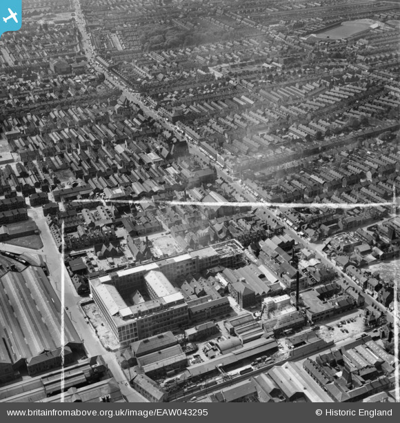
EAW043295 ENGLAND (1952). Hessle Road and the Smith and Nephew Associated Companies Ltd Factory on Neptune Street, Kingston upon Hull, 1952. This image was marked by Aerofilms Ltd for photo editing.
© Copyright OpenStreetMap contributors and licensed by the OpenStreetMap Foundation. 2025. Cartography is licensed as CC BY-SA.
Nearby Images (28)
Details
| Title | [EAW043295] Hessle Road and the Smith and Nephew Associated Companies Ltd Factory on Neptune Street, Kingston upon Hull, 1952. This image was marked by Aerofilms Ltd for photo editing. |
| Reference | EAW043295 |
| Date | 23-May-1952 |
| Link | |
| Place name | KINGSTON UPON HULL |
| Parish | |
| District | |
| Country | ENGLAND |
| Easting / Northing | 508460, 427896 |
| Longitude / Latitude | -0.35553574439909, 53.735934391586 |
| National Grid Reference | TA085279 |
Pins
 ladyceecee |
Friday 16th of August 2019 03:31:41 PM | |
 ladyceecee |
Friday 16th of August 2019 03:30:40 PM | |
 Genehunt1973 |
Wednesday 21st of September 2016 07:39:53 PM | |
 John Wass |
Wednesday 19th of August 2015 08:50:18 PM |


![[EAW043295] Hessle Road and the Smith and Nephew Associated Companies Ltd Factory on Neptune Street, Kingston upon Hull, 1952. This image was marked by Aerofilms Ltd for photo editing.](http://britainfromabove.org.uk/sites/all/libraries/aerofilms-images/public/100x100/EAW/043/EAW043295.jpg)
![[EAW035533] The Smith and Nephew Associated Companies Ltd Factory under construction off Neptune Street, Kingston upon Hull, 1951. This image has been produced from a print marked by Aerofilms Ltd for photo editing.](http://britainfromabove.org.uk/sites/all/libraries/aerofilms-images/public/100x100/EAW/035/EAW035533.jpg)
![[EAW043296] Hessle Road and the Smith and Nephew Associated Companies Ltd Factory on Neptune Street, Kingston upon Hull, 1952. This image was marked by Aerofilms Ltd for photo editing.](http://britainfromabove.org.uk/sites/all/libraries/aerofilms-images/public/100x100/EAW/043/EAW043296.jpg)
![[EAW043299] The Smith and Nephew Associated Companies Ltd Factory on Neptune Street and environs, Kingston upon Hull, 1952. This image was marked by Aerofilms Ltd for photo editing.](http://britainfromabove.org.uk/sites/all/libraries/aerofilms-images/public/100x100/EAW/043/EAW043299.jpg)
![[EAW035529] The Smith and Nephew Associated Companies Ltd Factory under construction off Neptune Street, Kingston upon Hull, 1951. This image has been produced from a print marked by Aerofilms Ltd for photo editing.](http://britainfromabove.org.uk/sites/all/libraries/aerofilms-images/public/100x100/EAW/035/EAW035529.jpg)
![[EAW031237] The Smith and Nephew Ltd Paragon Works and environs, Kingston upon Hull, 1950. This image was marked by Aerofilms Ltd for photo editing.](http://britainfromabove.org.uk/sites/all/libraries/aerofilms-images/public/100x100/EAW/031/EAW031237.jpg)
![[EAW031238] The Smith and Nephew Ltd Paragon Works and environs, Kingston upon Hull, 1950. This image was marked by Aerofilms Ltd for photo editing.](http://britainfromabove.org.uk/sites/all/libraries/aerofilms-images/public/100x100/EAW/031/EAW031238.jpg)
![[EAW035528] The Smith and Nephew Associated Companies Ltd Factory under construction off Neptune Street, Kingston upon Hull, 1951. This image has been produced from a print marked by Aerofilms Ltd for photo editing.](http://britainfromabove.org.uk/sites/all/libraries/aerofilms-images/public/100x100/EAW/035/EAW035528.jpg)
![[EAW015637] The Albert and William Wright Docks, Hessle Road and environs, Kingston upon Hull, 1948. This image has been produced from a print.](http://britainfromabove.org.uk/sites/all/libraries/aerofilms-images/public/100x100/EAW/015/EAW015637.jpg)
![[EAW031239] Construction underway at the Smith and Nephew Ltd Paragon Works site, Kingston upon Hull, 1950. This image was marked by Aerofilms Ltd for photo editing.](http://britainfromabove.org.uk/sites/all/libraries/aerofilms-images/public/100x100/EAW/031/EAW031239.jpg)
![[EAW043297] The Smith and Nephew Associated Companies Ltd Factory on Neptune Street looking towards the River Humber, Kingston upon Hull, 1952. This image was marked by Aerofilms Ltd for photo editing.](http://britainfromabove.org.uk/sites/all/libraries/aerofilms-images/public/100x100/EAW/043/EAW043297.jpg)
![[EAW031241] Construction underway at the Smith and Nephew Ltd Paragon Works site, Kingston upon Hull, 1950](http://britainfromabove.org.uk/sites/all/libraries/aerofilms-images/public/100x100/EAW/031/EAW031241.jpg)
![[EAW043300] The Smith and Nephew Associated Companies Ltd Factory on Neptune Street and environs, Kingston upon Hull, 1952. This image was marked by Aerofilms Ltd for photo editing.](http://britainfromabove.org.uk/sites/all/libraries/aerofilms-images/public/100x100/EAW/043/EAW043300.jpg)
![[EAW031235] Construction underway at the Smith and Nephew Ltd Paragon Works site, Kingston upon Hull, 1950. This image was marked by Aerofilms Ltd for photo editing.](http://britainfromabove.org.uk/sites/all/libraries/aerofilms-images/public/100x100/EAW/031/EAW031235.jpg)
![[EAW043294] Neptune Street Goods Station and the Smith and Nephew Associated Companies Ltd Factory on Neptune Street, Kingston upon Hull, 1952. This image was marked by Aerofilms Ltd for photo editing.](http://britainfromabove.org.uk/sites/all/libraries/aerofilms-images/public/100x100/EAW/043/EAW043294.jpg)
![[EAW031233] Construction underway at the Smith and Nephew Ltd Paragon Works site, Kingston upon Hull, 1950. This image was marked by Aerofilms Ltd for photo editing.](http://britainfromabove.org.uk/sites/all/libraries/aerofilms-images/public/100x100/EAW/031/EAW031233.jpg)
![[EAW031234] Construction underway at the Smith and Nephew Ltd Paragon Works site, Kingston upon Hull, 1950. This image was marked by Aerofilms Ltd for photo editing.](http://britainfromabove.org.uk/sites/all/libraries/aerofilms-images/public/100x100/EAW/031/EAW031234.jpg)
![[EPW055050] Hessle Road, Kingston upon Hull, 1937](http://britainfromabove.org.uk/sites/all/libraries/aerofilms-images/public/100x100/EPW/055/EPW055050.jpg)
![[EAW035536] The Smith and Nephew Associated Companies Ltd Factory under construction off Neptune Street, Kingston upon Hull, 1951. This image has been produced from a print marked by Aerofilms Ltd for photo editing.](http://britainfromabove.org.uk/sites/all/libraries/aerofilms-images/public/100x100/EAW/035/EAW035536.jpg)
![[EAW035531] The Smith and Nephew Associated Companies Ltd Factory under construction off Neptune Street, Kingston upon Hull, 1951. This image has been produced from a print marked by Aerofilms Ltd for photo editing.](http://britainfromabove.org.uk/sites/all/libraries/aerofilms-images/public/100x100/EAW/035/EAW035531.jpg)
![[EAW035532] The Smith and Nephew Associated Companies Ltd Factory under construction off Neptune Street, Kingston upon Hull, 1951. This image has been produced from a print marked by Aerofilms Ltd for photo editing.](http://britainfromabove.org.uk/sites/all/libraries/aerofilms-images/public/100x100/EAW/035/EAW035532.jpg)
![[EAW031236] The Smith and Nephew Ltd Paragon Works and environs, Kingston upon Hull, 1950. This image was marked by Aerofilms Ltd for photo editing.](http://britainfromabove.org.uk/sites/all/libraries/aerofilms-images/public/100x100/EAW/031/EAW031236.jpg)
![[EAW035534] The Smith and Nephew Associated Companies Ltd Factory under construction off Neptune Street, Kingston upon Hull, 1951. This image has been produced from a print marked by Aerofilms Ltd for photo editing.](http://britainfromabove.org.uk/sites/all/libraries/aerofilms-images/public/100x100/EAW/035/EAW035534.jpg)
![[EAW043293] The Smith and Nephew Associated Companies Ltd Factory on Neptune Street, Kingston upon Hull, 1952. This image was marked by Aerofilms Ltd for photo editing.](http://britainfromabove.org.uk/sites/all/libraries/aerofilms-images/public/100x100/EAW/043/EAW043293.jpg)
![[EAW035530] The Smith and Nephew Associated Companies Ltd Factory under construction off Neptune Street, Kingston upon Hull, 1951. This image has been produced from a print marked by Aerofilms Ltd for photo editing.](http://britainfromabove.org.uk/sites/all/libraries/aerofilms-images/public/100x100/EAW/035/EAW035530.jpg)
![[EAW043298] The Smith and Nephew Associated Companies Ltd Factory on Neptune Street and environs, Kingston upon Hull, 1952. This image was marked by Aerofilms Ltd for photo editing.](http://britainfromabove.org.uk/sites/all/libraries/aerofilms-images/public/100x100/EAW/043/EAW043298.jpg)
![[EAW031240] Construction underway at the Smith and Nephew Ltd Paragon Works site, Kingston upon Hull, 1950](http://britainfromabove.org.uk/sites/all/libraries/aerofilms-images/public/100x100/EAW/031/EAW031240.jpg)
![[EPW009399] The Albert Docks and Neptune Street Goods Station, Kingston upon Hull, 1923](http://britainfromabove.org.uk/sites/all/libraries/aerofilms-images/public/100x100/EPW/009/EPW009399.jpg)
