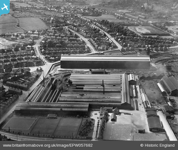
EPW057682 ENGLAND (1938). The Chesterfield Tube Company Ltd Works and environs, Chesterfield, 1938
© Copyright OpenStreetMap contributors and licensed by the OpenStreetMap Foundation. 2025. Cartography is licensed as CC BY-SA.
Nearby Images (7)
Details
| Title | [EPW057682] The Chesterfield Tube Company Ltd Works and environs, Chesterfield, 1938 |
| Reference | EPW057682 |
| Date | 20-June-1938 |
| Link | |
| Place name | CHESTERFIELD |
| Parish | |
| District | |
| Country | ENGLAND |
| Easting / Northing | 438260, 370309 |
| Longitude / Latitude | -1.4268105252697, 53.228161578641 |
| National Grid Reference | SK383703 |
Pins
 Whitwellian |
Saturday 19th of October 2013 01:29:31 AM |


![[EPW057682] The Chesterfield Tube Company Ltd Works and environs, Chesterfield, 1938](http://britainfromabove.org.uk/sites/all/libraries/aerofilms-images/public/100x100/EPW/057/EPW057682.jpg)
![[EPW057681] The Chesterfield Tube Company Ltd Works and environs, Chesterfield, 1938](http://britainfromabove.org.uk/sites/all/libraries/aerofilms-images/public/100x100/EPW/057/EPW057681.jpg)
![[EPW057679] The Chesterfield Tube Company Ltd Works, Chesterfield, 1938](http://britainfromabove.org.uk/sites/all/libraries/aerofilms-images/public/100x100/EPW/057/EPW057679.jpg)
![[EPW057684] The Chesterfield Tube Company Ltd Works and environs, Chesterfield, 1938](http://britainfromabove.org.uk/sites/all/libraries/aerofilms-images/public/100x100/EPW/057/EPW057684.jpg)
![[EPW057680] The Chesterfield Tube Company Ltd Works and environs, Chesterfield, 1938](http://britainfromabove.org.uk/sites/all/libraries/aerofilms-images/public/100x100/EPW/057/EPW057680.jpg)
![[EPW057683] The Chesterfield Tube Company Ltd Works and environs, Chesterfield, 1938](http://britainfromabove.org.uk/sites/all/libraries/aerofilms-images/public/100x100/EPW/057/EPW057683.jpg)
![[EPW057685] The Chesterfield Tube Company Ltd Works and environs, Chesterfield, 1938](http://britainfromabove.org.uk/sites/all/libraries/aerofilms-images/public/100x100/EPW/057/EPW057685.jpg)