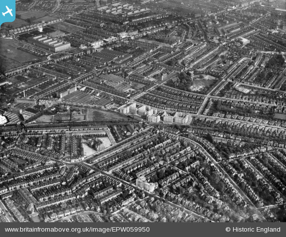
EPW059950 ENGLAND (1938). Emlyn Gardens and environs, Hammersmith, 1938. This image has been produced from a print.
© Copyright OpenStreetMap contributors and licensed by the OpenStreetMap Foundation. 2025. Cartography is licensed as CC BY-SA.
Nearby Images (14)
Details
| Title | [EPW059950] Emlyn Gardens and environs, Hammersmith, 1938. This image has been produced from a print. |
| Reference | EPW059950 |
| Date | 15-October-1938 |
| Link | |
| Place name | HAMMERSMITH |
| Parish | |
| District | |
| Country | ENGLAND |
| Easting / Northing | 521378, 179555 |
| Longitude / Latitude | -0.25107622376614, 51.501398126707 |
| National Grid Reference | TQ214796 |


![[EPW059950] Emlyn Gardens and environs, Hammersmith, 1938. This image has been produced from a print.](http://britainfromabove.org.uk/sites/all/libraries/aerofilms-images/public/100x100/EPW/059/EPW059950.jpg)
![[EAW031003] The Acton Park Industrial Estate and environs, Acton, 1950. This image was marked by Aerofilms Ltd for photo editing.](http://britainfromabove.org.uk/sites/all/libraries/aerofilms-images/public/100x100/EAW/031/EAW031003.jpg)
![[EPW062160] The C.A.V.-Bosch Ltd Electrical Engineering Works, Acton, 1939](http://britainfromabove.org.uk/sites/all/libraries/aerofilms-images/public/100x100/EPW/062/EPW062160.jpg)
![[EAW031001] The Acton Park Industrial Estate and environs, Acton, 1950. This image was marked by Aerofilms Ltd for photo editing.](http://britainfromabove.org.uk/sites/all/libraries/aerofilms-images/public/100x100/EAW/031/EAW031001.jpg)
![[EAW031002] The Acton Park Industrial Estate and environs, Acton, 1950. This image was marked by Aerofilms Ltd for photo editing.](http://britainfromabove.org.uk/sites/all/libraries/aerofilms-images/public/100x100/EAW/031/EAW031002.jpg)
![[EAW030998] The Acton Park Industrial Estate and environs, Acton, 1950. This image was marked by Aerofilms Ltd for photo editing.](http://britainfromabove.org.uk/sites/all/libraries/aerofilms-images/public/100x100/EAW/030/EAW030998.jpg)
![[EPW062161] The C.A.V.-Bosch Ltd Electrical Engineering Works, Acton, 1939](http://britainfromabove.org.uk/sites/all/libraries/aerofilms-images/public/100x100/EPW/062/EPW062161.jpg)
![[EAW030997] The Acton Park Industrial Estate and environs, Hammersmith, 1950. This image was marked by Aerofilms Ltd for photo editing.](http://britainfromabove.org.uk/sites/all/libraries/aerofilms-images/public/100x100/EAW/030/EAW030997.jpg)
![[EAW031004] The Acton Park Industrial Estate and environs, Acton, 1950. This image was marked by Aerofilms Ltd for photo editing.](http://britainfromabove.org.uk/sites/all/libraries/aerofilms-images/public/100x100/EAW/031/EAW031004.jpg)
![[EAW031006] The Acton Park Industrial Estate and environs, Hammersmith, 1950. This image was marked by Aerofilms Ltd for photo editing.](http://britainfromabove.org.uk/sites/all/libraries/aerofilms-images/public/100x100/EAW/031/EAW031006.jpg)
![[EAW031005] The Acton Park Industrial Estate and environs, Hammersmith, 1950. This image was marked by Aerofilms Ltd for photo editing.](http://britainfromabove.org.uk/sites/all/libraries/aerofilms-images/public/100x100/EAW/031/EAW031005.jpg)
![[EPW020848] Engineering Works and Motor Coach Works on Warple Way, Acton, 1928](http://britainfromabove.org.uk/sites/all/libraries/aerofilms-images/public/100x100/EPW/020/EPW020848.jpg)
![[EPW020849] Engineering Works and Motor Coach Works on Warple Way, Acton, 1928](http://britainfromabove.org.uk/sites/all/libraries/aerofilms-images/public/100x100/EPW/020/EPW020849.jpg)
![[EPW062163] The C.A.V.-Bosch Ltd Electrical Engineering Works and other factories, Acton, 1939](http://britainfromabove.org.uk/sites/all/libraries/aerofilms-images/public/100x100/EPW/062/EPW062163.jpg)

