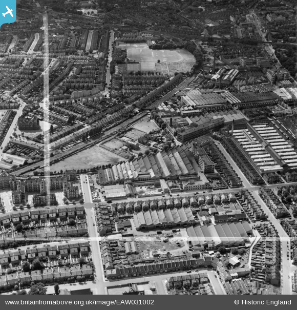
EAW031002 ENGLAND (1950). The Acton Park Industrial Estate and environs, Acton, 1950. This image was marked by Aerofilms Ltd for photo editing.
© Copyright OpenStreetMap contributors and licensed by the OpenStreetMap Foundation. 2025. Cartography is licensed as CC BY-SA.
Nearby Images (28)
Details
| Title | [EAW031002] The Acton Park Industrial Estate and environs, Acton, 1950. This image was marked by Aerofilms Ltd for photo editing. |
| Reference | EAW031002 |
| Date | 14-July-1950 |
| Link | |
| Place name | ACTON |
| Parish | |
| District | |
| Country | ENGLAND |
| Easting / Northing | 521240, 179727 |
| Longitude / Latitude | -0.25300452812459, 51.502973741934 |
| National Grid Reference | TQ212797 |
Pins
 Leslie B |
Sunday 27th of March 2016 12:00:04 AM |


![[EAW031002] The Acton Park Industrial Estate and environs, Acton, 1950. This image was marked by Aerofilms Ltd for photo editing.](http://britainfromabove.org.uk/sites/all/libraries/aerofilms-images/public/100x100/EAW/031/EAW031002.jpg)
![[EAW030998] The Acton Park Industrial Estate and environs, Acton, 1950. This image was marked by Aerofilms Ltd for photo editing.](http://britainfromabove.org.uk/sites/all/libraries/aerofilms-images/public/100x100/EAW/030/EAW030998.jpg)
![[EAW031004] The Acton Park Industrial Estate and environs, Acton, 1950. This image was marked by Aerofilms Ltd for photo editing.](http://britainfromabove.org.uk/sites/all/libraries/aerofilms-images/public/100x100/EAW/031/EAW031004.jpg)
![[EAW031001] The Acton Park Industrial Estate and environs, Acton, 1950. This image was marked by Aerofilms Ltd for photo editing.](http://britainfromabove.org.uk/sites/all/libraries/aerofilms-images/public/100x100/EAW/031/EAW031001.jpg)
![[EPW062160] The C.A.V.-Bosch Ltd Electrical Engineering Works, Acton, 1939](http://britainfromabove.org.uk/sites/all/libraries/aerofilms-images/public/100x100/EPW/062/EPW062160.jpg)
![[EPW062161] The C.A.V.-Bosch Ltd Electrical Engineering Works, Acton, 1939](http://britainfromabove.org.uk/sites/all/libraries/aerofilms-images/public/100x100/EPW/062/EPW062161.jpg)
![[EAW030997] The Acton Park Industrial Estate and environs, Hammersmith, 1950. This image was marked by Aerofilms Ltd for photo editing.](http://britainfromabove.org.uk/sites/all/libraries/aerofilms-images/public/100x100/EAW/030/EAW030997.jpg)
![[EPW020848] Engineering Works and Motor Coach Works on Warple Way, Acton, 1928](http://britainfromabove.org.uk/sites/all/libraries/aerofilms-images/public/100x100/EPW/020/EPW020848.jpg)
![[EAW031003] The Acton Park Industrial Estate and environs, Acton, 1950. This image was marked by Aerofilms Ltd for photo editing.](http://britainfromabove.org.uk/sites/all/libraries/aerofilms-images/public/100x100/EAW/031/EAW031003.jpg)
![[EPW020849] Engineering Works and Motor Coach Works on Warple Way, Acton, 1928](http://britainfromabove.org.uk/sites/all/libraries/aerofilms-images/public/100x100/EPW/020/EPW020849.jpg)
![[EAW031006] The Acton Park Industrial Estate and environs, Hammersmith, 1950. This image was marked by Aerofilms Ltd for photo editing.](http://britainfromabove.org.uk/sites/all/libraries/aerofilms-images/public/100x100/EAW/031/EAW031006.jpg)
![[EAW031000] The Acton Park Industrial Estate and environs, Hammersmith, 1950. This image was marked by Aerofilms Ltd for photo editing.](http://britainfromabove.org.uk/sites/all/libraries/aerofilms-images/public/100x100/EAW/031/EAW031000.jpg)
![[EPW020852] Engineering Works and Motor Coach Works on Warple Way, Acton, 1928](http://britainfromabove.org.uk/sites/all/libraries/aerofilms-images/public/100x100/EPW/020/EPW020852.jpg)
![[EPW062158] The C.A.V.-Bosch Ltd Electrical Engineering Works, Acton, 1939](http://britainfromabove.org.uk/sites/all/libraries/aerofilms-images/public/100x100/EPW/062/EPW062158.jpg)
![[EPW062163] The C.A.V.-Bosch Ltd Electrical Engineering Works and other factories, Acton, 1939](http://britainfromabove.org.uk/sites/all/libraries/aerofilms-images/public/100x100/EPW/062/EPW062163.jpg)
![[EPW020846] C.A. Vandervell and Co Engineering Works, Acton, 1928](http://britainfromabove.org.uk/sites/all/libraries/aerofilms-images/public/100x100/EPW/020/EPW020846.jpg)
![[EPW020856] Engineering Works and Motor Coach Works on Warple Way, Acton, 1928](http://britainfromabove.org.uk/sites/all/libraries/aerofilms-images/public/100x100/EPW/020/EPW020856.jpg)
![[EPW020850] Engineering Works and Motor Coach Works on Warple Way, Acton, 1928](http://britainfromabove.org.uk/sites/all/libraries/aerofilms-images/public/100x100/EPW/020/EPW020850.jpg)
![[EAW031005] The Acton Park Industrial Estate and environs, Hammersmith, 1950. This image was marked by Aerofilms Ltd for photo editing.](http://britainfromabove.org.uk/sites/all/libraries/aerofilms-images/public/100x100/EAW/031/EAW031005.jpg)
![[EAW030999] The Acton Park Industrial Estate and environs, Acton, 1950. This image was marked by Aerofilms Ltd for photo editing.](http://britainfromabove.org.uk/sites/all/libraries/aerofilms-images/public/100x100/EAW/030/EAW030999.jpg)
![[EPW062164] The C.A.V.-Bosch Ltd Electrical Engineering Works and other factories, Acton, from the north-east, 1939](http://britainfromabove.org.uk/sites/all/libraries/aerofilms-images/public/100x100/EPW/062/EPW062164.jpg)
![[EPW020847] Engineering Works and Motor Coach Works on Warple Way, Acton, 1928](http://britainfromabove.org.uk/sites/all/libraries/aerofilms-images/public/100x100/EPW/020/EPW020847.jpg)
![[EPW014096] Works off Warple Way, Acton, 1925. This image has been produced from a print.](http://britainfromabove.org.uk/sites/all/libraries/aerofilms-images/public/100x100/EPW/014/EPW014096.jpg)
![[EPW062159] The C.A.V.-Bosch Ltd Electrical Engineering Works and other factories, Acton, from the north-east, 1939](http://britainfromabove.org.uk/sites/all/libraries/aerofilms-images/public/100x100/EPW/062/EPW062159.jpg)
![[EPW062162] The C.A.V.-Bosch Ltd Electrical Engineering Works and other factories, Acton, 1939](http://britainfromabove.org.uk/sites/all/libraries/aerofilms-images/public/100x100/EPW/062/EPW062162.jpg)
![[EPW062165] The C.A.V.-Bosch Ltd Electrical Engineering Works and other factories, Acton, from the north-east, 1939](http://britainfromabove.org.uk/sites/all/libraries/aerofilms-images/public/100x100/EPW/062/EPW062165.jpg)
![[EPW059950] Emlyn Gardens and environs, Hammersmith, 1938. This image has been produced from a print.](http://britainfromabove.org.uk/sites/all/libraries/aerofilms-images/public/100x100/EPW/059/EPW059950.jpg)
![[EPW020855] Engineering Works and Motor Coach Works on Warple Way, Acton, from the north-east, 1928](http://britainfromabove.org.uk/sites/all/libraries/aerofilms-images/public/100x100/EPW/020/EPW020855.jpg)