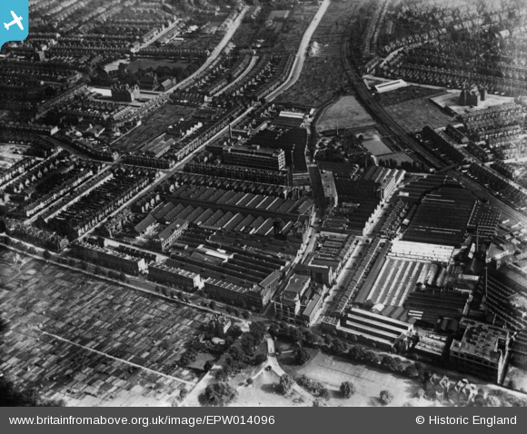
EPW014096 ENGLAND (1925). Works off Warple Way, Acton, 1925. This image has been produced from a print.
© Copyright OpenStreetMap contributors and licensed by the OpenStreetMap Foundation. 2025. Cartography is licensed as CC BY-SA.
Nearby Images (29)
Details
| Title | [EPW014096] Works off Warple Way, Acton, 1925. This image has been produced from a print. |
| Reference | EPW014096 |
| Date | 19-August-1925 |
| Link | |
| Place name | ACTON |
| Parish | |
| District | |
| Country | ENGLAND |
| Easting / Northing | 521200, 179900 |
| Longitude / Latitude | -0.25352115701422, 51.504537302185 |
| National Grid Reference | TQ212799 |
Pins
 popstar |
Wednesday 16th of September 2020 09:28:18 PM | |
 houds |
Monday 13th of July 2015 06:05:51 PM | |
 peterhurst |
Sunday 3rd of May 2015 12:28:25 PM | |
 peterhurst |
Sunday 3rd of May 2015 12:26:30 PM |


![[EPW014096] Works off Warple Way, Acton, 1925. This image has been produced from a print.](http://britainfromabove.org.uk/sites/all/libraries/aerofilms-images/public/100x100/EPW/014/EPW014096.jpg)
![[EPW020847] Engineering Works and Motor Coach Works on Warple Way, Acton, 1928](http://britainfromabove.org.uk/sites/all/libraries/aerofilms-images/public/100x100/EPW/020/EPW020847.jpg)
![[EAW030999] The Acton Park Industrial Estate and environs, Acton, 1950. This image was marked by Aerofilms Ltd for photo editing.](http://britainfromabove.org.uk/sites/all/libraries/aerofilms-images/public/100x100/EAW/030/EAW030999.jpg)
![[EPW062162] The C.A.V.-Bosch Ltd Electrical Engineering Works and other factories, Acton, 1939](http://britainfromabove.org.uk/sites/all/libraries/aerofilms-images/public/100x100/EPW/062/EPW062162.jpg)
![[EPW020850] Engineering Works and Motor Coach Works on Warple Way, Acton, 1928](http://britainfromabove.org.uk/sites/all/libraries/aerofilms-images/public/100x100/EPW/020/EPW020850.jpg)
![[EPW020846] C.A. Vandervell and Co Engineering Works, Acton, 1928](http://britainfromabove.org.uk/sites/all/libraries/aerofilms-images/public/100x100/EPW/020/EPW020846.jpg)
![[EAW031000] The Acton Park Industrial Estate and environs, Hammersmith, 1950. This image was marked by Aerofilms Ltd for photo editing.](http://britainfromabove.org.uk/sites/all/libraries/aerofilms-images/public/100x100/EAW/031/EAW031000.jpg)
![[EPW020852] Engineering Works and Motor Coach Works on Warple Way, Acton, 1928](http://britainfromabove.org.uk/sites/all/libraries/aerofilms-images/public/100x100/EPW/020/EPW020852.jpg)
![[EPW062158] The C.A.V.-Bosch Ltd Electrical Engineering Works, Acton, 1939](http://britainfromabove.org.uk/sites/all/libraries/aerofilms-images/public/100x100/EPW/062/EPW062158.jpg)
![[EPW020856] Engineering Works and Motor Coach Works on Warple Way, Acton, 1928](http://britainfromabove.org.uk/sites/all/libraries/aerofilms-images/public/100x100/EPW/020/EPW020856.jpg)
![[EPW020849] Engineering Works and Motor Coach Works on Warple Way, Acton, 1928](http://britainfromabove.org.uk/sites/all/libraries/aerofilms-images/public/100x100/EPW/020/EPW020849.jpg)
![[EPW020848] Engineering Works and Motor Coach Works on Warple Way, Acton, 1928](http://britainfromabove.org.uk/sites/all/libraries/aerofilms-images/public/100x100/EPW/020/EPW020848.jpg)
![[EPW062159] The C.A.V.-Bosch Ltd Electrical Engineering Works and other factories, Acton, from the north-east, 1939](http://britainfromabove.org.uk/sites/all/libraries/aerofilms-images/public/100x100/EPW/062/EPW062159.jpg)
![[EPW062163] The C.A.V.-Bosch Ltd Electrical Engineering Works and other factories, Acton, 1939](http://britainfromabove.org.uk/sites/all/libraries/aerofilms-images/public/100x100/EPW/062/EPW062163.jpg)
![[EAW031006] The Acton Park Industrial Estate and environs, Hammersmith, 1950. This image was marked by Aerofilms Ltd for photo editing.](http://britainfromabove.org.uk/sites/all/libraries/aerofilms-images/public/100x100/EAW/031/EAW031006.jpg)
![[EPW062165] The C.A.V.-Bosch Ltd Electrical Engineering Works and other factories, Acton, from the north-east, 1939](http://britainfromabove.org.uk/sites/all/libraries/aerofilms-images/public/100x100/EPW/062/EPW062165.jpg)
![[EPW062164] The C.A.V.-Bosch Ltd Electrical Engineering Works and other factories, Acton, from the north-east, 1939](http://britainfromabove.org.uk/sites/all/libraries/aerofilms-images/public/100x100/EPW/062/EPW062164.jpg)
![[EAW030997] The Acton Park Industrial Estate and environs, Hammersmith, 1950. This image was marked by Aerofilms Ltd for photo editing.](http://britainfromabove.org.uk/sites/all/libraries/aerofilms-images/public/100x100/EAW/030/EAW030997.jpg)
![[EPW020855] Engineering Works and Motor Coach Works on Warple Way, Acton, from the north-east, 1928](http://britainfromabove.org.uk/sites/all/libraries/aerofilms-images/public/100x100/EPW/020/EPW020855.jpg)
![[EPW062161] The C.A.V.-Bosch Ltd Electrical Engineering Works, Acton, 1939](http://britainfromabove.org.uk/sites/all/libraries/aerofilms-images/public/100x100/EPW/062/EPW062161.jpg)
![[EAW031004] The Acton Park Industrial Estate and environs, Acton, 1950. This image was marked by Aerofilms Ltd for photo editing.](http://britainfromabove.org.uk/sites/all/libraries/aerofilms-images/public/100x100/EAW/031/EAW031004.jpg)
![[EAW031005] The Acton Park Industrial Estate and environs, Hammersmith, 1950. This image was marked by Aerofilms Ltd for photo editing.](http://britainfromabove.org.uk/sites/all/libraries/aerofilms-images/public/100x100/EAW/031/EAW031005.jpg)
![[EAW030998] The Acton Park Industrial Estate and environs, Acton, 1950. This image was marked by Aerofilms Ltd for photo editing.](http://britainfromabove.org.uk/sites/all/libraries/aerofilms-images/public/100x100/EAW/030/EAW030998.jpg)
![[EAW031002] The Acton Park Industrial Estate and environs, Acton, 1950. This image was marked by Aerofilms Ltd for photo editing.](http://britainfromabove.org.uk/sites/all/libraries/aerofilms-images/public/100x100/EAW/031/EAW031002.jpg)
![[EPW062160] The C.A.V.-Bosch Ltd Electrical Engineering Works, Acton, 1939](http://britainfromabove.org.uk/sites/all/libraries/aerofilms-images/public/100x100/EPW/062/EPW062160.jpg)
![[EAW031001] The Acton Park Industrial Estate and environs, Acton, 1950. This image was marked by Aerofilms Ltd for photo editing.](http://britainfromabove.org.uk/sites/all/libraries/aerofilms-images/public/100x100/EAW/031/EAW031001.jpg)
![[EAW031003] The Acton Park Industrial Estate and environs, Acton, 1950. This image was marked by Aerofilms Ltd for photo editing.](http://britainfromabove.org.uk/sites/all/libraries/aerofilms-images/public/100x100/EAW/031/EAW031003.jpg)
![[EPW044578] The D. Napier & Son Ltd Engineering Works and the Eastman and Son Dyeing and Cleaning Works, Acton, 1934](http://britainfromabove.org.uk/sites/all/libraries/aerofilms-images/public/100x100/EPW/044/EPW044578.jpg)
![[EPW044641] The D. Napier & Son Ltd Engineering Works and the Eastman and Son Dyeing and Cleaning Works, Acton, 1934](http://britainfromabove.org.uk/sites/all/libraries/aerofilms-images/public/100x100/EPW/044/EPW044641.jpg)