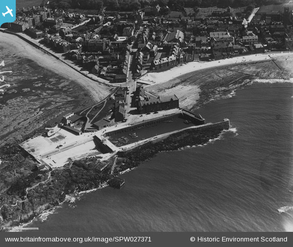
SPW027371 SCOTLAND (1929). North Berwick Harbour. An oblique aerial photograph taken facing south. This image has been produced from a marked print.
© Copyright OpenStreetMap contributors and licensed by the OpenStreetMap Foundation. 2025. Cartography is licensed as CC BY-SA.
Nearby Images (13)
Details
| Title | [SPW027371] North Berwick Harbour. An oblique aerial photograph taken facing south. This image has been produced from a marked print. |
| Reference | SPW027371 |
| Date | 1929 |
| Link | Canmore Collection item 1315459 |
| Place name | |
| Parish | NORTH BERWICK |
| District | EAST LOTHIAN |
| Country | SCOTLAND |
| Easting / Northing | 355347, 685566 |
| Longitude / Latitude | -2.7171669541537, 56.060907589766 |
| National Grid Reference | NT553856 |
Pins
Be the first to add a comment to this image!


![[SPW027371] North Berwick Harbour. An oblique aerial photograph taken facing south. This image has been produced from a marked print.](http://britainfromabove.org.uk/sites/all/libraries/aerofilms-images/public/100x100/SPW/027/SPW027371.jpg)
![[SPW027367] North Berwick Bay. An oblique aerial photograph taken facing south-east. This image has been produced from a print.](http://britainfromabove.org.uk/sites/all/libraries/aerofilms-images/public/100x100/SPW/027/SPW027367.jpg)
![[SAW032099] North Berwick Harbour. An oblique aerial photograph taken facing north.](http://britainfromabove.org.uk/sites/all/libraries/aerofilms-images/public/100x100/SAW/032/SAW032099.jpg)
![[SAW032132] North Berwick, general view, showing North Berwick Harbour and Law Road. An oblique aerial photograph taken facing south.](http://britainfromabove.org.uk/sites/all/libraries/aerofilms-images/public/100x100/SAW/032/SAW032132.jpg)
![[SAW032133] North Berwick, general view, showing North Berwick Harbour and North Berwick Law. An oblique aerial photograph taken facing south.](http://britainfromabove.org.uk/sites/all/libraries/aerofilms-images/public/100x100/SAW/032/SAW032133.jpg)
![[SPW027369] North Berwick, general view, showing North Berwick Harbour and Quality Street. An oblique aerial photograph taken facing north. This image has been produced from a print.](http://britainfromabove.org.uk/sites/all/libraries/aerofilms-images/public/100x100/SPW/027/SPW027369.jpg)
![[SPW027374] North Berwick, general view, showing North Berwick Harbour and Quality Street. An oblique aerial photograph taken facing north. This image has been produced from a marked print.](http://britainfromabove.org.uk/sites/all/libraries/aerofilms-images/public/100x100/SPW/027/SPW027374.jpg)
![[SAR018890] General View North Berwick, East Lothian, Scotland. An oblique aerial photograph taken facing South/East.](http://britainfromabove.org.uk/sites/all/libraries/aerofilms-images/public/100x100/SAR/018/SAR018890.jpg)
![[SAR018891] General View North Berwick, East Lothian, Scotland. An oblique aerial photograph taken facing North/East. This image was marked by AeroPictorial Ltd for photo editing.](http://britainfromabove.org.uk/sites/all/libraries/aerofilms-images/public/100x100/SAR/018/SAR018891.jpg)
![[SAR018892] General View North Berwick, East Lothian, Scotland. An oblique aerial photograph taken facing North.](http://britainfromabove.org.uk/sites/all/libraries/aerofilms-images/public/100x100/SAR/018/SAR018892.jpg)
![[SAR018906] General View North Berwick, East Lothian, Scotland. An oblique aerial photograph taken facing South.](http://britainfromabove.org.uk/sites/all/libraries/aerofilms-images/public/100x100/SAR/018/SAR018906.jpg)
![[SAR018907] General View North Berwick, East Lothian, Scotland. An oblique aerial photograph taken facing South/East.](http://britainfromabove.org.uk/sites/all/libraries/aerofilms-images/public/100x100/SAR/018/SAR018907.jpg)
![[SAR031670] General View North Berwick, East Lothian, Scotland. An oblique aerial photograph taken facing West.](http://britainfromabove.org.uk/sites/all/libraries/aerofilms-images/public/100x100/SAR/031/SAR031670.jpg)