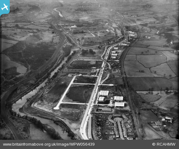
WPW056439 WALES (1938). View of the Treforest trading estate under construction, oblique aerial view. 5"x4" black and white glass plate negative.
© Copyright OpenStreetMap contributors and licensed by the OpenStreetMap Foundation. 2025. Cartography is licensed as CC BY-SA.
Nearby Images (38)
Details
| Title | [WPW056439] View of the Treforest trading estate under construction, oblique aerial view. 5"x4" black and white glass plate negative. |
| Reference | WPW056439 |
| Date | 1938 |
| Link | Coflein Archive Item 6370441 |
| Place name | |
| Parish | |
| District | |
| Country | WALES |
| Easting / Northing | 311100, 186100 |
| Longitude / Latitude | -3.2827534768246, 51.566282440262 |
| National Grid Reference | ST111861 |
Pins
Be the first to add a comment to this image!


![[WAW018006] General view of Treforest Trading Estate. Oblique aerial photograph, 5½" cut roll film.](http://britainfromabove.org.uk/sites/all/libraries/aerofilms-images/public/100x100/WAW/018/WAW018006.jpg)
![[WAW018007] General view of Treforest Trading Estate. Oblique aerial photograph, 5½" cut roll film.](http://britainfromabove.org.uk/sites/all/libraries/aerofilms-images/public/100x100/WAW/018/WAW018007.jpg)
![[WAW050536] View of Treforest Chemical Co. Ltd, Treforest Trading estate](http://britainfromabove.org.uk/sites/all/libraries/aerofilms-images/public/100x100/WAW/050/WAW050536.jpg)
![[WAW050537] View of Treforest Chemical Co. Ltd, Treforest Trading estate](http://britainfromabove.org.uk/sites/all/libraries/aerofilms-images/public/100x100/WAW/050/WAW050537.jpg)
![[WAW050538] View of Treforest Chemical Co. Ltd, Treforest Trading estate](http://britainfromabove.org.uk/sites/all/libraries/aerofilms-images/public/100x100/WAW/050/WAW050538.jpg)
![[WAW050539] View of Treforest Chemical Co. Ltd, Treforest Trading estate](http://britainfromabove.org.uk/sites/all/libraries/aerofilms-images/public/100x100/WAW/050/WAW050539.jpg)
![[WAW050540] View of Treforest Chemical Co. Ltd, Treforest Trading estate](http://britainfromabove.org.uk/sites/all/libraries/aerofilms-images/public/100x100/WAW/050/WAW050540.jpg)
![[WAW050541] View of Treforest Chemical Co. Ltd, Treforest Trading estate](http://britainfromabove.org.uk/sites/all/libraries/aerofilms-images/public/100x100/WAW/050/WAW050541.jpg)
![[WAW050542] View of Treforest Chemical Co. Ltd, Treforest Trading estate](http://britainfromabove.org.uk/sites/all/libraries/aerofilms-images/public/100x100/WAW/050/WAW050542.jpg)
![[WAW050543] View of Treforest Chemical Co. Ltd, Treforest Trading estate](http://britainfromabove.org.uk/sites/all/libraries/aerofilms-images/public/100x100/WAW/050/WAW050543.jpg)
![[WAW050544] View of Treforest Chemical Co. Ltd, Treforest Trading estate](http://britainfromabove.org.uk/sites/all/libraries/aerofilms-images/public/100x100/WAW/050/WAW050544.jpg)
![[WAW050545] View of Treforest Chemical Co. Ltd, Treforest Trading estate](http://britainfromabove.org.uk/sites/all/libraries/aerofilms-images/public/100x100/WAW/050/WAW050545.jpg)
![[WAW050546] View of Treforest Chemical Co. Ltd, Treforest Trading estate](http://britainfromabove.org.uk/sites/all/libraries/aerofilms-images/public/100x100/WAW/050/WAW050546.jpg)
![[WAW050547] View of Treforest Chemical Co. Ltd, Treforest Trading estate](http://britainfromabove.org.uk/sites/all/libraries/aerofilms-images/public/100x100/WAW/050/WAW050547.jpg)
![[WPW029840A] View of Electric power station near Treforest Trading Estate, oblique aerial view. 5"x4" black and white glass plate negative.](http://britainfromabove.org.uk/sites/all/libraries/aerofilms-images/public/100x100/WPW/029/WPW029840A.jpg)
![[WPW029853] View of Electric power station near Treforest Trading Estate, oblique aerial view. 5"x4" black and white glass plate negative.](http://britainfromabove.org.uk/sites/all/libraries/aerofilms-images/public/100x100/WPW/029/WPW029853.jpg)
![[WPW029854] View of Electric power station near Treforest Trading Estate, oblique aerial view. 5"x4" black and white glass plate negative.](http://britainfromabove.org.uk/sites/all/libraries/aerofilms-images/public/100x100/WPW/029/WPW029854.jpg)
![[WPW029855] View of Electric power station near Treforest Trading Estate, oblique aerial view. 5"x4" black and white glass plate negative.](http://britainfromabove.org.uk/sites/all/libraries/aerofilms-images/public/100x100/WPW/029/WPW029855.jpg)
![[WPW029856] View of Electric power station near Treforest Trading Estate, oblique aerial view. 5"x4" black and white glass plate negative.](http://britainfromabove.org.uk/sites/all/libraries/aerofilms-images/public/100x100/WPW/029/WPW029856.jpg)
![[WPW029857] View of Electric power station near Treforest Trading Estate, oblique aerial view. 5"x4" black and white glass plate negative.](http://britainfromabove.org.uk/sites/all/libraries/aerofilms-images/public/100x100/WPW/029/WPW029857.jpg)
![[WPW054900] View of Treforest trading estate under construction, looking south east. Oblique aerial photograph, 5"x4" BW glass plate.](http://britainfromabove.org.uk/sites/all/libraries/aerofilms-images/public/100x100/WPW/054/WPW054900.jpg)
![[WPW055417] View of site of Treforest Industrial Estate prior to construction, oblique aerial view. 5"x4" black and white glass plate negative.](http://britainfromabove.org.uk/sites/all/libraries/aerofilms-images/public/100x100/WPW/055/WPW055417.jpg)
![[WPW055422] View of Treforest Trading estate. Oblique aerial photograph, 5"x4" BW glass plate.](http://britainfromabove.org.uk/sites/all/libraries/aerofilms-images/public/100x100/WPW/055/WPW055422.jpg)
![[WPW055427] View of Treforest Trading estate. Oblique aerial photograph, 5"x4" BW glass plate.](http://britainfromabove.org.uk/sites/all/libraries/aerofilms-images/public/100x100/WPW/055/WPW055427.jpg)
![[WPW056435] View of the Treforest trading estate under construction, oblique aerial view. 5"x4" black and white glass plate negative.](http://britainfromabove.org.uk/sites/all/libraries/aerofilms-images/public/100x100/WPW/056/WPW056435.jpg)
![[WPW056436] View of the Treforest trading estate under construction, oblique aerial view. 5"x4" black and white glass plate negative.](http://britainfromabove.org.uk/sites/all/libraries/aerofilms-images/public/100x100/WPW/056/WPW056436.jpg)
![[WPW056437] View of the Treforest trading estate under construction, oblique aerial view. 5"x4" black and white glass plate negative.](http://britainfromabove.org.uk/sites/all/libraries/aerofilms-images/public/100x100/WPW/056/WPW056437.jpg)
![[WPW056438] View of the Treforest trading estate under construction, oblique aerial view. 5"x4" black and white glass plate negative.](http://britainfromabove.org.uk/sites/all/libraries/aerofilms-images/public/100x100/WPW/056/WPW056438.jpg)
![[WPW056439] View of the Treforest trading estate under construction, oblique aerial view. 5"x4" black and white glass plate negative.](http://britainfromabove.org.uk/sites/all/libraries/aerofilms-images/public/100x100/WPW/056/WPW056439.jpg)
![[WPW056440] View of the Treforest trading estate under construction, oblique aerial view. 5"x4" black and white glass plate negative.](http://britainfromabove.org.uk/sites/all/libraries/aerofilms-images/public/100x100/WPW/056/WPW056440.jpg)
![[WPW060734] View of Pritchard, Wood & Partners, Treforest Trading Estate, oblique aerial view. 5"x4" black and white glass plate negative.](http://britainfromabove.org.uk/sites/all/libraries/aerofilms-images/public/100x100/WPW/060/WPW060734.jpg)
![[WPW060735] View of Pritchard, Wood & Partners, Treforest Trading Estate, oblique aerial view. 5"x4" black and white glass plate negative.](http://britainfromabove.org.uk/sites/all/libraries/aerofilms-images/public/100x100/WPW/060/WPW060735.jpg)
![[WPW060736] View of Pritchard, Wood & Partners, Treforest Trading Estate, oblique aerial view. 5"x4" black and white glass plate negative.](http://britainfromabove.org.uk/sites/all/libraries/aerofilms-images/public/100x100/WPW/060/WPW060736.jpg)
![[WPW060737] View of Pritchard, Wood & Partners, Treforest Trading Estate, oblique aerial view. 5"x4" black and white glass plate negative.](http://britainfromabove.org.uk/sites/all/libraries/aerofilms-images/public/100x100/WPW/060/WPW060737.jpg)
![[WPW060738] View of Pritchard, Wood & Partners, Treforest Trading Estate, oblique aerial view. 5"x4" black and white glass plate negative.](http://britainfromabove.org.uk/sites/all/libraries/aerofilms-images/public/100x100/WPW/060/WPW060738.jpg)
![[WPW060739] View of Pritchard, Wood & Partners, Treforest Trading Estate, oblique aerial view. 5"x4" black and white glass plate negative.](http://britainfromabove.org.uk/sites/all/libraries/aerofilms-images/public/100x100/WPW/060/WPW060739.jpg)
![[WPW060740] View of Pritchard, Wood & Partners, Treforest Trading Estate, oblique aerial view. 5"x4" black and white glass plate negative.](http://britainfromabove.org.uk/sites/all/libraries/aerofilms-images/public/100x100/WPW/060/WPW060740.jpg)
![[WPW060741] View of Pritchard, Wood & Partners, Treforest Trading Estate, oblique aerial view. 5"x4" black and white glass plate negative.](http://britainfromabove.org.uk/sites/all/libraries/aerofilms-images/public/100x100/WPW/060/WPW060741.jpg)