
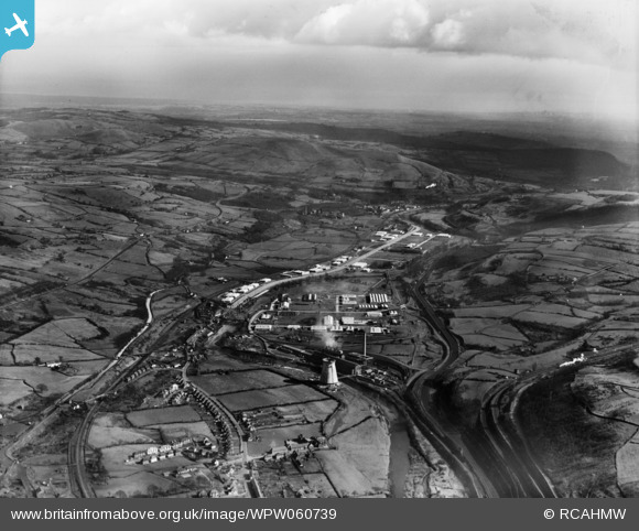
WPW060739 WALES (1939). View of Pritchard, Wood & Partners, Treforest Trading Estate, oblique aerial view. 5"x4" black and white glass plate negative.
© Copyright OpenStreetMap contributors and licensed by the OpenStreetMap Foundation. 2025. Cartography is licensed as CC BY-SA.
Nearby Images (38)
WAW018006

WAW018007

WAW050536

WAW050537

WAW050538

WAW050539

WAW050540

WAW050541

WAW050542

WAW050543

WAW050544

WAW050545

WAW050546

WAW050547

WPW029840A

WPW029853

WPW029854

WPW029855

WPW029856

WPW029857

WPW054900

WPW055417

WPW055422

WPW055427

WPW056435

WPW056436

WPW056437

WPW056438

WPW056439

WPW056440

WPW060734

WPW060735

WPW060736

WPW060737

WPW060738

WPW060739

WPW060740

WPW060741

Details
| Title | [WPW060739] View of Pritchard, Wood & Partners, Treforest Trading Estate, oblique aerial view. 5"x4" black and white glass plate negative. |
| Reference | WPW060739 |
| Date | 1939 |
| Link | Coflein Archive Item 6370498 |
| Place name | |
| Parish | |
| District | |
| Country | WALES |
| Easting / Northing | 311100, 186100 |
| Longitude / Latitude | -3.2827534768246, 51.566282440262 |
| National Grid Reference | ST111861 |
Pins
 Cwm458 |
Thursday 7th of August 2014 12:56:23 PM | |
 Penrhos1920 |
Thursday 21st of March 2013 07:00:57 PM | |
Penrhos1920 |
Thursday 21st of March 2013 06:58:11 PM | |
Chelsea61 |
Friday 29th of June 2012 12:58:46 AM |
User Comment Contributions
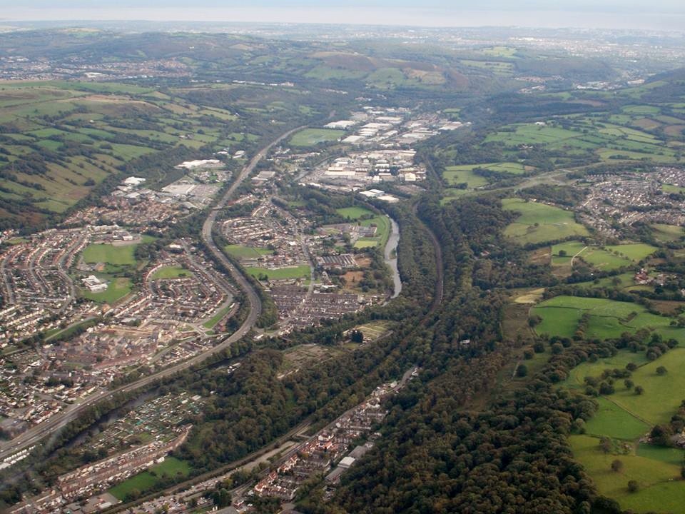 Aerial view of Treforest Trading Estate taken 9th October 2013 looking south , courtesy Mr Conway Shields. This photo covers almost exactly the same area as that taken in 1939. |
 Class31 |
Sunday 3rd of November 2013 02:37:38 PM |