Skip to main content
Britain from Above
Cymraeg
|
English
Login
|
Register
Toggle navigation
Home
Legacy
About
Map
Galleries
Groups
Help
Search
All Countries (96344)
England (82521)
Scotland (6398)
Wales (4321)
Rest of World (3104)
Belgium (7)
France (27)
Germany (2)
Guernsey (116)
Iran (8)
Iraq (6)
Ireland (1466)
Isle of Man (75)
Jersey (122)
Netherlands (20)
Northern Ireland (1163)
Spain (9)
Switzerland (26)
Damo's profile
Latest Activity
Saved Images
1
2
next
last
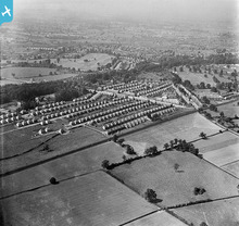
[EPW035776] Kenilworth Road, housing off the Kenpas Highway and environs, Stivichall Common,1931
[EPW035777] Housing off the Kenpas Highway and environs, Stivichall Common, from the south, 1931
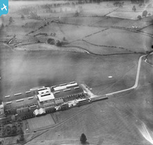
[EPW019271] Whitley Aerodrome, Whitley, 1927
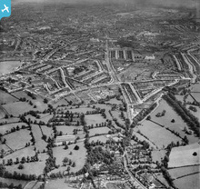
[EAW001165] Coundon and Chapel Fields, Coventry, from the west, 1946
[EAW001163] Allesley, Coundon and Chapel Fields, Coventry, from the west, 1946
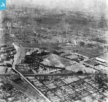
[EPW001196] Works in the Mile Lane and Quinton Road area, Coventry, 1920
[EPW061251] The residential area at Green Lane and Earlsdon, Coventry, from the south, 1939. This image has been affected by flare.
[EAW001162] Coundon and Chapel Fields, Coventry, from the north-west, 1946
1
2
next
last
This user has had no activity in the last year.