
Scheduled Maintenance
This website will undergo scheduled maintenance on Tuesday, September 10th, between 11:00 and 15:00, as well as on Thursday, September 12th, between 10:00 and 12:00. During this time, services may be temporarily disrupted. We apologise for any inconvenience.
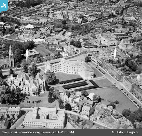
EAW005344 ENGLAND (1947). The Shire Hall, County Hall and the surrounding area, Taunton, 1947
© Copyright OpenStreetMap contributors and licensed by the OpenStreetMap Foundation. 2024. Cartography is licensed as CC BY-SA.
Nearby Images (26)
EAW005344

EAW005139

EAW005345

EAW005138

EAW015039

EAW049104

EAW005140

EAW015038

EPW027891

EAW051942

EAW005137

EAW005136

EAW005135

EAW015037

EAW051946

EAW051945

EAW005141

EAW049103

EPW041182

EPW013545

EAW051947

EAW051943

EAW005346

EPW027886

EPW041184

EPW041094

Details
| Title | [EAW005344] The Shire Hall, County Hall and the surrounding area, Taunton, 1947 |
| Reference | EAW005344 |
| Date | 13-May-1947 |
| Link | |
| Place name | TAUNTON |
| Parish | |
| District | |
| Country | ENGLAND |
| Easting / Northing | 322454, 124354 |
| Longitude / Latitude | -3.1055466945241, 51.012792051919 |
| National Grid Reference | ST225244 |
Pins
Be the first to add a comment to this image!